Stanwood, Washington facts for kids
Quick facts for kids
Stanwood
|
||
|---|---|---|
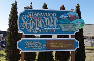
Welcome sign in eastern Stanwood
|
||
|
||
| Nickname(s):
Twin City
|
||
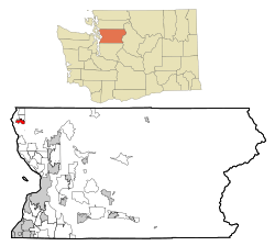
Location of Stanwood, Washington
|
||
| Country | United States | |
| State | Washington | |
| County | Snohomish | |
| Incorporated | October 19, 1903 | |
| Named for | Clara Stanwood Pearson | |
| Government | ||
| • Type | Mayor–council | |
| Area | ||
| • Total | 2.94 sq mi (7.62 km2) | |
| • Land | 2.93 sq mi (7.59 km2) | |
| • Water | 0.01 sq mi (0.03 km2) | |
| Elevation | 7 ft (2 m) | |
| Population
(2020)
|
||
| • Total | 7,705 | |
| • Estimate
(2022)
|
8,804 | |
| • Density | 2,629.69/sq mi (1,015.15/km2) | |
| Time zone | UTC-8 (Pacific (PST)) | |
| • Summer (DST) | UTC-7 (PDT) | |
| ZIP code |
98292
|
|
| Area code | 360 | |
| FIPS code | 53-67455 | |
| GNIS feature ID | 1512690 | |
Stanwood is a city in Snohomish County, Washington, United States. It's about 50 miles (80 km) north of Seattle. The city is located where the Stillaguamish River meets the sea, close to Camano Island. In 2020, about 7,705 people lived there.
For thousands of years, the Stillaguamish people lived in the Stanwood area. They had a village where Stanwood is today. The modern city started in 1866 as Centerville. It changed its name to Stanwood in 1877, named after Clara Stanwood Pearson, the wife of the new postmaster, Daniel O. Pearson. Stanwood became an official city in 1903.
A railroad was built in 1891, but it went around Stanwood, about 1 mile (1.6 km) to the east. This spot grew into its own town called East Stanwood, which became a city in 1922. For many years, Stanwood and East Stanwood were rivals. But in 1960, people voted to combine their governments, making them one city again.
Stanwood used to have many food processing factories. These factories were the biggest employers. Many people living in Stanwood were from Scandinavian countries. Since the 1990s, Stanwood has grown. It's now a place where people live and then travel to work in bigger cities like Seattle and Everett. The city has also added new areas with suburban neighborhoods. Stanwood is mainly served by State Route 532, which connects to Interstate 5. It also has a train station that opened in 2009.
Contents
History of Stanwood
Who lived in Stanwood first?
The Stillaguamish people, a Coast Salish tribe, have lived around the Stillaguamish River delta for thousands of years. In 1855, there was a Stillaguamish village at the river's mouth. It had three large potlatch houses and about 250 people. Other villages were nearby, with about 800 people in total. The area at the river's mouth is called lut sdᶻəlgʷas in Lushootseed, which means "strait" or "slough".
How did Stanwood begin?
The first American explorers came to the area in 1851. They were led by Snohomish guides. The first permanent American settlement was Centerville, a trading post started in 1866 by Robert Fulton. It was on the south side of the river. Centerville got a post office in 1870. Three years later, the settlement moved to the north side of the river.
In 1877, the post office was renamed Stanwood. This was done by Daniel O. Pearson, the new postmaster. He named it after his wife, Clara. Pearson also ran a general store and built a new steamboat wharf on the river.
Early Growth and Challenges
Loggers cleared the land around Stanwood. Farmers and ranchers then settled there. They used levees to manage the river. In 1876, the first Norwegian Lutheran church in the Pacific Northwest was built here. This brought many Scandinavian immigrants to the area.
Stanwood faced a big fire on June 2, 1892. It destroyed the church and thirteen other buildings. But volunteers saved some businesses and the town's liquor supply. By the end of the 1890s, the town had rebuilt. It had a weekly newspaper, a cannery, a horse racing track, a creamery, and a shingle mill. Stanwood officially became a city on October 19, 1903.
In the 1920s and 1930s, the Stillaguamish River's main flow changed. This made the old wharf too shallow for steamboats. So, businesses in Stanwood moved a block away from the riverfront.
The Twin Cities: Stanwood and East Stanwood
The Great Northern Railway built its tracks through the Stanwood area in 1891. But it went about 1 mile (1.6 km) east of the main town. This spot was less likely to flood. A depot was built there. Many businesses moved to this new area, including a bank.
This community around the depot was named "East Stanwood" in 1906. It became an official city on February 7, 1922. East Stanwood was later split by the Pacific Highway in the 1920s. Paved roads connected it to Stanwood and Camano Island.
The "Twin City" had separate governments, schools, banks, and factories. The schools for both cities joined in 1944. This ended a long football rivalry. By the 1950s, the two cities were working together more. In 1960, voters approved combining the two cities into one. This helped them build a new sewage treatment system.
Modern Stanwood Development
In the 1980s, a new shopping area began to grow east of the city. It was built around the new Stanwood High School. This area became a large shopping and entertainment center. It opened in 1995 with many businesses, restaurants, a movie theater, and an arcade.
This development led to many new suburban neighborhoods. The city's population doubled to almost 4,000 people by 2000. These new areas were added to the city in the early 2000s. In 2005, the city decided not to let Wal-Mart build a store in Stanwood. This was because many people wanted to support the local downtown businesses.
A new high school building was finished in 2021. It cost $147.5 million. A large new housing complex is also planned nearby. It will have apartments and townhomes.
Geography of Stanwood

Where is Stanwood located?
Stanwood covers about 2.84 square miles (7.36 km²). Most of this is land, with a small amount of water. The city is in the northwest part of Snohomish County. It's considered part of the Seattle metropolitan area. Stanwood is about 13 miles (21 km) west of Arlington and 20 miles (32 km) north of Everett. It's also 50 miles (80 km) north of Seattle.
Stanwood's borders are generally the Stillaguamish River to the south. To the west is 104th Drive Northwest. To the north are 276th Street Northwest and 290th Street Northwest. To the east is 68th Avenue Northwest. Most of the land in Stanwood is used for homes. Some areas are for businesses and factories.
Rivers and Waterways
The city is at the mouth of the Stillaguamish River. Here, the river flows into Port Susan, which is part of the Puget Sound. To the west is Davis Slough, which separates Stanwood from Camano Island.
The land in Stanwood ranges from 2 feet (0.6 m) above sea level near the river to 190 feet (58 m) in the hills. Five creeks and drainage basins flow through the city into the Stillaguamish River and Puget Sound. These include Church Creek, Douglas Creek, and Irvine Slough.
Flooding and Protection
Much of downtown Stanwood is in a 100-year flood zone. This means it's at risk of flooding from the Stillaguamish River. Many levees and dikes were built in the 1870s to protect the land. These were improved over the years.
Some older dikes were removed in the 2010s to help restore natural areas for wildlife. Some city buildings have also moved to higher ground to avoid floods. In 2020, the city started a project to control floods. It will cost $11 million and take 10 years to finish.
Economy of Stanwood
What kinds of jobs are in Stanwood?
In 2015, Stanwood had about 4,644 workers. The unemployment rate was 4.1 percent. Many people in Stanwood work in education and health care. Other common jobs are in manufacturing, retail, and food services.
Only about 14 percent of people who work in Stanwood actually live there. Most people travel to other cities for work. The most common places people commute to are Everett, Seattle, Mount Vernon, Arlington, and Marysville. The average trip to work for people in Stanwood was about 27.5 minutes. Most people drive alone to work.
Major Employers
The biggest employers in Stanwood are the Stanwood-Camano School District and the Josephine Sunset Home. They provide hundreds of jobs.
Another large employer used to be the Twin City Foods frozen food plant. It packaged frozen vegetables and fruits. This plant closed in 2017. The original plant was destroyed in a fire in 1996. A new plant opened later that year.
People of Stanwood
| Historical population | |||
|---|---|---|---|
| Census | Pop. | %± | |
| 1910 | 544 | — | |
| 1920 | 704 | 29.4% | |
| 1930 | 715 | 1.6% | |
| 1940 | 600 | −16.1% | |
| 1950 | 710 | 18.3% | |
| 1960 | 646 | −9.0% | |
| 1970 | 1,347 | 108.5% | |
| 1980 | 1,646 | 22.2% | |
| 1990 | 1,961 | 19.1% | |
| 2000 | 3,923 | 100.1% | |
| 2010 | 6,231 | 58.8% | |
| 2020 | 7,705 | 23.7% | |
| 2022 (est.) | 8,804 | 41.3% | |
| U.S. Decennial Census | |||
How many people live in Stanwood?
Stanwood is one of the smaller cities in Snohomish County. In the 2020 census, 7,705 people lived there. By 2035, the city and its nearby areas are expected to have about 11,085 people. The larger Stanwood area, which includes Camano Island, has about 33,000 people.
Who are the people of Stanwood?
Stanwood was once known for having a large Scandinavian population, especially Norwegians. They settled in the area in the early 1900s. In 1949, over 60 percent of Stanwood residents were of Norwegian, Swedish, or Danish background. By 2000, this number had changed, with about 17.6 percent of residents saying they had Scandinavian ancestry.
What is the population like?
In 2010, there were 6,231 people living in Stanwood. About 38% of households had children under 18. The average age in the city was 35.9 years. About 28.1% of residents were under 18. The city had slightly more females (52.7%) than males (47.3%).
Culture and Fun in Stanwood
Arts and Events
Stanwood has a lively arts community. The Stanwood–Camano Arts Guild puts on an annual spring art show. They also host the Art by the Bay festival in the summer. The guild helps display public art at local businesses. Stanwood is also a place for glass art because it's near the Pilchuck Glass School. This school was started in 1971 by glassblowing artists, including Dale Chihuly.
Stanwood hosts several yearly festivals and events. In February, there's a glass treasure hunt and a birding festival. These happen when snow geese and other birds migrate. In the summer, the city has weekend concerts downtown. There's also a farmers' market on Fridays from June to October.
Stanwood's two late summer festivals celebrate the area's farming history. The Community Fair, held since 1932, is called the "Best Lil' Fair in the West." It attracts 12,000 visitors each year. It features 4-H presentations, animal shows, a parade, and carnival rides. The Harvest Jubilee, started in 2007, includes art shows, produce contests, and tours of local farms.
Parks and Recreation
Stanwood has eight public parks. They cover about 86 acres (35 ha) of open space. These parks include nature areas, playgrounds, sports fields, and boat launches. The largest park is Heritage Park downtown, which is 44 acres (18 ha). It has sports fields, walking trails, picnic areas, a dog park, and a skate park. Nearby regional parks include Kayak Point County Park and Wenberg County Park.
The city is developing new parks along the Stillaguamish River. One site, the former Hamilton lumber mill, will have a boat launch and public dock. It includes an old smokestack that is decorated for holidays. Another site, the 15-acre (6.1 ha) Ovenell dairy farm, will also have a boat launch, natural habitats, and a demonstration farm.
Media and Library
Stanwood has one weekly newspaper, the Stanwood Camano News. It started in 1903 as the Stanwood Tidings.
The city's public library is part of the Sno-Isle Libraries system. It's in a 5,400 square foot (500 m²) building. The first library was built in 1922. The current building was built in 1970 and expanded in 1986.
Historic Buildings to Explore
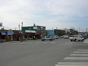
The downtown areas of Stanwood and East Stanwood have many historic buildings. They date back to the early 1900s.
Stanwood has two buildings listed on the National Register of Historic Places. These are important historic sites. The D. O. Pearson House was built in 1890. It was the home of the Pearson family who helped found the town. It is now a pioneer museum. The other building is the Stanwood IOOF Public Hall, built in 1903. It was used by different groups. It is now the Floyd Norgaard Cultural Center, a museum and community center.
Famous People from Stanwood
- Nels Bruseth, a forest ranger and painter
- Fanny Cory, a cartoonist and illustrator
- Sarah Jones, an Olympic rower
- T. J. Oshie, a professional hockey player
- Eugene H. Peterson, a clergyman and author
- Ted Richards, an American football player
- Francesca Woodman, a photographer
Education in Stanwood
Schools in Stanwood
Public schools in Stanwood are run by the Stanwood-Camano School District. This district covers Stanwood and nearby areas like Camano Island. In 2014, about 4,554 students were in the district. It has eleven schools, including one high school, two middle schools, and four elementary schools in Stanwood. The old high school, built in 1971, was replaced in 2021 by a new building. This new building helps handle the growing number of students.
Colleges Near Stanwood
The closest colleges are Skagit Valley College in Mount Vernon and Everett Community College in Everett. In 2006, Stanwood offered land for a possible four-year university campus. However, the university project was later canceled.
Transportation in Stanwood
Roads and Highways
Stanwood is on State Route 532. This highway goes east–west and connects Camano Island to Interstate 5 east of Stanwood. The city also has two other main roads: Pioneer Highway and Marine Drive. Pioneer Highway used to be part of the Pacific Highway. Marine Drive goes south towards Marysville.
Buses and Trains
Public transportation in Stanwood is provided by Community Transit and Island Transit. Community Transit runs local bus service from Stanwood to nearby towns. On weekdays, it also has express buses to Lynnwood City Center station. Island Transit provides service to Camano Island and commuter service to Mount Vernon and Everett. A new service called Snow Goose Transit started in 2022. It offers minibus service in Stanwood and parts of Camano Island.
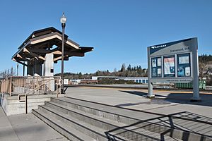
Stanwood has a north–south railroad owned by BNSF Railway. This railroad carries both cargo and passenger rail trains. Amtrak's Cascades train offers daily passenger service at Stanwood station in downtown Stanwood. You can take this train south to Seattle or north to Vancouver, British Columbia. The train station opened on November 21, 2009. This brought back passenger train service that had stopped in 1971.
City Services
Electric power in Stanwood comes from the Snohomish County Public Utility District (PUD). Cascade Natural Gas provides natural gas service. Stanwood has two main broadband internet providers: Frontier and Wave Broadband.
The city government provides water and water treatment services. The city gets its water from underground aquifers. Wastewater and stormwater are collected and treated at two treatment plants. Trash and recycling collection is handled by Waste Management.
See also
 In Spanish: Stanwood (Washington) para niños
 | William L. Dawson |
 | W. E. B. Du Bois |
 | Harry Belafonte |


