Mount Vernon, Washington facts for kids
Quick facts for kids
Mount Vernon
|
||
|---|---|---|
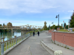
Downtown Waterfront
|
||
|
||
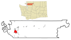
Location of Mount Vernon in Washington State
|
||
| Country | United States | |
| State | Washington | |
| County | Skagit | |
| Incorporated | July 5, 1889 | |
| Named for | Mount Vernon | |
| Government | ||
| • Type | Mayor–council | |
| Area | ||
| • City | 12.62 sq mi (32.70 km2) | |
| • Land | 12.30 sq mi (31.85 km2) | |
| • Water | 0.33 sq mi (0.84 km2) 2.46% | |
| Elevation | 180 ft (54.9 m) | |
| Population
(2020)
|
||
| • City | 35,219 | |
| • Estimate
(2021)
|
35,404 | |
| • Density | 2,863.33/sq mi (1,105.78/km2) | |
| • Urban | 62,966 (US: 435th) | |
| • Metro | 130,696 (US: 313th) | |
| Time zone | UTC-8 (PST) | |
| • Summer (DST) | UTC-7 (PDT) | |
| ZIP codes |
98273, 98274
|
|
| Area code | 360, 564 | |
| GNIS feature ID | 1512485 | |
Mount Vernon is an exciting city in Washington. It is the main city in Skagit County. You can find it in the beautiful Skagit River Valley.
The city is about 51 miles (82 km) south of the border with Canada. It is also about 60 miles (97 km) north of Seattle. In 2020, about 35,219 people lived there. This makes it one of the largest cities in Washington.
Mount Vernon is famous for its yearly Skagit Valley Tulip Festival. During this festival, millions of bright tulips bloom in the valley. The city also hosts a fun street fair downtown. Mount Vernon has grown a lot. It is a key place in Northwest Washington. You can easily reach it by Interstate 5 and Amtrak trains.
Contents
History of Mount Vernon
Early Beginnings
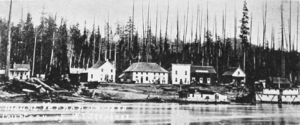
The first settlers arrived in 1870. Jasper Gates and Joseph Dwelley built homes by the Skagit River. Later, in 1877, Harrison Clothier came to teach. He also started a business with E.G. English. These two men are known as the city's founders.
A post office opened in November 1877. Clothier became the first postmaster. The city was named after Mount Vernon, which was George Washington's home. The founders planned the city while the area was still covered in trees.
Logging was Mount Vernon's first big industry. Loggers set up camps to cut down trees. The community grew fast with hotels and saloons. They were built near English & Clothiers' store by the river. Large ships could not reach the city easily. A huge log jam blocked the river.
This made mail carriers use canoes to reach Skagit City. Mining nearby in 1880 brought some growth. But the mines were not very deep. More logging started, but it was not very profitable. By 1881, only about 75 people lived in Mount Vernon.
The city grew steadily in the 1880s. The Odd Fellows Lodge opened in 1882. The first newspaper, The Skagit News, started in 1884. The first church, a Baptist church, also began in 1884.
Mount Vernon's future became secure in November 1884. It was chosen as the new county seat for Skagit County. This role moved from La Conner. The Odd Fellows building was used for county needs. A permanent courthouse was built later.
Railroad and Growth into the 20th Century
Mount Vernon's central spot helped it grow. It was close to mining, logging, and farming areas. It also had access to Puget Sound. The city needed a railroad connection to other places. These included Everett, Seattle, and Vancouver, B.C..
In 1889, a group worked to bring a railroad line. Their efforts succeeded. The Great Northern Railway agreed to build through the city. This line was finished in 1891. The city also tried to get the Seattle, Lake Shore and Eastern Railway. But that plan did not work out.
The railroad's arrival brought many new businesses and people. Mount Vernon officially became a city on July 5, 1893. That same year, a large brick courthouse was built. It still stands today on Main Street.
Mount Vernon's economy was stable. It did not have a sudden "boom" like some other towns. The city had its first big fire in 1891. Several blocks along the waterfront were destroyed. The riverfront also eroded that year. But new buildings quickly replaced the damaged ones.
In 1891, several important buildings were constructed. These included a large brick schoolhouse. The Mount Vernon Opera House was also built. Growth slowed after a financial crisis in 1893. After a flood in 1894, the first dike was built. This helped protect the city from the Skagit River.
Another big fire in 1900 destroyed many old buildings. More businesses burned in 1903. The city finally got a water system in 1902.
Later Events and Transportation
The city grew again in the 1910s. It became the southern end of an interurban railroad line. This line carried people and goods. It connected Mount Vernon to Bellingham and other towns. The line opened on August 31, 1912.
Mount Vernon businesses wanted the line to go further south. They wanted it to connect to Everett. But the company faced problems. These included a weak economy and World War I. The line also had many breakdowns. So, the extension was delayed.
The Pacific Highway opened in 1920. This new road between Seattle and Bellingham was a threat to the interurban line. After more accidents, passenger service stopped in June 1930.
In 1969, Interstate 5 was built through downtown. This highway separated downtown from many homes. It also opened up farmlands north of the city for building. Many downtown businesses moved to these new areas.
Culture and Community
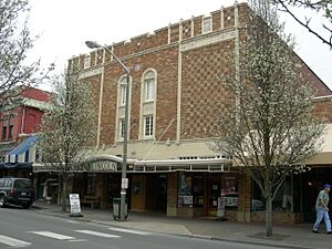
The Historic Lincoln Theatre is on First Street. It was built in 1926. It used to show vaudeville acts and silent movies. Today, it hosts live shows and concerts. It also shows classic and new movies all year.
The Lincoln Theatre is special. It is one of only 98 theaters in the U.S. with its original Wurlitzer theatre organ. This organ is often played before shows. The Skagit Symphony also performs in the area.
The city's public library moved to a new building in 2024. This new place is called the Mount Vernon Library Commons. It cost $56 million to build. It has meeting rooms and a community center. There is also a large parking garage with 275 spots.
The parking garage is very modern. It has the biggest city-owned electric vehicle charging station in the U.S. It has 76 charging spots. There are also charging lockers for electric bicycles.
Geography and Climate
Mount Vernon covers about 12.61 square miles (32.66 km2) of land. Most of this is land, about 12.30 square miles (31.86 km2). A small part, about 0.31 square miles (0.80 km2), is water.
Climate in Mount Vernon
Mount Vernon has a mild climate. It has cool, wet winters. Summers are warm and usually drier. This type of weather is common in the Pacific Northwest.
| Climate data for Mount Vernon (1971–2000) | |||||||||||||
|---|---|---|---|---|---|---|---|---|---|---|---|---|---|
| Month | Jan | Feb | Mar | Apr | May | Jun | Jul | Aug | Sep | Oct | Nov | Dec | Year |
| Mean daily maximum °F (°C) | 45.7 (7.6) |
49.5 (9.7) |
53.4 (11.9) |
58.1 (14.5) |
64.0 (17.8) |
68.4 (20.2) |
73.0 (22.8) |
74.1 (23.4) |
69.1 (20.6) |
60.0 (15.6) |
50.9 (10.5) |
46.0 (7.8) |
59.4 (15.2) |
| Daily mean °F (°C) | 39.9 (4.4) |
42.7 (5.9) |
45.7 (7.6) |
49.3 (9.6) |
54.7 (12.6) |
58.9 (14.9) |
62.3 (16.8) |
62.9 (17.2) |
58.3 (14.6) |
50.9 (10.5) |
44.5 (6.9) |
40.3 (4.6) |
50.9 (10.5) |
| Mean daily minimum °F (°C) | 34.1 (1.2) |
35.9 (2.2) |
37.9 (3.3) |
40.5 (4.7) |
45.4 (7.4) |
49.4 (9.7) |
51.5 (10.8) |
51.6 (10.9) |
47.5 (8.6) |
41.8 (5.4) |
38.1 (3.4) |
34.6 (1.4) |
42.4 (5.8) |
| Average precipitation inches (mm) | 4.22 (107) |
2.85 (72) |
2.81 (71) |
2.53 (64) |
2.42 (61) |
1.95 (50) |
1.20 (30) |
1.34 (34) |
1.70 (43) |
2.89 (73) |
4.83 (123) |
3.96 (101) |
32.7 (829) |
| Source: NOAA (normals, 1971–2000) | |||||||||||||
Protecting from Floods
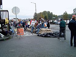
The downtown area of Mount Vernon is next to the Skagit River. This area has often had floods. This happens especially when there is heavy rain in the Cascades. In the past, people had to build sandbag walls. These walls were 5 feet (1.5 m) high and stretched for six city blocks. It took many hours and hundreds of volunteers.
In 2007, the city bought a special mobile flood wall. It came from a company in Norway. This was the first one sold in the United States. The new flood wall is 4 feet (1.2 m) high. A few volunteers can set it up in just three hours. This is much faster than using sandbags.
A permanent flood wall was finished in 2019. This helps protect the city even more. After the flood control was in place, plans were made. A committee wants to improve the riverfront area. It is currently used for parking and a farmer's market. They plan to build a walkway with new buildings. These buildings might have homes and shops. A new parking garage is also planned. The city experienced flooding again in 2017 and 2021.
Getting Around: Transportation
Mount Vernon's main travel spot is Skagit Station. It was built in 2004. You can catch Amtrak trains and buses there. Travelers can easily switch between different types of transport.
Skagit Transit buses stop at the station. So do Greyhound buses and local taxis. The Amtrak Cascades train also stops there. Skagit Transit has a bus that goes to Everett Station. From there, you can take the Sounder commuter train to Seattle.
Skagit Regional Airport is about 5 mi (8.0 km) northwest. It is used for smaller planes. Two cargo airlines also use it. The closest airport for regular passenger flights is Bellingham International Airport. It is about 25 miles (40 km) north.
Main Roads
- Interstate 5 runs north and south. It goes from the Mexican border all the way to Canada. It connects Mount Vernon to big cities like Seattle and Portland.
- State Route 9 runs next to Interstate 5. It links Mount Vernon to towns like Snohomish to the south. It also goes to Sedro-Woolley and the Canadian border to the north.
- State Route 536 goes from SR 20 into downtown Mount Vernon and Interstate 5.
- State Route 538 runs east and west. It connects Interstate 5 to SR 9 in Mount Vernon.
Population and People
| Historical population | |||
|---|---|---|---|
| Census | Pop. | %± | |
| 1890 | 770 | — | |
| 1900 | 1,120 | 45.5% | |
| 1910 | 2,381 | 112.6% | |
| 1920 | 3,341 | 40.3% | |
| 1930 | 3,690 | 10.4% | |
| 1940 | 4,278 | 15.9% | |
| 1950 | 5,230 | 22.3% | |
| 1960 | 7,921 | 51.5% | |
| 1970 | 8,804 | 11.1% | |
| 1980 | 13,009 | 47.8% | |
| 1990 | 17,647 | 35.7% | |
| 2000 | 26,232 | 48.6% | |
| 2010 | 31,743 | 21.0% | |
| 2020 | 35,219 | 11.0% | |
| 2021 (est.) | 35,404 | 11.5% | |
| U.S. Decennial Census 2020 Census |
|||
Mount Vernon has grown a lot over the years. In 1890, only 770 people lived there. By 2020, the population was 35,219. The city's population grew by over 34% between 2000 and 2020. This shows it is a growing community.
In 2010, there were 31,743 people living in Mount Vernon. About 28% of the people were under 18 years old. About 12% were 65 years or older. The city has a good mix of different age groups.
Famous People from Mount Vernon
Many interesting people have connections to Mount Vernon. Here are a few:
- Glenn Beck, a well-known television and radio host.
- Jim Caviezel, an actor famous for his roles in movies and TV shows.
- Scott Clements, a professional poker player.
- David Gates, a singer and songwriter from the band Bread.
- Craig Kelly, a pioneer in the sport of snowboarding.
- Kyle Kendrick, a former Major League Baseball pitcher.
- Graham Kerr, a culinary expert known as "The Galloping Gourmet."
- Ross Mathews, a TV personality often seen on "The Tonight Show."
- T. J. Oshie, an ice hockey player for the Washington Capitals and a U.S. Olympian.
Sister Cities
Mount Vernon has a special connection with another city. This is called a "Sister City" relationship. It helps people from different places learn about each other.
 Chilliwack, British Columbia, Canada
See also
 In Spanish: Mount Vernon (Washington) para niños
 | Claudette Colvin |
 | Myrlie Evers-Williams |
 | Alberta Odell Jones |


