Woodway, Washington facts for kids
Quick facts for kids
Woodway, Washington
|
|
|---|---|

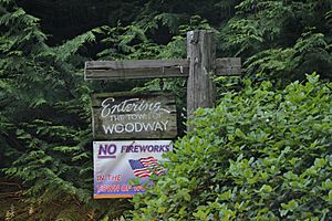
Boundary sign
|
|

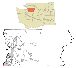
Location of Woodway, Washington
|
|
| Country | United States |
| State | Washington |
| County | Snohomish |
| Incorporated | 1958 |
| Government | |
| • Type | Mayor–council |
| Area | |
| • Total | 1.43 sq mi (3.71 km2) |
| • Land | 1.17 sq mi (3.03 km2) |
| • Water | 0.26 sq mi (0.68 km2) |
| Elevation | 203 ft (62 m) |
| Population
(2020)
|
|
| • Total | 1,318 |
| • Estimate
(2022)
|
1,305 |
| • Density | 1,128.4/sq mi (435.7/km2) |
| Time zone | UTC-8 (Pacific (PST)) |
| • Summer (DST) | UTC-7 (PDT) |
| ZIP code |
98020
|
| Area code, | 206, 425 |
| FIPS code | 53-79835 |
| GNIS feature ID | 1512815 |
Woodway is a small city in Snohomish County, Washington, United States. In 2020, about 1,318 people lived there.
Woodway is known for being a wealthy area. It ranks as one of the richest places in Washington state based on how much money people earn there. It is the richest area in Snohomish County.
Contents
History of Woodway
How Woodway Started
Woodway was founded in 1914 by David Whitcomb. He was a lawyer who became a real estate developer. He bought about 320 acres of land. Then, he started building a community called "Woodway Park."
The city now includes areas north and south of the original park. These areas have different sized lots for homes. The original park still has its quiet, wooded feel.
Becoming an Official City
Woodway officially became a city on February 26, 1958. This was done to protect its many trees and avoid being taken over by the nearby city of Edmonds.
To keep the area natural, rules were set for lot sizes. Most new homes needed at least 2 acres of land. However, smaller existing lots were allowed to stay as they were. The city was named "Woodway" because of its beautiful natural setting.
Schools and Changes Over Time
In the past, high school students from Woodway went to Edmonds High School. A new Woodway High School opened in 1970. Later, in 1990, it joined with Edmonds High School. This created the Edmonds Woodway High School we know today.
In 1986, state laws changed, and Woodway was reclassified as a "city." Even so, it often still calls itself the "Town of Woodway." The city uses the Edmonds post office and shares its 98020 ZIP Code.
For a long time, Woodway did not have many businesses or sidewalks. It was mostly for single-family homes, which were very expensive. In 1999, a new housing development called Woodway Highlands was approved. The first homes there were finished in 2003. As of 2021, no part of Woodway is set aside for businesses.
Woodway is unique because some of its phone numbers use the 206 area code. This is the only city in Snohomish County with this area code. However, some areas switched to the area code 425 in 1997.
Geography of Woodway
Location and Surroundings
Woodway is located at the southwest edge of Snohomish County. To the north and east, it borders Edmonds. To the south, it borders Shoreline in King County.
To the west of Woodway is Puget Sound. The town sits on a hill that looks out over Puget Sound. The BNSF Railway has train tracks along the shoreline.
Size of the City
According to the United States Census Bureau, Woodway covers a total area of about 1.43 square miles (3.71 square kilometers). Of this, about 1.17 square miles (3.03 square kilometers) is land. The remaining 0.26 square miles (0.68 square kilometers) is water.
Population and People
| Historical population | |||
|---|---|---|---|
| Census | Pop. | %± | |
| 1960 | 713 | — | |
| 1970 | 879 | 23.3% | |
| 1980 | 832 | −5.3% | |
| 1990 | 914 | 9.9% | |
| 2000 | 936 | 2.4% | |
| 2010 | 1,307 | 39.6% | |
| 2020 | 1,318 | 0.8% | |
| 2022 (est.) | 1,305 | −0.2% | |
| U.S. Decennial Census | |||
Population in 2010
In 2010, there were 1,307 people living in Woodway. There were 448 households, which are groups of people living together. Most of these (373) were families.
The city had about 1,177.5 people per square mile. There were 466 housing units, like houses or apartments.
Diversity in Woodway
Most people in Woodway were White (87.5%). Other groups included Asian (7.8%), African American (0.6%), and Native American (0.8%). About 2.7% of the population was Hispanic or Latino.
Households and Age
About 41.5% of households had children under 18 living with them. Most households (75.7%) were married couples.
The average age in Woodway was 45.8 years old. About 28.3% of residents were under 18. About 14.4% were 65 years or older. The population was almost evenly split between males (49.2%) and females (50.8%).
Getting Around Woodway
Roads and Public Transport
State Route 104 passes by the northeast corner of Woodway. This road connects the city to the Edmonds ferry terminal and Interstate 5.
The BNSF Railway tracks run along Woodway's western coast. These tracks are used by the Sounder commuter rail service, which stops at the Edmonds station.
Woodway is part of the area served by Community Transit, a public transportation system. However, its regular buses do not stop in Woodway. The city does offer a special "dial-a-ride" service for people who need it.
Famous People from Woodway
- Morris Graves, a well-known artist
- Matt Cameron, a musician
- Jeannette Wood, a state legislator
See also
 In Spanish: Woodway (Washington) para niños
 | Emma Amos |
 | Edward Mitchell Bannister |
 | Larry D. Alexander |
 | Ernie Barnes |

