
Island County, Washington facts for kids
Quick facts for kids
Island County
|
|
|---|---|

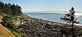
Shoreline at Fort Ebey State Park within U.S. Ebey's Landing National Historical Reserve on Whidbey Island
|
|

Location within the U.S. state of Washington
|
|
 Washington's location within the U.S. |
|
| Country | |
| State | |
| Founded | 1852 |
| Seat | Coupeville |
| Largest city | Oak Harbor |
| Area | |
| • Total | 517 sq mi (1,340 km2) |
| • Land | 208 sq mi (540 km2) |
| • Water | 309 sq mi (800 km2) 60%% |
| Population
(2020)
|
|
| • Total | 86,857 |
| • Estimate
(2023)
|
86,267 |
| • Density | 381/sq mi (147/km2) |
| Time zone | UTC−8 (Pacific) |
| • Summer (DST) | UTC−7 (PDT) |
| Congressional district | 2nd |
Island County is a special place in the state of Washington, USA. In 2020, about 86,857 people lived there. Its main town, called the county seat, is Coupeville. The biggest city is Oak Harbor.
The name "Island County" makes sense because it's made up entirely of islands! It has two big islands, Whidbey and Camano. There are also seven smaller islands like Baby, Ben Ure, and Smith. Island County was formed on December 22, 1852. It was created from Thurston County by the government of Oregon Territory. This makes it one of the oldest counties in Washington. Long ago, it was much larger, including areas that are now Snohomish, Skagit, Whatcom, and San Juan Counties.
Island County is part of the Oak Harbor, Washington Micropolitan Statistical Area. This area is also included in the larger Seattle–Tacoma, WA Combined Statistical Area.
Contents
Where is Island County?
Island County is located in the Puget Sound area of Washington. It's known for its beautiful water views. The county covers a total area of about 517 square miles. Most of this area, about 309 square miles (60%), is water! The land area is about 208 square miles.
Island County is the second smallest county in Washington by land area. Only San Juan County is smaller. It's also the second smallest by total area, after Wahkiakum County.
Important Waterways and Islands
Special Protected Areas
- Pacific Northwest National Scenic Trail (a long hiking trail)
- Ebey's Landing National Historical Reserve (a place that protects history and nature)
Who Lives in Island County?
The number of people living in Island County has grown a lot over the years. Here's a quick look at how the population has changed:
| Historical population | |||
|---|---|---|---|
| Census | Pop. | %± | |
| 1860 | 294 | — | |
| 1870 | 626 | 112.9% | |
| 1880 | 1,087 | 73.6% | |
| 1890 | 1,787 | 64.4% | |
| 1900 | 1,870 | 4.6% | |
| 1910 | 4,704 | 151.6% | |
| 1920 | 5,489 | 16.7% | |
| 1930 | 5,369 | −2.2% | |
| 1940 | 6,098 | 13.6% | |
| 1950 | 11,079 | 81.7% | |
| 1960 | 19,638 | 77.3% | |
| 1970 | 27,011 | 37.5% | |
| 1980 | 44,048 | 63.1% | |
| 1990 | 60,195 | 36.7% | |
| 2000 | 71,558 | 18.9% | |
| 2010 | 78,506 | 9.7% | |
| 2020 | 86,857 | 10.6% | |
| 2023 (est.) | 86,267 | 9.9% | |
| U.S. Decennial Census | |||
Population in 2020
In 2020, there were 86,857 people living in Island County. There were about 35,917 households, which are groups of people living together. The population density was about 416 people per square mile of land.
Most residents (78.2%) were White. Other groups included African American (2.8%), Asian (4.6%), and Native American (0.8%). About 8.2% of the population identified as Hispanic or Latino.
About 17% of the people were under 18 years old. About 27.8% were 65 years or older.
What People Do
In 2010, the average income for a household in the county was about $57,190 per year. For families, the average income was about $68,106. About 8% of the population lived below the poverty line. This included 12.1% of those under 18 years old.
Getting Around Island County
The main islands of Island County, Whidbey Island and Camano Island, have several important roads. These are called Washington State Routes.
- SR 20 and SR 525 are on Whidbey Island.
- SR 532 is on Camano Island.
SR 20 connects to Port Townsend by a ferry. It leaves the county to the north over the famous Deception Pass Bridge. SR 525 connects to Mukilteo by another ferry. SR 532 connects Camano Island to the east over the Camano Gateway Bridge.
The islands also have a bus service called Island Transit. It's special because it's usually free or pre-paid, making it easy for people to travel.
Towns and Cities
Island County has several communities, from small towns to larger cities.
Cities
- Langley
- Oak Harbor (the largest city)
Town
- Coupeville (This is the county seat, where the main government offices are.)
Other Communities
There are also several smaller communities. Some of these are called Census-designated places (CDPs), which are special areas defined for census purposes. Others are unincorporated communities, meaning they don't have their own local government.
- Camano (CDP)
- Clinton (CDP)
- Freeland (CDP)
- Whidbey Island Station (CDP, a military base)
- Austin
- Bayview
- Greenbank
- Keystone
- Maxwelton
- Sandy Hook
- Utsalady
Juniper Beach is one of these communities. It's known for its water district, which is named after it.
Images for kids
-
Shoreline at Fort Ebey State Park within U.S. Ebey's Landing National Historical Reserve on Whidbey Island
See also
 In Spanish: Condado de Island para niños
