Freeland, Washington facts for kids
Quick facts for kids
Freeland, Washington
|
|
|---|---|

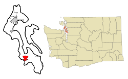
Location of Freeland, Washington
|
|
| Country | United States |
| State | Washington |
| County | Island |
| Area | |
| • Total | 3.9 sq mi (10.1 km2) |
| • Land | 3.9 sq mi (10.1 km2) |
| • Water | 0 sq mi (0.0 km2) |
| Elevation | 115 ft (35 m) |
| Population
(2020)
|
|
| • Total | 2,252 |
| • Density | 577.5/sq mi (223.0/km2) |
| Time zone | UTC-8 (Pacific (PST)) |
| • Summer (DST) | UTC-7 (PDT) |
| ZIP code |
98249
|
| Area code(s) | 360 |
| Telephone exchanges | 321, 331, 730 |
| FIPS code | 53-25510 |
| GNIS feature ID | 1505034 |
Freeland is a small community located on Whidbey Island in Island County, Washington, United States. It's known as a census-designated place (CDP), which means it's a specific area identified by the census bureau. In 2020, about 2,252 people lived there.
The town got its unique name because of how it started. In the early 1900s, it was founded as a socialist commune. This meant the people who started it believed the land should be "free" for everyone to use and share. Some of the first settlers had even tried a similar idea in a place called Equality Colony nearby.
Contents
Discovering Freeland's Past: A Look at Its History
How Freeland Began: The Free Land Association
In 1900, some people from the Equality Colony, led by George Washington Daniels, decided to start a new community. They created the Free Land Association. They bought land and aimed to make it "free" for members.
Members could buy shares in the association's store and machinery funds. The store followed Rochdale Principles, which are rules for fair and cooperative businesses. The idea was that members could use the money they earned from these shares to pay for their land. This made the land seem "free" to them.
Changes to the Land Plan
However, by 1902, the original plan didn't quite work out as expected. The colony announced that new settlers would have to buy their land directly. The dream of land being completely "free" through share dividends wasn't possible anymore.
Designing the Town: Early Layout
George Washington Daniels designed the first part of Freeland. He created five-acre plots of land with wide streets. More areas were added to the town over the next few years.
A Different Kind of Community: Cooperation and Sharing
Freeland was different from other colonies on the island. It was a "cooperative profit-sharing association." This means people worked together and shared the money they earned. It wasn't as strict as some other communities where everything was shared equally. They described themselves as socialists who also used some business ideas.
Life in Early Freeland: Schools and Travel
In its early days, Freeland didn't have its own school. Children had to travel three miles to Useless Bay for their education. It was hard to get around because there weren't many roads. To help with travel and trade, John H. Prather, Daniels' son-in-law, bought several boats. These boats carried goods and people between Freeland and Everett, which was the closest big town on the mainland.
Exploring Freeland's Location: Geography
Freeland is located on the southern part of Whidbey Island. It sits on a narrow strip of land, called an isthmus. This strip is between the south end of Holmes Harbor and Mutiny Bay. Holmes Harbor is a long inlet, and Mutiny Bay is on Admiralty Inlet.
Getting Around: Roads and Distances
Washington State Route 525 goes right through Freeland. This road connects Freeland to other towns. You can drive about 9 miles east to Clinton. Or, you can go about 12 miles northwest to SR 20 at Keystone. Oak Harbor is further north, about 28 miles from Freeland, if you take SR 525 and SR 20.
The total area of Freeland is about 10.1 square kilometers (about 3.9 square miles). All of this area is land.
People of Freeland: Demographics
In 2020, the population of Freeland was 2,252 people. The community is made up of different kinds of families and individuals. The median age of people living in Freeland is 43 years old.
Fun in Freeland: Outdoor Recreation
Freeland and its surroundings offer many cool places to explore and have fun outdoors.
Double Bluff Beach and State Park
About 2 miles south of Freeland, you'll find Double Bluff Beach and State Park. This is a popular spot on Whidbey Island. You can look for shellfish or just enjoy the quiet along the shores of Useless Bay and Admiralty Inlet. It's a great place to relax by the water.
South Whidbey State Park
If you head about 6 miles northwest of Freeland, you'll reach South Whidbey State Park. This park has access to the beach and trails that wind through forests. You can see both newer trees and very old, tall trees here.
Freeland Park on Holmes Harbor
Right in town, on the north side, is Freeland Park. It's located on Holmes Harbor. This park has a beach, a boat ramp, and places to tie up boats. There are also picnic tables and a playground for kids. Every year, they have a fireworks celebration here on the Third of July!
Holmes Harbor Golf Club
For those who enjoy golf, the Holmes Harbor Golf Club is nearby. It's an 18-hole public golf course. You can play golf while enjoying nice views of Holmes Harbor.
See also
 In Spanish: Freeland (Washington) para niños
 | May Edward Chinn |
 | Rebecca Cole |
 | Alexa Canady |
 | Dorothy Lavinia Brown |

