
Mill Creek, Washington facts for kids
Quick facts for kids
Mill Creek
|
||
|---|---|---|

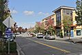
Main Street in the Mill Creek Town Center
|
||
|
||

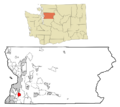
Location of Mill Creek, Washington
|
||
| Country | United States | |
| State | Washington | |
| County | Snohomish | |
| Incorporated | September 30, 1983 | |
| Government | ||
| • Type | Council–manager | |
| Area | ||
| • Total | 4.66 sq mi (12.06 km2) | |
| • Land | 4.64 sq mi (12.03 km2) | |
| • Water | 0.01 sq mi (0.04 km2) | |
| Elevation | 377 ft (115 m) | |
| Population
(2020)
|
||
| • Total | 20,926 | |
| • Estimate
(2022)
|
20,828 | |
| • Density | 4,499.78/sq mi (1,737.55/km2) | |
| Time zone | UTC-8 (Pacific (PST)) | |
| • Summer (DST) | UTC-7 (PDT) | |
| ZIP codes |
98012, 98082
|
|
| Area code | 425 | |
| FIPS code | 53-45865 | |
| GNIS feature ID | 1534566 | |

Mill Creek is a city in Snohomish County, Washington, United States. It is located between the cities of Everett and Lynnwood. Mill Creek is about 20 miles (32 km) northeast of Seattle. In 2020, the city had a population of 20,926 people.
Mill Creek is known as one of the wealthier suburbs in the Seattle metropolitan area. It was first planned in the 1970s as a special community. This plan included a country club and a golf course. The city officially became a city in 1983. Since then, it has grown a lot. The city's main shopping and activity area is the Mill Creek Town Center. This center opened in 2004.
Contents
History of Mill Creek
How Mill Creek Started
The area where Mill Creek is now was first settled by farming families in the early 1900s. In 1931, a doctor named Manch N. Garhart bought 800 acres (320 ha) of land. He grew apples and pears there and also raised cattle. This land was called Lake Dell Farm. Later, in 1967, the farm was sold to real estate developers. This happened because farming was not as profitable anymore.
In the 1960s and 1970s, developers saw this land as a great spot for a new, planned community. It was close to the recently built Interstate 5. The first idea for this community was called "Olympus." It would have homes, a shopping center, and a golf course.
In 1973, a Japanese company called Tokyu Land Development bought the project. They renamed it "Mill Creek." Even though there was no mill or creek with that name nearby at the time, the name stuck. (Later, a small stream was renamed Mill Creek in 2001).
Building the Community
The plan for Mill Creek was approved in 1974. A group called the homeowners association was set up to help manage the area. The plan included 4,600 homes and an 18-hole golf course. Construction began in 1975 with the golf course and country club. The first homes were built the next year. These homes were designed to look like country houses. The last part of the original Mill Creek development was finished in 2003.
Becoming a City and Growing
By 1983, most of the first homes were built. More than 3,000 people lived there, which was enough for the area to become a city. Residents wanted to become a city to manage their own services and taxes. Mill Creek officially became a city on September 30, 1983. It was the first new city in Snohomish County in many years.
After becoming a city, Mill Creek set up its own police department, library, and other services. The city also started to grow by adding nearby areas. This process is called annexation. In 1987, Mill Creek added its first new area. Over the years, the city continued to annex more land and neighborhoods. This included areas like Murphy's Corner and the Thomas Lake area. These annexations helped the city's population grow a lot.
Mill Creek in the 21st Century
In the late 1980s, Mill Creek planned to create a new downtown area. This area would have shops, offices, parks, and trails. The Mill Creek Town Center began construction in 2001 and opened in phases by 2007. It became a lively center for the city.
The main road through Mill Creek, State Route 527, was widened in the 1990s and 2000s. It now has more lanes, sidewalks, and bike lanes. This road also has stops for the Swift Green Line bus rapid transit system, which started in 2019.
The city also planned a second main area called the East Gateway. This area would have apartments, townhouses, offices, and shops. It includes new developments like "The Farm at Mill Creek."
Geography
Mill Creek covers an area of about 4.69 square miles (12.15 square kilometers). The city's borders are generally defined by North Creek to the west. To the north, it borders 132nd Street Southeast and the city of Everett. To the east, it's bordered by Seattle Hill Road and 35th Avenue Southeast. To the south, it's bordered by 163rd Street Southeast and North Creek County Park.
Several creeks flow through Mill Creek, including North Creek, Penny Creek, and Nickel Creek. In 2001, a small stream called Smokehouse Creek was renamed Mill Creek. This gave the city a natural feature with its name. The original part of Mill Creek is east of State Route 527. It has 21 neighborhoods, each named after different types of trees.
Economy
As of 2015, Mill Creek had about 10,227 people in its workforce. Most people living in Mill Creek work in other cities. The average commute time is about 31 minutes. Many residents work in Seattle, Everett, Bellevue, or Bothell.
The largest types of jobs for Mill Creek residents are in education and healthcare. Other big job areas include manufacturing, professional services, and retail.
Some of the largest employers within Mill Creek include stores like Albertsons and Safeway. Other major employers are Central Market, The Everett Clinic, Lowe's, and the Mill Creek Country Club.
Demographics
| Historical population | |||
|---|---|---|---|
| Census | Pop. | %± | |
| 1990 | 7,172 | — | |
| 2000 | 11,525 | 60.7% | |
| 2010 | 18,244 | 58.3% | |
| 2020 | 20,926 | 14.7% | |
| 2022 (est.) | 20,828 | 14.2% | |
| U.S. Decennial Census 2020 Census |
|||
Mill Creek is the eighth largest city in Snohomish County. In 2021, its population was estimated to be 20,902. It is considered one of the more well-off suburbs of Seattle. The city's population has grown steadily since it became a city in 1983. This growth is partly due to new homes being built and new areas being added to the city.
Population Details (2010 Census)
According to the 2010 census, there were 18,244 people living in Mill Creek.
- About 74.2% of the people were White.
- About 16.7% were Asian.
- About 2.2% were African American.
- About 5.6% of the population was Hispanic or Latino.
The average age in the city was 38.9 years old.
- About 23.3% of residents were under 18 years old.
- About 12.5% were 65 years or older.
- The city had slightly more females (51.4%) than males (48.6%).
Culture
Events in Mill Creek
Mill Creek holds a community garage sale twice a year, in May and October. This event is one of the biggest in the county. The city's chamber of commerce also hosts an annual festival in July. The Mill Creek Town Center has weekly concerts during the summer.
The city celebrates with parades on Memorial Day and Veterans Day. From June to August, there is a farmers market in the city hall parking lot.
Parks and Recreation
Mill Creek has ten parks and two other recreation spots. These are managed by the city government and cover about 43 acres (17 ha). The neighborhood parks have playgrounds, sports fields, and picnic tables. They range in size from small Library Park to larger Nickel Creek Park. The Mill Creek Sports Park has a field for baseball, softball, and youth soccer, plus a skate park.
Snohomish County also has parks near Mill Creek. These include McCollum Park and North Creek Park. The North Creek Trail connects these parks to Mill Creek. It is a path for walking and biking.
The golf course in the center of Mill Creek is owned by the members of a private country club. Mill Creek also has a private indoor sports arena that opened in 2017. It has soccer fields, a bowling alley, and a laser tag arena.
Media and Library

Mill Creek has several local publications. These include the Mill Creek Beacon and the News of Mill Creek. There is also a quarterly magazine called Mill Creek Living.
The city's public library was built in 1987 and has been expanded several times. It is run by Sno-Isle Libraries. The Mill Creek library is very popular, with many visitors each month. In 2024, the building was updated to help it serve as a cooling center during hot weather.
Notable People from Mill Creek
Many interesting people have lived in Mill Creek, including:
- John E. Corbally, an academic leader
- Jerry Jensen, a football player and coach
- Ivan Koumaev, a dancer
- Brent Lillibridge, a baseball player
- Brett McClure, an Olympic gymnast
- Ramsey Nijem, a mixed martial artist
- Travis Snider, a baseball player
- Paul Soloway, a world bridge champion
- Wendy Sue Swanson, a pediatrician and author
- Daniel Te'o-Nesheim, a football player
Education
Public schools in Mill Creek are part of Everett Public Schools. This school district serves Everett and nearby areas. The district has over 20,200 students. In Mill Creek and its surrounding areas, there are seven schools from this district. These include Henry M. Jackson High School, Heatherwood Middle School, Gateway Middle School, and four elementary schools.
There are also private schools in the area, such as Archbishop Murphy High School. For higher education, the closest college is University of Washington Bothell.
Infrastructure
Transportation in Mill Creek
Mill Creek is located east of Interstate 5. This is a major highway that connects Seattle and Everett. The city is also crossed by State Route 527, which goes to Bothell. Two other main roads, 164th Street and 128th Street (State Route 96), connect to these highways.
Community Transit provides public transportation in Mill Creek. They offer local and commuter bus routes. The Swift Green Line is a bus rapid transit route that runs along State Route 527. It connects Mill Creek to Paine Field and Bothell. Another bus rapid transit route, the Orange Line, opened in 2024. It connects Mill Creek to the Link light rail at Lynnwood Transit Center.
There are plans to extend the Link light rail to Everett by 2036. This extension will have stations near Mill Creek.
Utilities
Electric power in Mill Creek comes from the Snohomish County Public Utility District (PUD). This is a public company that serves all of Snohomish County. Puget Sound Energy provides natural gas to homes and businesses in the city.
For trash and recycling, the city works with Waste Management. They collect garbage, recycling, and yard waste.
The city's tap water and sewage systems are managed by two different water districts. Both districts get their water from the Spada Lake reservoir. This is the main water source for Snohomish County. Wastewater goes to treatment plants in Maltby and Everett.
Images for kids
-
Main Street in the Mill Creek Town Center
-
Location of Mill Creek, Washington
-

Logo of Mill Creek, Washington
-
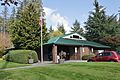
The Mill Creek library, operated by Sno-Isle Libraries
See also
 In Spanish: Mill Creek (Washington) para niños
