Image Lake
| Image Lake | |
|---|---|
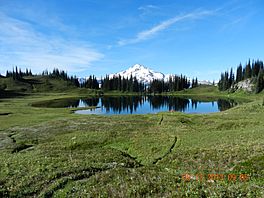
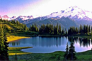
Image Lake as seen from near the inlet, with Glacier Peak in the background
|
|
| Location | Cascade Range, Snohomish County, Washington |
| Coordinates | 48°12′27″N 121°0′30″W / 48.20750°N 121.00833°W |
| Type | Tarn |
| Primary outflows | Miners Creek |
| Catchment area | Skagit River |
| Basin countries | United States |
| Surface area | 3–4 acres (1.2–1.6 ha) |
| Surface elevation | 6,056 ft (1,846 m) |
Image Lake is a beautiful mountain lake, also known as a tarn. You can find it in the Glacier Peak Wilderness area. This wilderness is part of the North Cascades mountains in Washington, United States.
The lake is surrounded by cool natural features. To the east, there's Plummer Peak. A great lookout point is to the west. To the south, you'll see the Miners Creek area and the huge Glacier Peak. Canyon Lake is located to the north. A popular hiking path, the Miners Ridge Trail, goes right by the lake. Many people love to take photos of Glacier Peak reflected in the lake's calm waters.
The area around Image Lake has a mild climate. It gets a lot of rain and snow. This helps create rich natural homes for many plants and animals. You can find insects, small rodents, and large mammals here. Long ago, Native Americans used these resources. They might have lived here during certain seasons.
Later, more people arrived, like Europeans. They hunted, fished, and mined in the area. This led to some damage to nature. For example, some large predator animals disappeared. Too many visitors and farm animals also caused problems. This was especially true in the early to mid-1900s.
Contents
Weather at Image Lake
Image Lake is in a marine west coast climate zone. This means it's near the ocean. Most weather systems start over the Pacific Ocean. They then move northeast towards the Cascade Mountains. These mountains surround Image Lake.
When weather systems hit the North Cascades, they are forced upwards. This makes them drop their moisture. So, the west side of the North Cascades gets a lot of rain or snowfall. This happens especially in winter. Because it's close to the Pacific Ocean, temperatures rarely go below 0 °F (−18 °C) or above 80 °F (27 °C).
In winter, it's usually cloudy. But in summer, high pressure systems form over the Pacific. This often brings clear skies. The snow here tends to be wet and heavy. This can create a high risk of avalanches.
Scientists expect global warming to affect this area. It could lead to droughts and more forest fires. Forests might also become less healthy. Salmon runs could also suffer. Plants and animals that live in high mountain areas might struggle. Glaciers are also expected to shrink. This is because of less snow and warmer temperatures.
Water Flow at Image Lake
Image Lake has a small area that collects water. It's less than 1 square mile (2.6 km2). The main stream flowing out of the lake is small and unnamed. It flows into Miners Creek. Miners Creek then drains into the Suiattle River. The Suiattle River eventually empties into Puget Sound.
The highest point in the lake's water collection area is almost 7,000 feet (2,100 m) high. The lake itself is mostly round. It covers an area of about 3–4 acres (1.2–1.6 ha).
How the Mountains Formed
The land around Image Lake started forming a long time ago. This was about 90 million years ago million years ago. Before that, it was an ocean area. It had mostly sedimentary and volcanic rocks. About 35 million years ago million years ago, many volcanoes became active.
But the mountains didn't start rising until about 10 million years ago million years ago. Image Lake is in a place called the Cloudy Pass batholith. This is a large rock formation that pushed up from deep underground. It formed about 20 million years ago million years ago.
Glacier Peak is a large volcano south of Image Lake. It began forming about 2.5 million years ago. Because Glacier Peak is so close, volcanic ash is common here. This ash is important for forming the soil.
During the ice age, thick glaciers covered the North Cascades. They reached almost to Puget Sound. The most ice was present about 18,000 years ago. Most valleys were free of ice by 12,000 years ago. Because of the glaciers, the valleys are deep and U-shaped. The mountains have steep slopes and narrow tops.
Plants and Trees
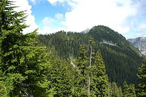
The area around Image Lake is part of the North Cascades ecoregion. At lower elevations, like in the Suiattle River valley, you'll find temperate rainforests. Common trees here include western redcedar, western hemlock, and Douglas fir.
At middle elevations, forests are mostly made of Pacific silver fir. You'll also see some Alaska cedar. Plants like Devil's club and huckleberry grow in wet spots. In drier areas, you'll find beargrass and salal. These mid-elevation forests get more rain and snow.
Higher up, Douglas fir and redcedar are replaced by mountain hemlock and Alaska cedar. These trees become more common as you go higher. The steepest mountain slopes often have avalanche paths. These paths usually have Sitka alder and other small shrubs and herbs.
At even higher elevations, mountain hemlock and subalpine fir are the most common trees. Whitebark pine and Alaska cedar are also present. The forest becomes broken up here. You'll see meadows with grasses, herbs, and shrubs. Scree slopes (loose rocks) are also common. Temperatures can change a lot in one day because of the high altitude.
At the very top of the tree line, trees are often small and twisted. This is due to strong winds and heavy snow. These trees are called "krummholz", which means "bent wood" in German. Heather, herbs, and grasses are also here, but they are very sparse.
Animals and Wildlife
Many different animals live in this area. Marmots live in big groups. They help control the plants in the high mountain areas. Eagles, hawks, coyotes, and badgers are common hunters. Clark's nutcrackers and Canada jays are also often seen. Different kinds of grouse birds live here too. Insects and hummingbirds help pollinate the plants.
Larger animals are not as common, but they are still around. A grizzly bear was seen near Cascade Pass in 2010. Up to twenty grizzlies might live in the Cascades. Wolves, pine martens, lynx, wolverines, weasels, and black bears are also present. They are often spotted by special cameras. In summer, bears eat a lot to get ready for hibernation. This eating phase is called hyperphagia. There have also been efforts to bring fishers back to the region.
Cougars are mostly active at night and live alone. They are very shy and rarely seen. Wolves were gone from the Cascades by the 1930s. But they started coming back and forming packs around 1990.
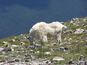
The most common large plant-eater is the black-tailed deer. This is a type of mule deer. Elk and moose are less common. Mountain goats are very good at living on steep, cold mountains. They are usually not found at lower elevations. Eight different kinds of bats also live in the North Cascades.
History of the Area
Evidence shows that Native Americans used this area for at least 8,500 years. They were at Cascade Pass even earlier, about 9,600 years ago. They hunted wild animals here. They also used a type of rock called obsidian for tools.
Native Americans used several paths through the region. They might have used the natural resources in summer. Some tribes saw the mountains as living beings. They included them in their beliefs. Many paths followed ridge tops. This helped them avoid thick bushes and avalanche areas in the valleys. Horses were also used in the 1700s.
There was a trail Native Americans used between Lake Chelan and the Suiattle River valley. This trail went over Cloudy Pass, east of Image Lake. Later, miners and shepherds used it in the early 1900s. Sheep grazing was stopped on Miners Ridge in 1940. But the area kept getting more popular.
Because so many people visited, the meadows around the lake got damaged. This was from farm animals grazing and people hiking off trails. So, farm animals were moved to a nearby area. Hardier plants were also brought to the lake area.
Image Lake was first called "Mirror Lake." But it got its current name on April 10, 1940. Hugh Ritter and Rudo Fromme, who worked for the US Forest Service, named it. The Forest Service first mapped the lake on July 14, 1939.
In 1988, a company called Kennecott Copper Corporation planned to dig a large copper mine. It was about a mile east of Image Lake. But groups like The Mountaineers protested. Their actions stopped the mining plan.
In 2003, floods damaged parts of the Suiattle River Road. This road leads to the trailhead. This made Image Lake harder to reach from the west. It became easier to get to from Holden or Trinity to the east.
As of August 2013, crews were fixing the road. It was supposed to open by 2014. But the Forest Service has a limited budget. Some environmental groups have criticized the road repair. This is partly because fewer visitors come now. Since it's hard to reach from the west, hikers often go from the east. This means a two-day hike from Holden or Trinity.
Hiking to Image Lake
You can reach the trail to Image Lake from the Suiattle River Road. You can also get there from Holden, which is east of the Cascade mountains. The trail first follows the Suiattle River. Then it opens up into meadows with great views of Glacier Peak.
There's also a high mountain path from the Miners Ridge Trail to Plummer Mountain. Another less used trail goes to Canyon Lake and Totem Pass. This pass is about 4 miles (6.4 km) southeast of Dome Peak.


