
Lassen Peak facts for kids
Quick facts for kids Lassen Peak |
|
|---|---|

Lassen Peak volcano
|
|
| Highest point | |
| Elevation | 10,457 ft (3,187 m) NAVD 88 |
| Listing | |
| Geography | |

Lassen Peak
Location in California

Lassen Peak
Location in the United States
|
|
| Location | Shasta County, California, U.S. |
| Parent range | Cascade Range |
| Topo map | USGS Lassen Peak |
| Geology | |
| Age of rock | Less than 27,000 years |
| Mountain type | Lava dome |
| Volcanic arc | Cascade Volcanic Arc |
| Last eruption | 1914 to 1921 |
| Climbing | |
| Easiest route | Hike |
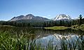
Lassen Peak, also known as Mount Lassen, is the southernmost active volcano in the Cascade Range in the western United States. It is located in Northern California and is part of the Cascade Volcanic Arc. This arc is a chain of volcanoes stretching from British Columbia to northern California. Lassen Peak stands tall at 10,457 ft (3,187 m) above the northern Sacramento Valley. It is home to many plants and animals and gets a lot of snow.
Lassen Peak is a type of volcano called a lava dome. It is the largest lava dome on Earth, with a volume of 0.6 cu mi (2.5 km3). The volcano formed about 27,000 years ago from a series of eruptions. It grew from the side of an older, collapsed volcano called Mount Tehama. Over the last 25,000 years, glaciers have worn down the mountain. Now, it is covered in loose rock called talus.
On May 22, 1915, Lassen Peak had a very powerful explosive eruption. This eruption caused damage to nearby areas. It also sent volcanic ash as far as 280 mi (450 km) to the east. This was the strongest eruption in a series that lasted from 1914 to 1917. Lassen Peak and Mount St. Helens were the only two volcanoes in the contiguous United States to erupt in the 1900s.
Lassen Volcanic National Park was created to protect the areas affected by the eruption. The park covers 106,372 acres (430.47 km2). It helps scientists study the volcano and keeps people safe from future eruptions. The park, along with the nearby Lassen National Forest, is a popular spot for outdoor fun. People enjoy climbing, hiking, backpacking, snowshoeing, kayaking, and backcountry skiing. Lassen Peak is still considered an active volcano. This means it is just sleeping and could erupt again. It has a working magma chamber underground. Because of this, it could cause dangers like lava flows, pyroclastic flows, lahars (volcanic mudslides), ash, avalanches, and floods. Scientists at the California Volcano Observatory watch Lassen Peak closely with special sensors.
Contents
Where is Lassen Peak Located?

Lassen Peak is found inside Lassen Volcanic National Park. It is in Shasta County, about 55 mi (89 km) east of Redding. The park area is surrounded by the Lassen National Forest, which is very large. Nearby towns include Mineral and Viola.
Lassen Peak is about 10,457 ft (3,187 m) tall. It is the southernmost major volcano in the Cascade Range. It rises high above the northern Sacramento Valley. It is the second-tallest peak in the California Cascades. Only Mount Shasta, which is 80 mi (130 km) north, is taller. Lassen Peak is close to other volcanoes like Mount Tehama and Mount Diller. This makes it sometimes hard to tell them apart.
Weather and Snowfall at Lassen Peak
Lassen Peak gets the most winter snowfall in California. On average, it gets 660 in (1,676 cm) of snow each year. Some years, over 1,000 in (2,500 cm) of snow falls at its base. This is more precipitation (rain, sleet, hail, snow) than anywhere else in the Cascade Range south of Oregon's Three Sisters volcanoes.
Even though it is not tall enough for a permanent ice cap, the heavy snowfall creates fourteen patches of snow that last all year. However, there are no glaciers on Lassen Peak.
Lightning often strikes the area during summer thunderstorms. These strikes can start fires. In 2012, a lightning strike caused the Reading Fire. This fire burned a large area. The National Park Service sometimes sets controlled fires to reduce wildfire risks.
Plants and Animals of Lassen Peak
Lassen Peak is home to many different plants. These include mountain hemlock, whitebark pine, and alpine wildflowers. Mountain hemlocks usually grow up to 9,200 ft (2,800 m). Whitebark pines can reach 10,000 ft (3,000 m).
In the national park, you can find forests with red fir, mountain alder, western white pine, white fir, lodgepole pine, Jeffrey pine, ponderosa pine, incense cedar, juniper, and live oak. Other plants include coyote mint, lupines, mule's ears, and ferns.
The park's different environments support about 300 types of vertebrate animals. These include mammals, reptiles, amphibians, fish, and birds. Some important birds are bald eagles and peregrine falcons.
- Forest Animals: Below 7,800 ft (2,400 m), you might see American black bears, mule deer, martens, and several bat species.
- Higher Elevation Animals: At higher spots, Clark's nutcrackers, deer mice, and chipmunks live among the mountain hemlocks. In areas with less plants, you can find gray-crowned rosy finches, pikas, and golden-mantled ground squirrels.
- Meadow Animals: Valleys with streams and lakes have Pacific tree frogs, Western terrestrial garter snakes, and mountain pocket gophers.
- Other Animals: The park also has snakes like rubber boas and striped whipsnakes. You might also find cougars, newts, and Cascades frogs. There are 216 types of birds, including spotted owls and bufflehead ducks. Five types of native fish live here, like rainbow trout. Some invasive fish like brook trout are also present. A common invertebrate is the California tortoiseshell butterfly.
How Lassen Peak Formed

Lassen Peak is at the southern end of the Cascade Volcanic Arc. This arc is formed because the Juan de Fuca Plate is sliding under the North American tectonic plate. This process creates magma that feeds the volcanoes.
About 3 million years ago, volcanoes were active further south. Now, the active area has moved north. This shows that the Cascade Arc's southern end is slowly shifting.
The Lassen area has had many eruptions over the past 3 million years. In the past 825,000 years, hundreds of explosive eruptions have happened. The last 50,000 years saw seven big eruptions that created dacitic lava domes.
The volcano called Brokeoff Volcano (or Mount Tehama) started forming 600,000 years ago. Around the same time, a huge eruption southwest of Lassen Peak created a lot of pumice and ash. This ash spread far across the land. This eruption also formed a large bowl-shaped hole called a caldera.
.jpg)
Lassen Peak's lava dome itself formed about 27,000 years ago. It grew from a series of eruptions over a few years. Between 25,000 and 18,000 years ago, glaciers significantly shaped the mountain. The bowl-shaped area on its northeast side, called a cirque, was carved by a glacier. As the lava dome grew, it broke apart the rock above it. This created a layer of angular talus around the volcano. Lassen Peak likely reached its current height very quickly, possibly in just a few years.
Lassen Peak is a rhyodacitic lava dome. It is one of the largest lava domes on Earth. It rises 2,000 ft (610 m) above the land around it. Unlike cone-shaped volcanoes, Lassen Peak is part of a group of volcanoes that erupt from different spots. Each spot is active for a while, but they often don't erupt from the same place twice. This is called a monogenetic volcanic field.
Other Volcanic Features Nearby

The Lassen volcanic area has many features. These include Brokeoff Volcano, Lassen Peak, and smaller volcanoes called shield volcanoes. There are also 30 other dacitic lava domes, like Bumpass Mountain and Chaos Crags. Nearby are three cones: Cinder Cone, Hat Mountain, and Raker Peak.
The Chaos Crags are a group of five small lava domes. They are the youngest part of the Lassen volcanic area. They formed from powerful explosive eruptions. About 350 years ago, one of these domes collapsed. This caused huge rockfalls called the Chaos Jumbles. These rockfalls traveled 4 mi (6.4 km) down the slopes.
Cinder Cone is a cone-shaped volcano in the park's northeast. It is the youngest volcano of its kind in the area. It is surrounded by rough lava. In the 1850s, some people reported seeing an eruption at Cinder Cone. However, scientists from the United States Geological Survey doubt these reports. There is no physical evidence of activity since it formed in 1650. Also, a willow bush that was there in the 1850s was still there in the 1880s, suggesting no eruption happened.
Human History of Lassen Peak

The area around Lassen Peak was a meeting place for several Native American groups. These included the Maidu, Yana, Yahi, and Atsugewi peoples. Some native groups called the volcano Amblu Kai, meaning "Mountain Ripped Apart" or "Fire Mountain." The Mountain Maidu called it Kom Yamani, meaning "Snow Mountain."
The first white person to see Lassen Peak was Jedediah Smith in 1821. After the California Gold Rush, more settlers came. Lassen Peak was named after Peter Lassen, a Danish blacksmith. He guided immigrants past the peak in the 1830s.
The first recorded climb of Lassen Peak was in 1851. In 1864, Helen Tanner Brodt became the first woman to reach the top. A lake on the mountain, Lake Helen, is named after her. Another area, Bumpass Hell, is named after a pioneer who was burned there.
Lassen Volcanic National Park
In 1907, U.S. President Theodore Roosevelt created the Lassen Peak National Monument. At that time, people thought Lassen Peak was no longer active. They wanted to protect the interesting volcanic features. But when the volcano became active again in 1914, the monument was made bigger. On August 9, 1916, it became Lassen Volcanic National Park. The park covers 106,372 acres (430.47 km2) and can be reached by California State Route 89.
Eruptions of Lassen Peak

Past Eruptions
Over the past 300,000 years, the Lassen Peak area has created more than 30 lava domes. Lassen Peak is the largest of these. These domes formed when thick lava was pushed up but could not flow out easily.
Before 1914, Lassen Peak likely had at least one big explosive eruption. This created a deep crater at its top.
The 1914–1921 Eruptions
On May 30, 1914, Lassen Peak woke up after 27,000 years of being quiet. It had a steam explosion that made a small crater at its summit. Over the next 11 months, more than 180 similar steam explosions happened. The crater grew to 1,000 ft (300 m) long.
On May 14, 1915, Lassen Peak erupted lava blocks. The next day, a new lava dome formed in the summit crater. On May 19, a large eruption destroyed this dome. Parts of the dome fell onto the mountain's snowy sides. The lava mixed with snow and rock to form a lahar (volcanic mudslide). This lahar was 0.5 mi (0.80 km) wide and traveled 4 mi (6.4 km) down the volcano. It reached Hat Creek and then went another 7 mi (11 km) down Lost Creek. On May 20, the Hat Creek valley flooded, damaging homes and causing minor injuries.
.jpg)
On May 22, 1915, Lassen Peak had a very strong explosive eruption. It shot out rock and pumice. A column of volcanic ash and gas rose over 30,000 ft (9,100 m) high. This column could be seen from 150 mi (240 km) away. Part of the column collapsed, creating a hot pyroclastic flow. This flow destroyed 3 sq mi (7.8 km2) of land. It also caused another lahar that went 15 mi (24 km) from the volcano. Volcanic ash fell as far as 280 mi (450 km) to the east.
The area destroyed on the volcano's northeast side is now called the Devastated Area. Plants here are sparse because the soil is poor.
After 1915, steam explosions continued for several years. This showed that very hot rock was still under Lassen Peak. In May 1917, a strong steam explosion created a new crater. Eruptions continued until 1921. In total, about 400 eruptions were seen between 1914 and 1921. These were the last eruptions in the Cascades until the 1980 eruption of Mount St. Helens.
Documenting the Eruptions
Lassen Peak's eruptions in the early 1900s got a lot of attention. They were the first volcano eruptions in the U.S. during that century. Newspapers covered them widely, and many photos were taken. Benjamin Franklin Loomis, a local businessman, took some of the best pictures. He even made his own film and set up a darkroom in a tent. His photos helped scientists understand the eruptions.
One of the 1917 eruptions was even captured on film by Justin Hammer. This film was later rediscovered and published in 2015.
Current Activity and Dangers


Lassen Peak is still an active volcano. You can find steam vents (fumaroles), hot springs, and mudpots throughout Lassen Volcanic National Park. Their activity changes with the seasons. In spring, they are cooler due to meltwater. In summer, they become hotter and drier. These features are caused by boiling underground water.
The most active area is Bumpass Hell. Here, temperatures can reach 322 °F (161 °C). The Big Boiler is the park's largest fumarole. These hot, acidic areas are not safe for bathing. Fumaroles near Lassen Peak were active until the 1950s but have since become weaker. Scientists continuously monitor these features.
Even after 1921, climbers reported steam eruptions at the summit for decades. The United States Geological Survey says that "it is almost certain that the Lassen area will experience volcanic eruptions again." The California Volcano Observatory lists its threat level as "Very High."
When Lassen Peak erupted in the early 1900s, few people lived nearby. Today, an eruption could affect many lives and the economy of northern California. Volcano eruptions happen as often as major earthquakes in California. At least 10 eruptions have occurred in the state in the last 1,000 years.
If there are signs of an eruption, the United States Geological Survey has a plan. They will use special equipment and send scientists to the area. The National Park Service also has an emergency plan ready.
Lava flows are common in the Lassen area. But more dangerous eruptions could also happen. These could create new, unstable lava domes that might collapse. This could cause pyroclastic flows that travel for miles. Because Lassen Peak has a lot of snow and ice, these hot flows could mix with water. This would create lahars (volcanic mudslides) that could harm nearby towns. Explosive eruptions could also send ash high into the sky, which could be dangerous for airplanes.
Visitors to the park also face dangers from sudden avalanches, even without an eruption. Due to the risk of avalanches from Chaos Crag, the Visitor Center at Manzanita Lake closed in 1974. In 1993, a large rockfall happened on Lassen Peak, but no one was hurt. Even when the volcano is quiet, falling rocks are still a danger.
The California Volcano Observatory watches the volcano. They use sensors to detect earthquakes, ground changes, or gas releases. These could mean magma is moving underground. The United States Geological Survey uses special tools like tiltmeters and seismometers to monitor Lassen Peak. Since 1996, studies have shown that the ground around Lassen Peak is sinking slightly. This sinking might give clues about how magma is stored and how the area's hot springs work.
Fun Activities at Lassen Peak

More than 350,000 people visit Lassen Volcanic National Park every year. The park has over 150 mi (240 km) of hiking trails. In summer, people enjoy hiking and backpacking. In winter, popular activities include snowshoeing and backcountry skiing.
Lassen Peak is the second-tallest volcano in Northern California. Many climbers and hikers visit it. The summit trail usually opens in late June and closes when heavy snow falls in October or November. The trail was closed for six years for repairs after an accident in 2009. It reopened in 2015.
You can reach the summit trail from a parking lot on California State Route 89. The Lassen Peak Trail is 2.5 mi (4.0 km) long one way. It has switchback turns and climbs about 2,000 ft (610 m). From the top, you can see Lassen's 1915 mudflow and Prospect Peak. You can also see Mount Shasta, 80 mi (130 km) to the north.
The park's southern entrance has a winter sports area. Here, visitors can ski and snowshoe. In the Lassen National Forest, you can also bike, go boating, or use snowmobiles.
Images for kids
-
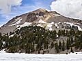
Lassen Peak volcano
-
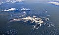
Aerial view of Mount Lassen with snow, early May 2018
-
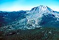
Lassen Peak's northeastern face
-
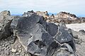
Dacitic volcanic rock on Lassen Peak's summit
-
The Chaos Crags and Lassen Peak, as seen from Manzanita Lake
-

The Lassen Peak National Monument, later expanded into Lassen Volcanic National Park, was established by United States President Theodore Roosevelt (pictured) in 1907.
-
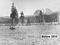
Lassen Peak Before 1914
-
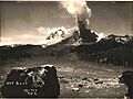
The "Great Explosion" eruption column of May 22, 1915 was seen as far as 150 mi (240 km) away. In the foreground is the Loomis Hot Rock, one of the many large boulders dislodged in the eruption that were too hot to touch for days after. (Photograph by B. F. Loomis; modern photo)
-
Lassen Volcanic National Park has an extensive hydrothermal system that includes fumaroles, hot springs, and mudpots.
-
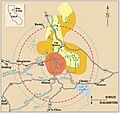
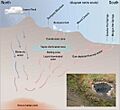
A volcanic hazard map for Lassen Peak made by the United States Geological Survey.
-
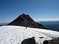
Snow covered summit of Lassen Peak
See also
 In Spanish: Pico Lassen para niños
