Mount Cayley massif facts for kids
Quick facts for kids Mount Cayley massif |
|
|---|---|

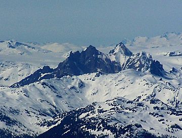
The Mount Cayley massif as seen from the southeast. Summits left to right are Pyroclastic Peak, Mount Cayley and Wizard Peak.
|
|
| Highest point | |
| Peak | Mount Cayley |
| Elevation | 2,385 m (7,825 ft) |
| Geography | |
| Country | Canada |
| Province | British Columbia |
| District | New Westminster Land District |
| Range coordinates | 50°06′58″N 123°17′15″W / 50.11611°N 123.28750°W |
| Parent range | Pacific Ranges |
| Topo map | NTS 92J/12 |
| Geology | |
| Formed by | Stratovolcano, lava domes |
| Age of rock | Neogene-to-Quaternary |
| Volcanic arc/belt | Canadian Cascade Arc Garibaldi Volcanic Belt |
| Climbing | |
| First ascent | 1928 by E. C. Brooks, W. G. Wheatley, B. Clegg, R. E. Knight and T. Fyles |
The Mount Cayley massif is a group of mountains in southwestern British Columbia, Canada. It is about 45 km (28 mi) north of Squamish. It is also about 24 km (15 mi) west of Whistler. This mountain group sits near the Powder Mountain Icefield.
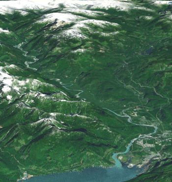
The massif is an old stratovolcano that could still be active. It stands tall over the Cheakamus and Squamish river valleys. All its main peaks are taller than 2,000 m (6,600 ft). Mount Cayley is the tallest at 2,385 m (7,825 ft). People have lived in this area for over 7,000 years.
The Mount Cayley massif is part of the Garibaldi Volcanic Belt. It formed because of subduction zone volcanism. This is when one of Earth's plates slides under another. The volcano started erupting about 4 million years ago. It has grown in three main stages since then. The last big eruptions happened within the last 400,000 years. Some smaller activity continues even now.
Scientists believe future eruptions could happen. These might threaten nearby towns. Dangers include pyroclastic flows (fast-moving hot gas and rock) and lahars (volcanic mudslides). Floods and landslides are also possible. The Geological Survey of Canada (GSC) watches the volcano closely. This helps them monitor any threats.
Contents
Mount Cayley's Location and Rocks
The Mount Cayley massif is in the middle of the Mount Cayley volcanic field. This area has many volcanoes that formed under ice during the Late Pleistocene Ice Age. Some of these, like Pali Dome and Slag Hill, were active more recently. The Mount Cayley volcanic field is part of the Garibaldi Volcanic Belt. This belt is an extension of the Cascade Volcanic Arc. These volcanoes form because the Juan de Fuca Plate slides under the North American Plate. This happens at the Cascadia subduction zone.
The Mount Cayley massif has three main peaks. Mount Cayley is the highest and most northern. It is 2,385 m (7,825 ft) tall. Its side touches the southern end of the Powder Mountain Icefield. This icefield is a glacier about 9 km (5.6 mi) long and 5 km (3.1 mi) wide.
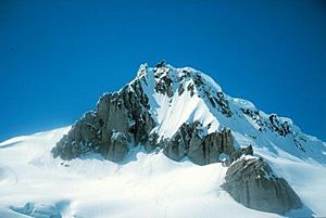
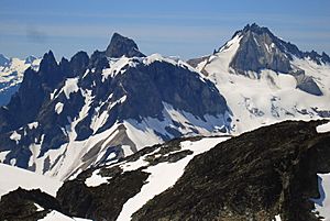
Southwest of Mount Cayley is Pyroclastic Peak. It is 2,341 m (7,680 ft) tall. It has a jagged top with many thin rock pinnacles. The biggest one is called the Vulcan's Thumb. East of Pyroclastic Peak is Wizard Peak. It is 2,240 m (7,350 ft) tall and is the lowest of the three main peaks.
As a stratovolcano, Mount Cayley is made of hardened lava and ash. These layers built up from many volcanic eruptions. The rocks are mostly dacitic and rhyodacite. These are types of volcanic rock. The volcano used to be much bigger. But erosion by glaciers has worn it down. Today, it is estimated to be about 8 km3 (1.9 cu mi) in size. Several creeks flow from the massif's slopes. These include Turbid Creek, Dusty Creek, Avalanche Creek, and Shovelnose Creek.
Scientists have looked deep under the massif. About 12.5 to 13 km (7.8 to 8.1 mi) down, they found a "bright spot." This spot likely means there is a magma chamber or very hot rock deep in the Earth's crust.
Mount Cayley's Volcanic Past
The Mount Cayley massif has erupted many times over the last 4 million years. This makes it one of the most active volcanoes in the Garibaldi Volcanic Belt. Scientists have found three main stages of eruptions.
The first two stages, called the Mount Cayley and Vulcan's Thumb stages, happened between 4 million and 600,000 years ago. During these times, the main volcano and lava domes were built. Then, there was a quiet period for 300,000 years. During this time, erosion wore away much of the original volcano.
The third stage, called the Shovelnose stage, happened about 300,000 to 200,000 years ago. New lava domes and flows formed during this stage. Some rocks from this stage might be much younger, perhaps less than 15,000 years old.
The eruptions produced different types of volcanic rocks. These included andesite, dacite, and rhyodacite. There is no sign that the Mount Cayley massif erupted when it was covered by ice. This is different from many other volcanoes nearby.
The first eruptions of Mount Cayley 4 million years ago happened when Earth's plates in the area changed how they moved. This led to the creation of the younger Garibaldi Volcanic Belt.
Mount Cayley Stage (Early Eruptions)
In the early Mount Cayley stage, lava flows and pyroclastic rocks erupted. These rocks formed on top of older, solid rock. The first eruptions created layers of dacite flows and ash. These layers were cut by dikes and sills. These rocks are now light yellow or red. You can see them well on the massif's southwestern cliffs.
Later, thick dacite flows up to 150 m (490 ft) formed. These flows make up the top and northern side of Wizard Peak. This stage ended with a central lava dome. This dome forms the narrow, jagged top of Mount Cayley.
Vulcan's Thumb Stage (Next Eruptions)
The next period of eruptions, the Vulcan's Thumb stage, built a new part of the volcano. This part grew on the southwest side of the older Mount Cayley volcano. It started with large dacite flows and rocky breccias. These rocks formed on top of the older rocks. They now make up a ridge south of Wizard Peak. They also form the sharp peaks of Pyroclastic Peak, including the Vulcan's Thumb.
Later, a large area of loose ash and small rock fragments formed. This area is about 1 km (0.62 mi) wide and 4 km (2.5 mi) long. It has been worn away by erosion, forming steep cliffs. This stage also created a 130 m (430 ft) thick layer of dacitic tuff breccia. This layer is found between Wizard Peak and Mount Cayley.
Shovelnose Stage (Final Major Eruptions)
The last main stage of volcanic activity was the Shovelnose stage. Two lava domes erupted on the east and southeast sides of the massif. These were in the upper Shovelnose Creek valley. The southeast dacite dome formed 400 m (1,300 ft) high cliffs. It was the source of a 5 km (3.1 mi) long dacite flow. This flow went down the Shovelnose and Turbid creek valleys. The east lava dome formed on top of older ash layers. It is a steep-sided mass of dacite.
Recent Activity (Still Active?)
Mount Cayley has not erupted in recorded history. However, some low-level activity continues today. Small earthquakes have happened nearby since 1985. Also, the Shovelnose and Turbid creek valleys have hot springs. The GSC considers the massif a potentially active volcano. The hot springs have temperatures from 18 to 40 °C (64 to 104 °F).
The hot springs show that there is still magmatic heat underground. There are also deposits of tufa and sinter around the hot springs. These are minerals left behind by the hot water. Bright red ochre also forms from some cold water seeps. These springs are found near dacite cupolas and dikes. These formed during the Vulcan's Thumb stage.

Landslides and Their History
The Mount Cayley massif has many loose volcanic rocks. Some of these have been changed by hot water. This makes the area very likely to have debris avalanches (fast-moving landslides). At least three big debris avalanches have happened on the western side in the last 10,000 years. All of them blocked the Squamish River. This created temporary lakes upstream.
The first and largest event was about 4,800 years ago. It created a huge fan of debris along the Squamish River. This fan was 200,000,000 to 300,000,000 m3 (7.1×10⁹ to 1.06×10¹⁰ cu ft) in size. Another big debris avalanche happened about 1,100 years ago. The third event was about 500 years ago. It was the smallest of the three big prehistoric landslides.
At least three smaller landslides have happened in more recent times. In 1963, a 5,000,000 m3 (180,000,000 cu ft) landslide occurred. A large volcanic rock slid into Dusty Creek. It broke apart and traveled about 1 km (0.62 mi) downstream. Both Dusty Creek and Turbid Creek were blocked. This created lakes that later overflowed. This caused floods and possibly more debris flows.
In June 1984, a major rockslide and debris flow happened. It was a 3,200,000 m3 (110,000,000 cu ft) collapse at the top of Avalanche Creek. The debris flow reached Turbid Creek. It destroyed a bridge and blocked the Squamish River. In June 2014, another debris flow happened along Turbid Creek. It removed part of the Squamish River Forest Service Road.
Human History and Culture
First Nations people have lived in this area for thousands of years. The Squamish people call the Mount Cayley massif and The Black Tusk tak'takmu'yin tl'a in7in'axa7en. In their language, this means "Landing Place of the Thunderbird". The Thunderbird is a special creature in North American indigenous peoples' stories. When it flaps its wings, it makes thunder. Lightning comes from its eyes. The Mount Cayley massif and The Black Tusk are sacred to the Squamish people. They are important to their history.
The Squamish people gathered berries on and near the massif. These included mountain bilberries and oval-leaved blueberries. These were a favorite food. Glassy rhyodacite from the slopes has been found at old hunting sites. This rock was used for tools.
The first people to climb the massif were from the Alpine Club of Canada. This happened in July 1928. The group included mountaineers R. E. Knight, W. G. Wheatley, E. C. Brooks, T. Fyles, and B. Clegg. T. Fyles suggested naming the mountain after Beverley Cochrane Cayley. She was a friend who had died that year. The name became official on April 2, 1929.
People have also explored the Mount Cayley massif for geothermal energy. This is energy from the Earth's heat. This exploration started in the late 1970s. Scientists drilled holes to measure heat underground. They found high temperatures. In 2002, BC Hydro said Mount Cayley was one of the best places for a geothermal power station. It could produce 100 megawatts of power. However, the rough land makes it hard and costly to build there.
Volcanic Dangers
Even though Mount Cayley is quiet now, it still poses dangers. These dangers could affect nearby towns and logging areas. Data from the GSC suggests there is still magma inside the volcano. This means future eruptions are possible. These could lead to volcanic hazards like landslides. In 2000, GSC scientists created a plan to show how dangerous an eruption could be.
If the volcano starts to erupt again, scientists would likely see more seismicity (earthquakes). This happens as magma moves through the Earth's crust. The existing Canadian National Seismograph Network would detect these changes. This would alert the GSC to increase monitoring. As magma gets closer to the surface, the volcano might swell. The ground could crack, making hot springs more active. New hot springs or fumaroles (steam vents) might appear.
Small and even large landslides could happen. These might temporarily block the Squamish River. This has happened before, even without earthquakes. Eventually, magma near the surface could cause explosions. These are called phreatic explosions. They can also cause debris flows. If this happens, Highway 99 would close. Squamish would be evacuated. Whistler might also need to be evacuated.
If there is an explosive eruption, a cloud of ash could go 20 km (12 mi) high. This cloud could last for 12 hours. Airplanes would have to avoid the area. Airports covered by the ash cloud would close. This includes airports in Vancouver, Victoria, Kamloops, Prince George, and Seattle.
Near the volcano, the eruption cloud would collapse. This would form pyroclastic flows. These would rush into the Squamish and Cheakamus valleys. They would quickly melt snow and ice. This would create debris flows that could reach Squamish and Daisy Lake. They would damage buildings and roads. Heavy ash falls would happen in Vancouver, the Fraser Valley, Bellingham, Kamloops, Whistler, and Pemberton.
The ash would damage power lines, communication lines, and electronic equipment. Phones and internet would stop working. Buildings might collapse from the weight of the ash. The ash cloud would then spread across the west coast. It could reach from Seattle to Anchorage. This would close all airports in that area. Flights would be canceled or rerouted. The ash cloud would also move east across Canada. This would disrupt air travel from Alberta to Newfoundland and Labrador.
Smaller explosions might continue. They would create ash plumes 10 to 15 km (6.2 to 9.3 mi) high. Small pyroclastic flows would go into the Squamish and Cheakamus valleys. Ash plumes would go north and east.
Eventually, the explosions might stop. A lava dome would slowly grow in the new crater. Rain and melting snow would mix with the ash. This would create lahars (mudflows). These would continue to threaten the Squamish and Cheakamus valleys. The hardening lava could also cause rockfalls. These would form a large pile of rocks in the Squamish valley. As the lava dome grows, parts of it might collapse. This would create dense pyroclastic flows. Ash from these flows would form plumes up to 10 km (6.2 mi) high. This would drop ash on Pemberton and Whistler. It would also disrupt local air traffic.
The eruption could last for years. After that, there would be years of less intense activity. The cooling lava would still cause pyroclastic flows. Loose rock and ash on the slopes would turn into debris flows. A lot of work would be needed to fix Highway 99 and the Squamish area.
 | Delilah Pierce |
 | Gordon Parks |
 | Augusta Savage |
 | Charles Ethan Porter |


