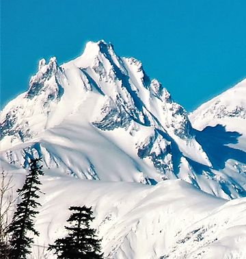
Mount Meager (British Columbia) facts for kids
Quick facts for kids Mount Meager |
|
|---|---|

Southeast aspect
|
|
| Highest point | |
| Elevation | 2,650 m (8,690 ft) |
| Prominence | 220 m (720 ft) |
| Listing | Mountains of British Columbia |
| Geography | |
| District | Lillooet Land District |
| Parent range | Pacific Ranges |
| Topo map | NTS 92J12 Mount Dalgleish |
| Geology | |
| Volcanic arc/belt | Canadian Cascade Arc Garibaldi Volcanic Belt |
| Last eruption | Pleistocene age |
| Climbing | |
| First ascent | 1931 N. Carter; A. Dalgleish; T. Fyles; M. Winram |
Mount Meager is a tall mountain in British Columbia, Canada. It is also known as The Cathedral. In the St'at'imcets (Lillooet) language, it is called Q̓welq̓welústen. This mountain is part of the Pacific Ranges of the Coast Mountains.
Mount Meager is actually the second highest peak in a group of volcanoes. This group is called the Mount Meager massif. These volcanoes are a type called stratovolcanoes. A stratovolcano is a tall, cone-shaped volcano. It is built up by many layers of hardened lava, ash, and rocks. Mount Meager is part of the Garibaldi Volcanic Belt. This is an area in Canada with many volcanoes.
The Big Landslide of 2010
Mount Meager was the location of a very large landslide in 2010. On August 6, 2010, a part of the mountain's southern peak broke off. This happened as a series of huge rockfalls. These rocks then turned into a fast-moving flow of mud and debris.
This large flow of debris blocked Meager Creek. It created a temporary dam about 30 meters (98 feet) high. This dam caused a temporary lake to form. The lake was about 4 kilometers (2.5 miles) long. The debris flow also crossed the Lillooet River downstream. It even destroyed a forestry road on the other side of the Lillooet River.
Emergency workers were worried the dam on Meager Creek might break suddenly. Because of this, people living nearby were asked to leave their homes. Residents in the village of Pemberton, about 55 kilometers (34 miles) downstream, had to evacuate. People in the Lil'wat community at Mount Currie also had to leave the area.
See also
 In Spanish: Macizo Mount Meager para niños
 | Leon Lynch |
 | Milton P. Webster |
 | Ferdinand Smith |


