Interior Plateau facts for kids
Quick facts for kids Interior Plateau |
|
|---|---|

|
|
| Location | British Columbia and Washington |
| Coordinates | 52°00′00″N 123°00′00″W / 52.00000°N 123.00000°W |
| Part of | Intermontane Plateaus |
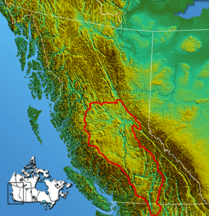
The Interior Plateau is a huge area in British Columbia, Canada. It sits between tall mountain ranges. To the east, you'll find the Cariboo and Monashee Mountains. To the west are the Hazelton Mountains, Coast Mountains, and Cascade Range.
This plateau also stretches into the United States. There, it's known as the Columbia Plateau. Think of the Interior Plateau as a big, flat-ish land that's part of an even bigger area called the Intermontane Plateaus.
Contents
Parts of the Interior Plateau
The Interior Plateau is made up of several smaller regions. Each has its own unique features:
- The Fraser Plateau
- The Chilcotin Plateau
- The Cariboo Plateau
- The Bonaparte Plateau (sometimes called the Kamloops Plateau)
- The Nechako Plateau
- The McGregor Plateau
- The Thompson Plateau
The Fraser River acts like a natural border. It separates the Cariboo and Chilcotin Plateaus. The Nechako Plateau is found on both sides of the Fraser River. Its southern edge is marked by the West Road River and the Quesnel River. To the north, it meets the Omineca Mountains and the Cassiar Mountains.
Mountains and Hills in the Plateau
Even though it's called a plateau, this region has many mountain ranges and hill systems. Here are some of them:
- The Pavilion Range includes:
- The Clear Range (with the Scarped Range)
- The Marble Range
- The Cornwall Hills (next to the Clear Range)
- The Trachyte Hills (next to the Clear and Marble Ranges)
- The Arrowstone Hills (on the edge of the Bonaparte Plateau)
- The Rainbow Range (sometimes linked to the Coast Mountains)
- The Itcha Range
- The Ilgachuz Range
- The Quanchus Range (on the western edge of the Nechako Plateau)
- The Telegraph Range (Nechako Plateau)
- The Fawnie Range (Nechako Plateau)
- The Pattullo Range (sometimes seen as part of the Hazelton Mountains)
Some areas are on the edge of the plateau. They are sometimes considered part of it, or part of the nearby mountain ranges. These include the Shuswap Highland, Okanagan Highland, and Quesnel Highland.
A Look Back in Time
The Interior Plateau is located in North America, between the Rocky Mountains and the Pacific Coast Ranges. Two major rivers, the Columbia and the Fraser, flow through it.
The northern part of the plateau is mostly covered in forests. But in lower and more southern areas, you'll find dry grasslands with sagebrush, similar to the southern part of the plateau in the Columbia River area.
Early Human Life
People have lived in the Interior Plateau for a very long time. The first signs of humans date back to 8500 BC. Scientists have found Bison bones and special stone tools called Clovis points from this period. An important discovery site is in Wenatchee, Washington.
The Windust phase was a time between 10600 BC and 7100 BC. At the Lind Coulee Archaeological Site in Washington, archaeologists found leaf-shaped tools and knives from 8500 to 5500 BC. These early people were hunters. They also got food by fishing and gathering plants. Finding sea shells suggests they traded with other groups. A small, oval-shaped home was also found at the Paulina Lake site in Oregon, dating to 7100 BC.
Changes Over Time
The Cascade phase happened from 7100 to 4300 BC. During this time, the tools people used changed a little. A residential structure was found from this period, dating between 5500 and 4300 BC. More pit-houses (homes dug partly into the ground) appeared between 4000 and 2000 BC. Most of these homes were built near rivers. In later times, salmon and plants were the main foods. This tells us that people likely caught salmon during the summer and fall.
The Late Period began around 2500 BC. This is when the pit-house, also known as a quiggly hole, became common. Many pit-houses and settlements from this time have been found, like at the Keatley Creek Archaeological Site. Fishing became even more important, and technology improved. People started using special barbed fish spears and harpoons. They also used nets and weirs (fish traps). Trade networks grew, with people exchanging sea shells, turquoise, and fish grease.
See also
 In Spanish: Meseta Interior para niños
 | Tommie Smith |
 | Simone Manuel |
 | Shani Davis |
 | Simone Biles |
 | Alice Coachman |

