Fraser Plateau facts for kids
Quick facts for kids Fraser Plateau |
|
|---|---|

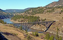
Fraser Canyon southwest of Williams Lake
|
|
| Location | British Columbia, Canada |
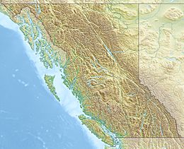
| Coordinates | 52°00′00″N 123°00′00″W / 52.00000°N 123.00000°W |
| Part of | Interior Plateau |
| Geology | Flood basalt |
The Fraser Plateau is a large, flat area of land in the middle of British Columbia, Canada. It's like a big, high tableland located between mountains. It is part of an even bigger area called the Interior Plateau.
Exploring the Fraser Plateau
The Fraser Plateau is a huge region. It includes two other large flat areas: the Cariboo Plateau and the Chilcotin Plateau. On its southwestern side, you'll find mountain ranges like the Marble Range, Clear Range, and Camelsfoot Range.
Where is it Located?
The Fraser Plateau has clear boundaries. To its southeast, it's separated by the Bonaparte River from the Bonaparte or Kamloops Plateau. This area is part of the Thompson Plateau. To the northwest, a line formed by the Dean River and West Road River marks its edge. The Nechako Plateau is located north of the West Road River.
The Fraser Plateau also includes the Itcha Range and Ilgachuz Range. These ranges are next to the Rainbow Range, which is near the Coast Mountains.
How the Fraser Plateau Formed
The Fraser Plateau is made up of a type of rock called basalt. This basalt came from ancient lava flows. These lava flows are part of something called the Chilcotin Group. This group is made of volcanic rocks that are very similar to the Fraser Plateau itself. Imagine huge amounts of liquid rock flowing out and cooling to form this flat, high land!
See also
 In Spanish: Meseta Fraser para niños
 | George Robert Carruthers |
 | Patricia Bath |
 | Jan Ernst Matzeliger |
 | Alexander Miles |


