Itcha Range facts for kids
Quick facts for kids Itcha Range |
|
|---|---|
| Itcha Mountains Itchas |
|
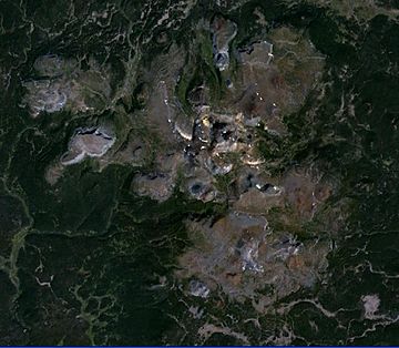
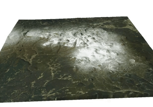
Satellite image of the Itcha Range
|
|
| Highest point | |
| Peak | Mount Downton |
| Elevation | 2,375 m (7,792 ft) |
| Geography | |
| Country | Canada |
| Province | British Columbia |
| District | Range 3 Coast Land District |
| Range coordinates | 52°40′00″N 124°50′00″W / 52.66667°N 124.83333°W |
| Parent range | Chilcotin Plateau |
| Borders on | Ilgachuz Range |
| Topo map | NTS 93C/10 |
| Geology | |
| Formed by | Shield volcano |
| Orogeny | Anahim hotspot |
| Age of rock | Neogene-to-Quaternary |
| Type of rock | Igneous |
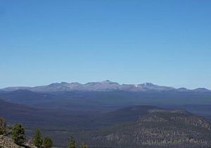
The Itcha Range, also known as the Itchas, is a small group of mountains in British Columbia, Canada. It is located about 40 km (25 mi) northeast of Anahim Lake. These mountains are the lowest of three ranges on the Chilcotin Plateau. The highest point is Mount Downton, which stands at 2,375 meters (7,792 ft) tall. Another important peak is Itcha Mountain.
Unlike most mountain ranges, the Itcha Range is actually an old, inactive shield volcano. This means it was formed by many layers of lava flows. A large provincial park surrounds the Itcha Range. This park protects many animals and a special type of grassland found only here. Indigenous peoples have lived in this area for thousands of years. The climate here is quite dry compared to the Coast Mountains to the west.
Contents
Exploring the Itcha Range
Where are the Itcha Mountains?
The Itcha Range is found in the northern part of the Chilcotin Plateau. This plateau is a large flat area in British Columbia. To the west, you'll find the Ilgachuz Range, another mountain group. The Itcha Range is part of a special area called the Range 3 Coast Land District.
Over time, water has carved deep valleys into the mountains. Many peaks still have small glaciers. This carving has created different shapes like domes and rocky cliffs. Small streams flow from the mountains onto the flat lands. Here, you can find clear, blue lakes, including Itcha Lake. Three main streams drain the Itcha Range: Corkscrew Creek, Downton Creek, and Shag Creek. Even with all this erosion, the original shape of the volcano is still visible. The rocks in the Itcha Range come in many colors, like red, white, and yellow.
What is the weather like?
The weather in the Itcha Range is affected by the Coast Mountains. These tall mountains block most of the rain from reaching the Itcha Range. This creates a "rain shadow" effect, making the area drier.
Unlike the Coast Mountains, the Itcha Range gets most of its rain in the summer. Winter brings snow. The area usually gets about 40 to 80 cm (16 to 31 in) of rain or snow each year. The average temperature is about 3 °C (37 °F). Summers average 12.5 °C (54.5 °F), while winters average -8 °C (18 °F).
Plants and animals of the Itcha Range
The Itcha Range has a unique grassland area. This type of grassland is not found anywhere else in southern or central British Columbia. It is mostly covered by fescue grass and lichen. There are also many different kinds of alpine and subalpine plants. Some of these plants grow at the very edge of their natural range here.
Many animals live around the Itcha Range. You might see cougars, wolfs, grizzly bears, and black bears. Other animals include moose, mule deer, mountain goats, beavers, coyotes, red foxes, and lynx. The largest group of woodland caribou in southern British Columbia lives here. It's also home to the most northern group of California bighorn sheep in North America.
The Geology of the Itcha Range
How the volcanoes formed
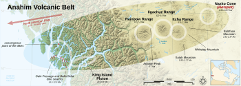
The Itcha Range is part of a chain of volcanoes called the Anahim Volcanic Belt. This chain stretches from west to east. The volcanoes get younger as you move eastward. Scientists believe this chain formed because of a "hotspot" under the Earth's surface. A hotspot is a very hot spot in the mantle that melts rock. As the North American Plate slowly moves westward, it passes over this stationary hotspot. This creates new volcanoes in a line. The Nazko Cone, a volcano east of the Itcha Range, is currently over this hotspot.
Volcanic activity in this belt started about 10 to 14 million years ago. The Rainbow Range volcano formed about 8.7 to 6.7 million years ago. Then, the Ilgachuz Range volcano formed about 6.1 million years ago. The Itcha Range is the youngest of these three large shield volcanoes. It started forming about 3.5 million years ago and continued to be active into recent times.
What is the Itcha Range made of?
The Itcha Range is the smallest shield volcano in the Anahim Volcanic Belt. It is made of many smaller volcanic parts joined together. It looks similar to small volcanoes found in Africa. About 60% of the volcano is visible, while 40% is covered by glacial deposits. This shows that glaciers covered the Itcha Range many times in the past. Evidence suggests that glaciers and volcanic eruptions happened at the same time.
At 2,375 meters (7,792 ft), the Itcha Range is the lowest of the three Anahim shield volcanoes. Its highest point is Mount Downton, in the middle of the range. Itcha Mountain is the second highest, at 2,290 meters (7,513 ft). These peaks sit on top of the main volcano.
The Itcha Range has a wide, gently sloping shape, which is typical for shield volcanoes. It is mostly made of thick lava flows, about 70 to 150 meters (230 to 490 ft) thick. These flows came from a central opening. On top of these are thinner lava flows, 1 to 4 meters (3 to 13 ft) thick, and at least 30 small cinder cones. The most common rock type is hawaiite, but other types like basalt are also found.
Underneath the Itcha Range, there are older rocks from the late Mesozoic era. These rocks formed long before the Itcha Range volcano began to grow.
How the volcano grew
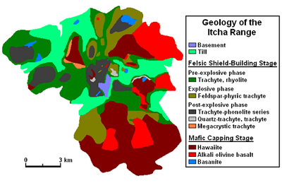
The Itcha Range volcano grew in two main stages. The first stage, called the "felsic shield-building stage," happened between 3.8 and 3.0 million years ago. During this time, the volcano erupted different types of lava. At first, the lava was very fluid and spread out far. Later, the lava became thicker and stickier. This meant that less lava came out with each eruption. This stage built the main body of the shield volcano.
After this first stage, the volcano was quiet for about 900,000 years. During this time, erosion wore down its gentle slopes. Then, a second stage, called the "mafic capping stage," began between 2.2 and 0.8 million years ago. During this stage, different types of basalt lava erupted. These lavas came from smaller vents and covered parts of the older shield. The lava flows became thicker and smaller in volume over time. This suggests that the heat source under the volcano was getting weaker. Some scientists think there might have been even more recent activity, perhaps as recently as 340,000 years ago.
The main part of the volcano covers about 300 square kilometers (116 sq mi). Volcanic activity also spread south to the Satah Mountain area, covering another 250 square kilometers (97 sq mi). Even though the Satah Mountain volcanic field is separate, it is connected to the Itcha Range by a ridge of volcanoes.
Early growth of the volcano
The first stage of growth started with eruptions of different types of lava like phonolite and rhyolite. These eruptions mostly happened at the top of the volcano. A rocky ridge connecting Mount Downton and Itcha Mountain might have been where these eruptions came from.
Later, explosive eruptions happened. These eruptions produced ash, pumice, and small lava flows. These materials spread out from the summit towards the northeast and east. Because these deposits are now buried, we don't know their full thickness.
The first stage ended with more lava flows and small volcanic plugs. These eruptions happened mainly at the summit and on the western side of the volcano. Mount Downton and Itcha Mountain were formed during this time. The last eruptions of this stage produced thick lava flows on the western side.
Later activity of the volcano
During the second stage, lava flowed from small parasitic cones and cracks in the eastern part of the volcano. These eruptions happened both under glaciers, under water, and on land. Each small cone usually produced three or four lava flows. These flows were either smooth (pāhoehoe) or rough (ʻaʻā).
This stage began with smooth hawaiite lava flows. These came from cracks and old cinder cones in the central and southeastern parts of the Itcha Range. At the same time, basalt lavas erupted from younger, well-preserved cinder cones. These basalt flows could be up to 30 meters (98 ft) thick.
The youngest known lavas are basanite flows in the northwestern and northeastern parts of the volcano. However, one cinder cone in the middle of the range might be even younger. It could be as young as the basanites at Nazko Cone, which erupted between 340,000 and 7,100 years ago.
Smaller volcanoes (Parasitic cones)
The smaller volcanoes, or parasitic cones, on the Itcha Range formed mostly between 2.2 and 0.8 million years ago. These are "monogenetic" volcanoes, meaning each cone erupted only once before becoming inactive. An eruption from one of these cones could last from hours to years. These small cinder cones are found on the top and sides of the main shield volcano.
| Name | Coordinates | References |
|---|---|---|
| Downton Cone 01 | 52°41′N 124°47′W / 52.69°N 124.79°W | Natural Resources Canada |
| Downton Cone 02 | 52°41′N 124°46′W / 52.68°N 124.77°W | Natural Resources Canada |
| Downton Cone 03 | 52°40′N 124°47′W / 52.67°N 124.78°W | Natural Resources Canada |
| Downton Cone 04 | 52°41′N 124°44′W / 52.68°N 124.73°W | Natural Resources Canada |
| Downton Cone 05 | 52°42′N 124°43′W / 52.70°N 124.72°W | Natural Resources Canada |
| Downton Cone 06 | 52°39′N 124°46′W / 52.65°N 124.77°W | Natural Resources Canada |
| Downton Cone 07 | 52°38′N 124°47′W / 52.64°N 124.79°W | Natural Resources Canada |
| Downton Cone 08 | 52°38′N 124°41′W / 52.64°N 124.69°W | Natural Resources Canada |
| Downton Cone 09 | 52°38′N 124°42′W / 52.64°N 124.7°W | Natural Resources Canada |
| Downton Cone 10 | 52°38′N 124°39′W / 52.64°N 124.65°W | Natural Resources Canada |
| Downton South-A | 52°37′N 124°53′W / 52.61°N 124.89°W | Natural Resources Canada |
| Downton South-B | 52°36′N 124°48′W / 52.60°N 124.8°W | Natural Resources Canada |
| Downton South-C | 52°37′N 124°46′W / 52.62°N 124.77°W | Natural Resources Canada |
| Downton South-D | 52°38′N 124°50′W / 52.63°N 124.83°W | Natural Resources Canada |
| Downton South-E | 52°37′N 124°43′W / 52.61°N 124.71°W | Natural Resources Canada |
| Itcha Cone 01 | 52°44′N 124°48′W / 52.73°N 124.8°W | Natural Resources Canada |
| Itcha Cone 02 | 52°44′N 124°46′W / 52.73°N 124.77°W | Natural Resources Canada |
| Itcha Cone 03 | 52°43′N 124°45′W / 52.72°N 124.75°W | Natural Resources Canada |
| Itcha Cone 04 | 52°46′N 124°48′W / 52.76°N 124.8°W | Natural Resources Canada |
| Itcha Cone 05 | 52°46′N 124°49′W / 52.76°N 124.81°W | Natural Resources Canada |
| Itcha Cone 06 | 52°46′N 124°51′W / 52.76°N 124.85°W | Natural Resources Canada |
| Itcha Cone 07 | 52°45′N 124°53′W / 52.75°N 124.89°W | Natural Resources Canada |
| Itcha Cone 08 | 52°43′N 124°55′W / 52.72°N 124.91°W | Natural Resources Canada |
Human History of the Itcha Range
How the mountains got their names
The Itcha Range has had a few names. It was first called the Itcha Mountains in 1930. Then, in 1947, its name was officially changed to Itcha Range. This was part of a government plan to rename smaller mountain groups. People sometimes still call it the Itchas in everyday talk. The name Itcha comes from the local Tsilhqot'in Indigenous people.
Mount Downton was named by D. M. MacKay, a land surveyor. He named it after Geoffrey M. Downton, another surveyor. Geoffrey Downton was known for finding out how much power could be made from the water between the Bridge River and Seton Lake. This name became official in 1947. The name Itcha Mountain was given to the second highest peak in 1954.
People of the Itcha Range
Indigenous people from the Dakelh and Tsilhqot'in tribes have lived in this area for hundreds of years. Before Europeans arrived, these people lived a nomadic lifestyle. This means they moved around to find food and resources. They hunted animals like moose and caribou. In summer, they gathered roots, plants, and a special volcanic glass called obsidian.
Obsidian from Anahim was traded widely. It was used to make very sharp arrowheads and knives. Some Indigenous people still practice parts of this traditional lifestyle today.
Settlers came to the area from Bella Coola in the early 1900s. They started ranches. One ranch, the Home Ranch, used the Blackwater Trail to move supplies and cattle. You can still see remains of this ranch and old trails today.
In 1995, the Itcha Range and the land around it became a provincial park. This park is called Itcha Ilgachuz Provincial Park. It protects the grasslands, wetlands, and animal homes. The park covers a huge area of about 111,977 hectares (276,700 acres).
Volcano Monitoring and Safety
The Itcha Range, like other volcanoes in the Anahim Volcanic Belt, is not watched very closely by the Geological Survey of Canada. While there is a network of sensors to detect earthquakes in Canada, it's too far away to give a clear picture of what's happening under the Itcha Range. It might only detect activity if the volcano starts to become very restless or erupt.
If the Itcha Range were to erupt, there are plans in place to help people. The Interagency Volcanic Event Notification Plan (IVENP) helps different agencies work together. They would notify people if an eruption happened in Canada, near the Canada–United States border, or if it affected Canada.
Because the Itcha Range is in a remote area, future eruptions are not a big danger to many people. Any future eruptions would likely be small, like basaltic cinder cones. However, larger eruptions are still possible. The main dangers would be forest fires from lava flows and problems for airplanes if a large eruption column of ash is produced. Volcanic ash can make it hard to see and can damage jet engines.
 | Victor J. Glover |
 | Yvonne Cagle |
 | Jeanette Epps |
 | Bernard A. Harris Jr. |


