Seton Lake facts for kids
Quick facts for kids Seton Lake |
|
|---|---|

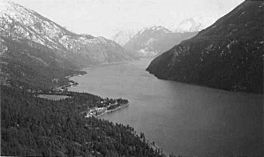
Seton Lake from Mission Mountain, c. 1950 Shalalth and Ohin on points at left. Looking west towards Mount Brew and Lillooet
|
|
 |
|
| Location | British Columbia |
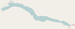
| Coordinates | 50°41′17″N 122°07′35″W / 50.68806°N 122.12639°W |
| Type | natural lake, reservoir |
| Primary outflows | Cayoosh Creek, Fraser River |
| Basin countries | Canada |
| Surface area | 26.2 km2 (10.1 sq mi) |
| Average depth | 460 m (1,500 ft) |
| Surface elevation | 243 m (797 ft) |
| Settlements | Lillooet, Seton Portage, Shalalth |
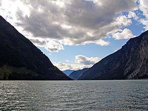
Seton Lake is a beautiful freshwater lake in British Columbia, Canada. It is shaped like a long, narrow valley filled with water, which is called a fjord. The lake drains east into the Fraser River at the town of Lillooet.
Seton Lake is about 22 kilometers (14 miles) long. It covers an area of 26.2 square kilometers (10.1 square miles). The lake is also very deep, reaching about 457 meters (1,500 feet) in some places. It sits at an elevation of 243 meters (797 feet) above sea level.
Contents
About Seton Lake
Seton Lake is a natural lake, meaning it formed on its own. However, its water level was raised a little bit. This happened as part of a big project called the Bridge River Power Project. This project uses water to create electricity.
How the Lake Changed
Before the power project, Seton Lake was known for its clear, bright blue water. But after the project started, water from the Bridge River was sent into Seton Lake. This water carried fine silt from glaciers. This silt changed the lake's color. Now, Seton Lake looks more like a dull turquoise. Its nearby neighbor, Anderson Lake, is now considered the bluer of the two lakes.
Where the Water Comes From
The main source of water for Seton Lake is the Seton Portage River. This short river connects Seton Lake to Anderson Lake. Anderson Lake gets its water from several creeks. These include Whitecap Creek and Spider Creek. Whitecap Creek starts high up on Whitecap Mountain. Spider Creek comes from an unnamed mountain peak to the south of Seton Lake.
Traveling by the Lake
The Canadian National Railway runs along the north shore of Seton Lake. This railway was once known as the British Columbia Railway. Before that, it was called the Pacific Great Eastern.
How Seton Lake Got its Name
The lake was named in the 1860s by Alexander Caulfield Anderson. He explored this area in 1846. He named the lake after his cousin and childhood friend, Lt. Col. Alexander Seton. Sadly, Alexander Seton drowned in 1852 when his ship, the HMS Birkenhead, sank off the coast of South Africa.
In 1858, a travel route called the Douglas Road was created. This route used the lake as part of its journey.
 | Isaac Myers |
 | D. Hamilton Jackson |
 | A. Philip Randolph |


