Anderson Lake (British Columbia) facts for kids
Quick facts for kids Anderson Lake |
|
|---|---|
 |
|
| Location | Lillooet Country, British Columbia |
| Coordinates | 50°38′N 122°23′W / 50.633°N 122.383°W |
| Primary inflows | Gates River |
| Primary outflows | Seton River |
| Basin countries | Canada |
| Max. length | 21 km (13 mi) |
| Surface area | 28.5 km2 (11.0 sq mi) |
| Max. depth | 215 m (705 ft) |
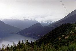
Anderson Lake is a large, deep lake located in the beautiful British Columbia province of Canada. It's found about 25 miles north of the town of Pemberton. The lake is about 21 kilometers (13 miles) long and covers an area of 28.5 square kilometers (11 square miles). At its deepest point, Anderson Lake reaches an impressive 215 meters (705 feet) down!
The lake is fed by the Gates River, which flows from the Pemberton Pass area. Water then flows out of Anderson Lake into the Seton River. This river eventually connects to Seton Lake and then the mighty Fraser River.
Contents
How Anderson Lake Was Formed
Anderson Lake and Seton Lake were once part of the same giant lake. But between 10,000 and 20,000 years ago, a huge landslide happened. This massive slide came from the north side of the Cayoosh Range, which is a mountain range next to Anderson Lake. The landslide created a natural barrier, splitting the original lake into the two lakes we know today: Anderson Lake and Seton Lake.
The area where the landslide happened is now known as Seton Portage. This place became very important during the Fraser Canyon Gold Rush of 1858–59. Gold seekers used a route called the Douglas Road, and a steamer boat named Lady of The Lake helped them travel across the water.
Communities Around the Lake
There are a few communities located around Anderson Lake.
- D'Arcy: At the northern end of the lake, near where the Gates River flows in, is the community of D'Arcy. The local St'at'imcets name for this place is N'quatqua.
- McGillivray Falls: Also on the lake is a community called McGillivray Falls. During World War II, this place served as a temporary home for Japanese Canadians who were forced to move from the British Columbia Coast.
Surrounding Area and Transportation
Looking north from Anderson Lake, you can see the Bendor Range mountains. Along the base of these mountains runs the British Columbia Railway. This railway was originally called the Pacific Great Eastern and is now owned by Canadian National Railways.
High above the lake, skirting the side of the Bendor Range, is a road known as the High Line Road. This road connects D'Arcy to Seton Portage. From near D'Arcy, there's also a trail that goes over the high McGillivray Pass. This trail leads to historic gold mining towns like Bralorne and Pioneer in the upper Bridge River Country.
See also
 In Spanish: Lago Anderson para niños
 | Isaac Myers |
 | D. Hamilton Jackson |
 | A. Philip Randolph |


