Douglas Road facts for kids
The Douglas Road was a major travel route used during the gold rush in British Columbia. It was also called the Lillooet Trail, Harrison Trail, or Lakes Route. This path connected the British Columbia Coast to the Interior of the province. More than 30,000 people are thought to have used this route. However, by the late 1860s, it was hardly used anymore. This was because the Cariboo Wagon Road was built, which went around this area.
Contents
History of the Douglas Road
Early Explorers and Gold Seekers
The Douglas Road was first explored by people from the Hudson's Bay Company in 1828. An explorer named Alexander Caulfield Anderson mapped it in 1846. Later, many gold seekers used this route. They wanted to avoid the dangerous Fraser Canyon to reach the gold-rich areas along the Fraser River near what is now Lillooet.
After a conflict in the Fraser Canyon in 1859, miners were worried about traveling through the land of the Nlaka'pamux people. Even though the conflict was over, people wanted a safer way to get to the upper Fraser River.
Building the Road for Safety
Thousands of people had already traveled this route. They faced terrible conditions, including heavy rain and lots of mosquitos. To help these travelers, Governor Sir James Douglas decided to build a proper wagon road. This road would cover the land parts of the route. He wanted to prevent people from starving, as many were already on the upper Fraser River.
This was one of the first big projects for the new Colony of British Columbia. Governor Douglas came up with a unique plan. Men who wanted to work on the road would pay $25 each. This money would be paid back to them in goods once they reached Lillooet.
Workers and Challenges
In 1858, 500 men signed up for the job. They were divided into two teams of 250. These workers came from many different places. There were people from Britain, the U.S., China, Mexico, Scandinavian countries, Hawaiians, Germans, and others.
After the road was built, there was a disagreement about how the workers would be paid back. The promise was to pay them back based on prices in Lillooet. However, prices were cheaper at Port Douglas, where the trail started. Governor Douglas decided to use the cheaper Port Douglas prices for the repayment.
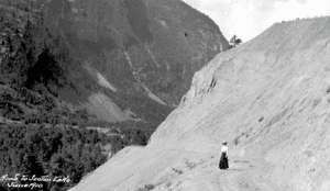
The road was not built very well at first. A year later, the Royal Engineers checked the route again and found it was hard to use. More money was spent to fix and improve it. They added bridges and made steep hills less difficult to climb.
The Road's Decline
Despite these improvements, the Douglas Road was not used much after 1861. This was mainly because the Cariboo Wagon Road was built. The Cariboo Road offered a more direct path to the goldfields.
However, the Douglas Road continued to be used by local people and a few travelers for many years. Regular steamer service to and from Port Douglas stopped in the 1890s. But smaller steamers kept running on Anderson and Seton Lake for decades. Service on Seton Lake finally ended in the 1950s.
Route of the Douglas Road
Starting Point and Water Travel
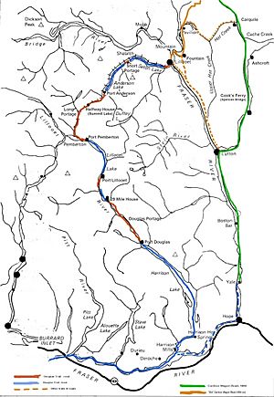
The Douglas Road began at Port Douglas, British Columbia. This town was at the top of Harrison Lake, which was as far as riverboats could go from the Strait of Georgia. From Port Douglas, a land trail followed the lower Lillooet River. This led to Port Lillooet, at the south end of Lillooet Lake.
From Port Lillooet, travelers used steamers and canoes to cross the lake. They would arrive at Port Pemberton, which was near the mouth of the Birkenhead River and close to today's Mount Currie.
Land Portages and More Lakes
The next land part of the route was called the Long Portage or the Pemberton Portage. A "portage" is a place where you carry boats or goods over land between two bodies of water. This section followed the lower Birkenhead River. Then, it turned away from the river to reach Birken Lake (also called Summit Lake or Gates Lake). From there, the route followed the Gates River to D'Arcy. This spot was at the head of Anderson Lake, and it was known as Port Anderson.
On Anderson Lake, different kinds of boats were used, including a small steamer called the "Lady of The Lake" and many native canoes. These boats carried travelers to the Short Portage, which is known today as Seton Portage.
Final Stretch to Lillooet
At Seton Portage, workers and later a short mule-drawn "railway" moved people and goods to the head of Seton Lake. From there, more steamers carried them to the end of that lake. The final part was a five-mile wagon road that led to the busy gold rush towns of Cayoosh Flat, Parsonville, and Marysville. Today, this area is known as Lillooet.
Lillooet became "Mile 0" for a new toll road that was built in response to the Cariboo Gold Rush. This road went from Lillooet to Fort Alexandria. It followed the Fraser Canyon for about 20 miles. Then, it turned east onto the Cariboo Plateau through the town of Clinton. This is where the later Cariboo Wagon Road connected with the older Douglas Road route.
 | Chris Smalls |
 | Fred Hampton |
 | Ralph Abernathy |


