Lillooet Lake facts for kids
Quick facts for kids Lillooet Lake |
|
|---|---|

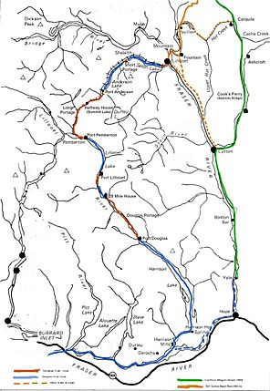
Lillooet Lake's position on the route of the Douglas Road (water portions in blue, land portions in red) and the Cariboo Road (green)
|
|
| Location | British Columbia |
| Coordinates | 50°15′N 122°30′W / 50.250°N 122.500°W |
| Basin countries | Canada |
| Max. length | 25 km (16 mi) |
| Surface area | 33.5 km2 (12.9 sq mi) |
Lillooet Lake is a beautiful lake located in British Columbia, Canada. It's about 25 kilometers (15.5 miles) long and covers an area of roughly 33.5 square kilometers (13 square miles). The lake is an important part of the Lillooet River system. The Lillooet River flows into the lake and then continues its journey after leaving it.
Near Lillooet Lake, you'll find other rivers joining the system. The Birkenhead River flows into the Lillooet River right where it enters the lake. A bit further upstream, the Green River, which starts at Green Lake near the popular resort town of Whistler, also joins the Lillooet River.
Contents
Where is Lillooet Lake Located?
Lillooet Lake is surrounded by interesting places and stunning nature.
Nearby Communities
- The town of Pemberton is about 12 kilometers (7.5 miles) upstream from the start of Lillooet Lake.
- The eastern edge of the Mount Currie Indian Reserve touches the lake's shore. This reserve is home to the Lil'wat people, who are part of the larger St'at'imc First Nation.
Surrounding Mountains and Parks
- To the west, the tall mountains of Garibaldi Provincial Park look down over Lillooet Lake. This park is known for its amazing scenery and outdoor activities.
- To the east, you'll see the northern parts of the Lillooet Ranges. These mountain ranges are located between the Lillooet-Harrison river system and the mighty Fraser River.
Lillooet Lake's Role in History
Lillooet Lake played a very important role in British Columbia's history, especially during the exciting time of the gold rush.
The Douglas Road
Lillooet Lake was once a key part of a famous travel route known as the "Lakes Route" or the Douglas Road. For a short time, this was the main way to travel between the coast of British Columbia and the interior regions. This was especially true during the Fraser Canyon Gold Rush, when many people were rushing to find gold.
Busy Waterway
During the gold rush days, Lillooet Lake was a very busy place! Many different kinds of boats used the lake to carry both goods and passengers.
- There were several large steamships, which were boats powered by steam engines.
- Countless smaller boats also used the lake.
One of the most famous and largest steamships was called the SS Prince of Wales. For many years, you could even see parts of its wreckage on the shores of the lake near Mount Currie. This shows just how important the lake was for transportation back then.
 | Aurelia Browder |
 | Nannie Helen Burroughs |
 | Michelle Alexander |


