
Garibaldi Provincial Park facts for kids
Quick facts for kids Garibaldi Provincial Park |
|
|---|---|
|
IUCN Category II (National Park)
|
|

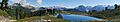
Garibaldi Lake and the Battleship Islands
|
|
_location_map.svg)
Garibaldi Provincial Park
Location in British Columbia
|
|
| Location | British Columbia, Canada |
| Nearest city | Squamish & Whistler, British Columbia |
| Area | 1,950 km2 (750 sq mi) |
| Established | April 29, 1920 |
| Governing body | BC Parks |
Garibaldi Provincial Park, often called Garibaldi Park, is a wild and beautiful park in British Columbia, Canada. It's about 70 kilometers (43.5 miles) north of Vancouver. The park was created in 1920 and became a special 'Class A' Provincial Park in 1927. Many people love to visit Garibaldi Park for outdoor fun. In 2017/2018, over 30,000 people camped overnight, and more than 106,000 visited for the day.
Garibaldi Park covers a huge area of over 1,950 square kilometers (753 sq mi). It includes most of the Garibaldi Range mountains. The western part of the park is easy to reach from the Sea-to-Sky Highway. This highway leads to popular spots like Elfin Lakes, Garibaldi Lake, The Black Tusk, Cheakamus Lake, and Wedgemount Lake. The eastern part of the park is much harder to get to. This makes it a very remote and wild area. To the south, Garibaldi Park connects with Golden Ears Provincial Park and Pinecone Burke Provincial Park. Its northern areas stretch past Whistler and end near Pemberton.
Park History
First Peoples of the Land
Before Europeans arrived, the Squamish people called Mount Garibaldi Nch'kay. This means "Dirty Place" or "Grimy One." They named it for the muddy water of the Cheekye River. The mountain was very important to the Squamish culture. They used the area around it for hunting, gathering food, and collecting obsidian (a type of volcanic glass). In Squamish stories, Nch'kay was the peak where people tied their canoes. This saved them from being swept away by the Great Flood.
.jpg)
Another important peak in the park is The Black Tusk. The Squamish people called it t'ak't'ak mu'yin tl'a in7in'a'xe7en. This name means "Landing Place of the Thunderbird." They believed the peak got its shape from the talons of the in7in'a'xe7en, or Thunderbird. The Lil'wat people called the same peak Q'elqámtensa ti Skenknápa. This means "Place Where the Thunder Rests."
How the Park Was Formed
Garibaldi Provincial Park got its modern name from Mount Garibaldi. Captain George Henry Richards named the mountain after Giuseppe Garibaldi in 1860. This happened during a survey of Howe Sound.

In 1907, a group of climbers from Vancouver reached the top of Mount Garibaldi for the first time. The amazing views from the peaks inspired them. They started summer climbing camps at Garibaldi Lake. Many members of the new British Columbia Mountaineering Club joined these camps. The first camp led to the naming and first climb of The Black Tusk in 1912. This interest helped the park become a protected area in 1920. It was then officially named a Class A Provincial Park in 1927.
In 1967, a part of Garibaldi Provincial Park was separated. It became Golden Ears Provincial Park.
Park Geology
Mountains, Glaciers, and Lakes
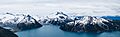
The park's landscape has many steep mountains, coastal forests, and high-altitude lakes. This scenery was shaped by ancient ice ages and volcanoes. For example, Mount Garibaldi erupted about 13,000 years ago.
.jpg)
There are over 150 glaciers in the park. These include the Garibaldi Névé and Mamquam icefields. The highest point in Garibaldi Park is Wedge Mountain. It stands at 2,891 meters (9,485 feet) tall. The park also has cool volcanic features. These include a flat-topped volcano called The Table. There's also a cone-shaped volcano called the Opal Cone. The park is home to the large volcanoes Mount Garibaldi and The Black Tusk. These are part of the Garibaldi Volcanic Belt.
Many beautiful lakes are found in the park. These include Garibaldi Lake, Cheakamus Lake, Mamquam Lake, and Elfin Lakes. The Pitt River, which flows into the Fraser River, also starts in the park.
The Barrier and Safety
Garibaldi Lake is held back by a natural wall of hardened lava called The Barrier. Around 1855–56, a part of this wall broke away. This caused a huge landslide of 25 million cubic meters of rock. It damaged the area below. In the 1970s, people realized The Barrier was not stable. Because of this, the area below it was declared unsafe in 1981. The nearby village of Garibaldi had to be moved for safety.

Today, the land right below The Barrier is called the Barrier Civil Defence Zone by BC Parks. Signs warn hikers not to camp, stop, or stay long in this hazard zone. This is to keep everyone safe.
Glaciers Shrinking
In 2007, scientists studied the glaciers in Garibaldi Park. They found that by 2005, the glaciers had shrunk a lot. They were only 49% of their size in the early 1700s. The study said this shrinking was due to global temperature changes in the 20th century.
Another study in 2013 confirmed these findings. It showed that the park's glaciers, like others in western Canada, are the smallest they have been in thousands of years.
Park Ecology
Plants of Garibaldi Park
The types of plants in Garibaldi Park change with how high up you go. Lower down, between 1,000 and 1,700 meters (3,280 and 5,577 feet), you'll find thick forests. These forests have Douglas-fir, western red cedar, and western-hemlock trees. Higher up, you'll see forests of mountain hemlock, yellow cedar, alpine fir, and white bark pine. These forests eventually turn into open areas with small, twisted trees.

Much of the park is in high-altitude areas. The park's alpine meadows are covered with many kinds of alpine plants. These include heather, western anemone, lupine, arnica, Indian paintbrush, and avalanche lily. The park's flowers are usually at their brightest in August.
Animals of Garibaldi Park
Many animals live in Garibaldi Park. You might see grizzly and black bears. There are also mountain goats, deer, marmots, and pikas. Many birds also call the park home. These include golden eagles, bald eagles, blue jays, whiskey jacks, and ptarmigans.
In 1990, the park checked on its mountain goat population. They found about 50 to 70 goats in the Spearhead area. The goal was to keep these goat populations healthy. This would stop them from becoming endangered. Later checks in 2012 and 2013 showed the goats were still doing well in that area.
Fun Activities in the Park
Garibaldi Provincial Park is a great place for outdoor adventures. It has many kilometers of hiking trails and campgrounds. You can also camp in winter. In 2016, the park became so popular that you now need to book your overnight stays online in advance. This helps manage the large number of visitors.
The most popular activities are hiking and backcountry camping. But you can also enjoy fishing, swimming, canoeing/kayaking, rock climbing, mountaineering, mountain biking, and backcountry skiing. Most of the ways to enter the park and its facilities are on the west side. The eastern part is wilder and less visited.

How to Get Into the Park
The park has five main entry points. All of them are off the Sea-to-Sky Highway. Each entry point leads to a different part of the park. However, you can reach many areas by following the park's connected trails.
- Diamond Head is the entry point furthest south. It offers hiking and skiing access to areas like Mamquam Lake, Red Heather Meadows, and Elfin Lakes.
- The Black Tusk/Garibaldi Lake entrance is between Squamish and Whistler. From here, a steep trail leads to Garibaldi Lake. You can also reach the Garibaldi Lake and Taylor Meadows campgrounds. This entrance also takes you to The Black Tusk and Panorama Ridge. It connects to Cheakamus Lake by a trail to the north.
- Cheakamus Lake is an entrance just south of Whistler. It provides access to Cheakamus Lake and connects to other trails.
- Singing Pass is reached from Whistler. This path follows Fitzsimmons Creek between Whistler and Blackcomb mountains. An alpine route also connects to Singing Pass from the top of Whistler.
- Wedgemount Lake is the entry point furthest north. You reach it by a forest service road. This road leads to Wedgemount Lake.

Camping in the Park
Garibaldi Park offers both walk-in camping and wilderness camping. There are also some shelters. You must reserve all walk-in campgrounds before you go. Wilderness camping is allowed only in the Garibaldi Wilderness Camping Area. This area is away from the busier spots and has special rules. There are 11 walk-in campgrounds in the park. One, Red Heather Meadows, is only open in winter. Campgrounds range from 6 sites at Singing Creek to 50 sites at Garibaldi Lake.
There are four shelters for overnight use:
- Elfin Lakes Shelter is at Elfin Lakes and can be reserved all year. It fits 33 people and has propane stoves provided by BC Parks.
- Russet Lake Hut was built in 1968. It's a small cabin used for cooking and storing food safely from bears. It sleeps 6 people. There are plans to replace it.
- Wedgemount Lake Hut was built in 1970. It's a basic hut mainly for emergencies.
- Burton Hut, also called the Sphinx Hut, is near the Garibaldi Lake campground. It can fit 10–15 people. Students from the University of British Columbia built it in 1969.
Hiking Trails

The park has over 90 kilometers (56 miles) of trails. You can use them all year. In winter, you will need snowshoes or skis. Some popular trails include:
- Garibaldi Lake Trail: This trail takes hikers to Garibaldi Lake and its campground.
- Panorama Ridge Trail: This trail ends at an amazing viewpoint overlooking Garibaldi Lake.
- The Black Tusk Trail: This trail starts at Garibaldi and Cheakamus Lake. It reaches the base of The Black Tusk. A difficult climb can take you to the very top.
- Elfin Lakes Trail: This trail leads to the lakes and is most popular in summer. It also gives access to the Opal Cone and Mamquam Lake.
- Wedgemount Lake Trail: This is a steep hike leading to Wedgemount Lake.
Other Fun Activities
- Winter sports are popular when it snows. You can ski tour most of the park. The Diamond Head area is especially popular in winter.
- Fishing is allowed with a permit at Garibaldi, Cheakamus, and Mamquam lakes.
- Canoeing and kayaking are allowed only at Cheakamus Lake.
- Swimming is permitted at Elfin Lakes (in special areas), Garibaldi, Cheakamus, Russet, and Wedgemount lakes. There are no lifeguards. The lakes are very cold because they are fed by glaciers.
- Rock climbing is possible on granite walls around the park. You can find spots in local climbing guidebooks. Climbing The Black Tusk is not usually recommended because of loose rocks.
- Cycling is not allowed in most of the park. However, it is permitted on parts of the Elfin Lakes trail and Cheakamus Lake trail.
- Mountaineering is one of the oldest sports in the park. It started with the first climb of Mount Garibaldi. Many peaks offer great opportunities for climbing.
Images for kids
-
Panorama of the Elfin Lakes
-
Panorama of Garibaldi Lake from Panorama Ridge
