Garibaldi Ranges facts for kids
Quick facts for kids Garibaldi Ranges |
|
|---|---|

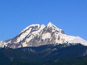
Mount Garibaldi as seen from Squamish, British Columbia
|
|
| Highest point | |
| Peak | Wedge Mountain |
| Elevation | 2,892 m (9,488 ft) |
| Dimensions | |
| Area | 4,337 km2 (1,675 sq mi) |
| Geography | |
| Country | Canada |
| Settlement | Squamish |
| Parent range | Pacific Ranges |
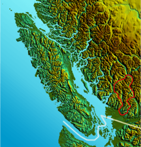
The Garibaldi Ranges are a group of mountains in British Columbia, Canada. They are part of the larger Coast Mountains range. These mountains are located between the Resort Municipality of Whistler to the west and the Lillooet River valley to the east.
The Garibaldi Ranges stretch south towards Maple Ridge and Mission, which are towns near Vancouver. To their south are the North Shore Mountains. The ranges get their name from Mount Garibaldi, a famous mountain on their western side. This mountain also gives its name to Garibaldi Provincial Park.
The southern part of the Garibaldi Ranges includes Golden Ears Provincial Park. This park was once part of Garibaldi Park.
Contents
Famous Peaks and Features
One of the most well-known mountains in the Garibaldi Ranges is The Black Tusk. It's not the tallest, but it's very unique. The Black Tusk is a volcanic plug, which is like the hardened core of an ancient volcano. It stands out between Garibaldi and Cheakamus Lakes, near Whistler.
The highest peak in the Garibaldi Ranges is Wedge Mountain. It's located just north of Whistler and stands at 2,892 meters (9,488 feet) tall. People sometimes call it "The Wedge."
Northern Garibaldi Ranges
The northern part of the Garibaldi Ranges is mostly covered by Garibaldi Provincial Park. This area is very alpine, meaning it has features like the Alps. You can find large icefields and many high, jagged peaks here.
Southern Garibaldi Ranges
The southern part of the range is north of Stave Lake. It's also between the upper Pitt River and the lower Lillooet River. This area doesn't have big icefields. Instead, it has many deep, U-shaped valleys. Some of these valleys are more than 1,500 meters (5,000 feet) deep.
The peaks in the southern part have very steep sides, some rising almost vertically for over 2,100 meters (7,000 feet). The highest peak in this area is Mount Judge Howay, which is 2,262 meters (7,421 feet) tall.
The southernmost major peaks are in Golden Ears Provincial Park. These peaks look a bit like a donkey's ears. They were named "Golden Ears" because they glowed in the sunset when they were first seen. The highest of these is Golden Ears at 1,716 meters (5,630 feet).
Sub-ranges
The Garibaldi Ranges are made up of several smaller mountain groups, called sub-ranges. These include:
- Garibaldi Névé
- Fitzsimmons Range
- Musical Bumps
- McBride Range
- Spearhead Range
- Golden Ears
- Misty Icefield
- Bastion Range
See also
 In Spanish: Cordillera Garibaldi para niños
 | John T. Biggers |
 | Thomas Blackshear |
 | Mark Bradford |
 | Beverly Buchanan |


