
Pitt River facts for kids
Quick facts for kids Pitt River |
|
|---|---|

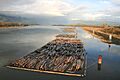
Pitt River, looking north from the Lougheed highway bridge in Port Coquitlam
|
|

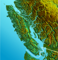
Location of Pitt River
|
|
| Country | Canada |
| Province | British Columbia |
| Physical characteristics | |
| Main source | Garibaldi Ranges Coast Mountains |
| River mouth | Fraser River Pitt Meadows, Port Coquitlam, Greater Vancouver Regional District 5 m (16 ft) 49°13′43″N 122°46′4″W / 49.22861°N 122.76778°W |
| Basin features | |
| Tributaries |
|
The Pitt River is a large river in British Columbia, Canada. It flows into the Fraser River a few miles upstream from New Westminster. This is about 25 kilometers (15 miles) southeast of Downtown Vancouver.
The river starts in the Garibaldi Ranges of the Coast Mountains. It flows mostly south. The Pitt River has two main parts: one above Pitt Lake and one below it. Pitt Lake and the lower Pitt River are affected by the ocean's tides. This is because the Fraser River's mouth, where it meets the ocean, is very close by.
Contents
River's Name and History
The Pitt River was named after William Pitt the Younger. He was a famous British Prime Minister. The name "Pitts River" first appeared in a journal in 1827. This journal was kept by James McMillan of the Hudson's Bay Company.
The river also has another name, Quoitle. This name likely comes from the Kwantlen First Nation. They are an Indigenous group who have lived in this area for a very long time.
Where the River Flows
The lower part of the Pitt River is about 20 kilometers (12 miles) long. To the east of this section is the community of Pitt Meadows. To the west are the cities of Coquitlam and Port Coquitlam. Across from where the Pitt River joins the Fraser River is Surrey.
Port Coquitlam and Pitt Meadows are connected by bridges. These include the Highway 7 bridges. There are also train bridges for the CPR. The CPR has large train yards on the west side of the Pitt River.
Long ago, the flat land around the lower Pitt River was mostly marsh and bog. People built dikes to control the water. This allowed the land to be used for farming. Most of the farms are on the east side in Pitt Meadows. The soil on the west side was not as good. This led to more homes and neighborhoods being built in Port Coquitlam.
Minnekhada Regional Park
On the west side of the lower Pitt River, you can find Minnekhada Regional Park. This park was once the home of Clarence Wallace. He was a former lieutenant-governor of British Columbia. Over time, parts of the land were sold. Eventually, the Province of British Columbia bought it to protect it.
The Upper Pitt River
The upper part of the Pitt River is shorter. However, it gets a lot of water from different sources. These include ice fields, glaciers, and mountain streams. Some of these are the Garibaldi Névé and the Mamquam Icefield. Because of this, the river becomes quite large even only 50 kilometers (30 miles) from where it starts.
The upper river begins in Garibaldi Provincial Park. To the east of the upper Pitt River is Golden Ears Provincial Park. This park used to be part of Garibaldi Provincial Park.
You can often see barges on Pitt Lake. These barges carry logs from logging camps in the upper Pitt River area. They also travel near the highway and train bridges close to where the Pitt River meets the Fraser River.
River Connections
The Pitt River is one of several river valleys that flow from north to south. These valleys join the lower Fraser River from its north side. Other rivers in this group include:
- The Coquitlam River
- The Alouette River
- The Stave River
- Norrish Creek
- The Chehalis River
- The valley of Harrison Lake, which is about 60 kilometers (37 miles) east of the Pitt River.
See also

- In Spanish: Río Pitt para niños
Images for kids
-
Pitt River, looking north from the Lougheed highway bridge in Port Coquitlam
-
Location of Pitt River
