
Harrison Lake facts for kids
Quick facts for kids Harrison Lake |
|
|---|---|
 |
|

Harrison Lake
Location in British Columbia
|
|
| Location | Coast Mountains, British Columbia |
| Coordinates | 49°30′N 121°50′W / 49.500°N 121.833°W |
| Primary inflows | Lillooet River, Silver Creek |
| Primary outflows | Harrison River |
| Basin countries | Canada |
| Max. length | 60 km (37 mi) |
| Max. width | 9 km (5.6 mi) |
| Surface area | 218 km2 (84 sq mi) |
| Max. depth | 279 m (915 ft) |
| Water volume | 33 km3 (27,000,000 acre⋅ft) |
| Surface elevation | 10 m (33 ft) |
| Settlements | Harrison Hot Springs |
Harrison Lake is the biggest lake in the southern Coast Mountains of Canada. It covers about 250 square kilometers (95 square miles). The lake is about 60 kilometers (37 miles) long and nearly 9 kilometers (5.6 miles) wide.
Its southern end is home to Harrison Hot Springs, a popular resort town. This spot is about 95 kilometers (59 miles) east of downtown Vancouver, British Columbia. The Lillooet Ranges are to the east of the lake, and the Douglas Ranges are to the west. Harrison Lake is the last in a series of large valleys that flow into the Fraser River.
Contents
Exploring Harrison Lake
At the northern tip of Harrison Lake, you'll find a small First Nations community. This village, called Port Douglas, belongs to the In-SHUCK-ch Nation. Its name in the St'at'imcets language is Xa'xtsa (ha-htsa).
Hot Springs and Special Places
There are three natural hot springs located around Harrison Lake. One is near Port Douglas, another is at Clear Creek (a branch of the Silver River), and the most famous is at Harrison Hot Springs.
Doctors Point, on the lake's northwest side, was once a village. It's also a special "Transformer site." Here, you can see a large rock painting. It might show the spirit of the winds that control travel on the lake. Or, it could be a medicine man turned to stone by a powerful spirit called "the Transformer."
Rivers and Islands
The main river flowing into Harrison Lake is the Lillooet River. At the head of this river's bay, there was once a ghost town called Port Douglas. Today, the Port Douglas Band of the In-SHUCK-ch Nation has a village there.
Halfway down the eastern side of Harrison Lake is the valley of the Silver River. It's also known as the Big Silver River. On the opposite side of the lake, to the west, is Twenty-Mile Bay.
In the middle of the lake, between Silver River and Twenty-Mile Bay, lies Long Island. It's the lake's longest island, stretching 9.5 kilometers (5.9 miles) long and 2.6 kilometers (1.6 miles) wide. Another important island is Echo Island. It's 4 kilometers (2.5 miles) long and 2.2 kilometers (1.4 miles) wide. Echo Island is just off the shore of Harrison Hot Springs. The Harrison River flows out of the lake near this island and joins the Fraser River near Chehalis.
History of Harrison Lake
Harrison Lake played a big role in the early history of British Columbia. It was part of the Douglas Road, a water route used during the Fraser Canyon Gold Rush (1858-1860). This road helped miners reach the goldfields along the upper Fraser River.
The lake was named "Harrison" by Governor Simpson of the Hudson's Bay Company. He named it after Benjamin Harrison, who was a director of the company.
Images for kids
-
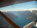
The back half of Harrison Lake, seen from the air.


See also
 In Spanish: Lago Harrison para niños
