
Pitt Meadows facts for kids
Quick facts for kids
Pitt Meadows
|
||
|---|---|---|
| City of Pitt Meadows | ||

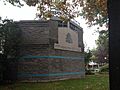
Pitt Meadows City Hall.
|
||
|
||
| Motto(s):
"Prosperity Through Endeavour"
|
||

Location of Pitt Meadows in Metro Vancouver
|
||
| Country | Canada | |
| Province | British Columbia | |
| Regional district | Metro Vancouver | |
| Incorporated as a district municipality | April 25, 1914 | |
| Incorporated as a city | January 1, 2007 | |
| Named for | Pitt River, Pitt Lake | |
| Government | ||
| • Type | Mayor-council government | |
| • Body | Pitt Meadows City Council | |
| Area | ||
| • Land | 86.34 km2 (33.34 sq mi) | |
| Elevation | 8 m (26 ft) | |
| Population
(2021)
|
||
| • Total | 19,146 | |
| • Estimate
(2024)
|
21,302 | |
| • Density | 221.7/km2 (574/sq mi) | |
| Time zone | UTC-8 (PST) | |
| • Summer (DST) | UTC-7 (PDT) | |
| Forward sortation area |
V3Y
|
|
| Area codes | 604, 778, 236, 672 | |

Pitt Meadows is a city in British Columbia, Canada. It's part of the Metro Vancouver Regional District. The city got its name from the Pitt River and Pitt Lake.
People have lived in Pitt Meadows for about 1,000 years. In 1874, the area was part of the Municipality of Maple Ridge. But in 1892, people in Pitt Meadows wanted their own community. The city was officially formed in 1914. Back then, it was a small farming town with fewer than 250 people. They grew food and raised dairy cows for nearby cities like Vancouver. In 2007, Pitt Meadows changed from a district to a city. In 2014, it celebrated its 100th birthday!
Contents
History of Pitt Meadows
Early Days and First Settlers
Long ago, about 1,000 years ago, Indigenous Peoples lived in the Pitt Meadows area. European settlers started arriving in the 1870s. They called their settlement Bonson's Landing. Most early settlers were from England until after 1910. The city, river, and lake are all named after William Pitt the Younger, a British prime minister.
In 1885, the Canadian Pacific Railway was built through Pitt Meadows. This connected the area to other towns. The Pitt Meadows General Store was built in 1886. It was the first post office and had the first telephone in the community. Today, it's the Pitt Meadows Museum and Archives.
In 1893, the first system of dikes was built to protect the land from floods. However, the Fraser River Flood of 1894 still covered many areas in Pitt Meadows.
Becoming a Municipality
Pitt Meadows became its own municipality in 1914. Before that, it was not officially organized. In 1914, it was a small farming community. After 1910, many French Canadians and Japanese families moved to the area.
After World War II
After World War II, many Dutch farmers came to Pitt Meadows. They helped reclaim much of the low-lying land. In 1948, a big flood happened again because of heavy snowmelt.
The second Pitt River Bridge opened in 1957, replacing an older bridge from 1915. Another bridge was added in 1978. The Pitt Meadows Regional Airport opened in 1963.
Heritage and Symbols

Pitt Meadows has a special Heritage Preservation Area. Here, you can find old buildings like the General Store, which is now the Pitt Meadows Museum. The Hoffmann and Sons Garage is also there. Hans Hoffmann, a mechanic, worked at and ran this family business for nearly 45 years.
In 1990, the Pitt Meadows Cenotaph was built. It honors those who served and died for the country. In 2012, British Columbia apologized for sending Japanese-Canadian families to special camps during World War II. Tosh Suzuki's family, from a berry farm in Pitt Meadows, was one of them.
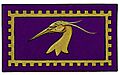
The city's official symbols were announced in 2005. The city's shield has purple and gold colors. It features a heron, a bird often seen in the area. The band on the shield shows the dikes that protect the land. The gear-like edges represent the historic Hoffmann garage. The horizontal lines stand for the Canadian Pacific Railway line. The city's motto is "Prosperity through endeavour." The crown on top represents the Golden Ears peaks to the north. White drops recall the early dairy farms. An eagle symbol from the Katzie First Nation honors the original Indigenous people.
- Pitt Meadows symbols
-
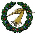
Heraldic badge of Pitt Meadows, BC
-
Pitt Meadows Townhall Crest
-
Herald of Pitt Meadows, BC
-

Former flag of Pitt Meadows


Centennial Celebration
In 2014, Pitt Meadows celebrated its 100th birthday! There were special parties and events for the community.
Geography and Environment
Pitt Meadows is in the Lower Fraser Valley, east of Vancouver. Most people live in the main town area. A large part of Pitt Meadows (82%) is in the "Green Zone." This includes important natural areas like forests, wetlands, and farms. These areas are vital for the environment of Metro Vancouver.
Pitt Meadows is a farming town. Over 68% of it is in a floodplain, which means it's low-lying land that can flood. About 86% of the land is protected farmland in the BC Agricultural Land Reserve. Important natural spots include Pitt-Addington Marsh and Codd Wetland Ecological Conservancy Area.

Pitt Meadows is located between the Fraser River to the south and Maple Ridge to the east. The Pitt River is to the west. Two parts of the Alouette River also flow through the city. To the north, Pitt Lake is the biggest freshwater tidal lake in the world. It connects to the Fraser River by the Pitt River. The Pitt River can even flow backward during high tide!
The city is protected from floods by 64 kilometers of dikes. These dikes also have trails for walking, cycling, and horseback riding. The northern part of the floodplain is a peat bog, which is a large wildlife refuge. Pitt Meadows is surrounded by growing communities like Coquitlam and Surrey.
Climate
Pitt Meadows has an oceanic climate. This means it has warm summers and cool, rainy winters.
| Climate data for Pitt Meadows CS WMO ID: 71775; 1991-2020 normals | |||||||||||||
|---|---|---|---|---|---|---|---|---|---|---|---|---|---|
| Month | Jan | Feb | Mar | Apr | May | Jun | Jul | Aug | Sep | Oct | Nov | Dec | Year |
| Record high °C (°F) | 15.5 (59.9) |
19.5 (67.1) |
23.8 (74.8) |
29.8 (85.6) |
36 (97) |
41.4 (106.5) |
37.6 (99.7) |
36.6 (97.9) |
35.5 (95.9) |
30 (86) |
20.0 (68.0) |
17 (63) |
41.4 (106.5) |
| Mean daily maximum °C (°F) | 6.8 (44.2) |
8.8 (47.8) |
11.3 (52.3) |
14.9 (58.8) |
19.0 (66.2) |
21.3 (70.3) |
25.0 (77.0) |
25.1 (77.2) |
21.5 (70.7) |
15.0 (59.0) |
9.6 (49.3) |
6.1 (43.0) |
15.4 (59.7) |
| Daily mean °C (°F) | 3.6 (38.5) |
4.6 (40.3) |
6.8 (44.2) |
9.7 (49.5) |
13.5 (56.3) |
16.1 (61.0) |
18.8 (65.8) |
18.8 (65.8) |
15.7 (60.3) |
10.5 (50.9) |
6.0 (42.8) |
3.1 (37.6) |
10.6 (51.1) |
| Mean daily minimum °C (°F) | 0.5 (32.9) |
0.4 (32.7) |
2.3 (36.1) |
4.5 (40.1) |
7.9 (46.2) |
10.8 (51.4) |
12.6 (54.7) |
12.4 (54.3) |
9.8 (49.6) |
5.9 (42.6) |
2.4 (36.3) |
0.1 (32.2) |
5.8 (42.4) |
| Record low °C (°F) | −19 (−2) |
−14 (7) |
−9.4 (15.1) |
−5 (23) |
−1 (30) |
0.6 (33.1) |
4.4 (39.9) |
5 (41) |
−1 (30) |
−5.5 (22.1) |
−19 (−2) |
−18 (0) |
−19 (−2) |
| Average precipitation mm (inches) | 252.4 (9.94) |
133.6 (5.26) |
173.4 (6.83) |
104.5 (4.11) |
95.3 (3.75) |
68.9 (2.71) |
47.6 (1.87) |
36.3 (1.43) |
94.0 (3.70) |
180.0 (7.09) |
249.0 (9.80) |
214.1 (8.43) |
1,649.1 (64.92) |
| Average precipitation days (≥ 0.2 mm) | 22.2 | 17.8 | 20.3 | 15.2 | 13.2 | 12.8 | 8.7 | 7.5 | 11.3 | 18.0 | 21.4 | 21.8 | 190.2 |
| Source: Environment Canada | |||||||||||||
People of Pitt Meadows
| Historical population | ||
|---|---|---|
| Year | Pop. | ±% |
| 1921 | 595 | — |
| 1931 | 832 | +39.8% |
| 1941 | 1,119 | +34.5% |
| 1951 | 1,434 | +28.2% |
| 1956 | 1,652 | +15.2% |
| 1961 | 2,187 | +32.4% |
| 1966 | 2,247 | +2.7% |
| 1971 | 2,771 | +23.3% |
| 1976 | 4,689 | +69.2% |
| 1981 | 6,209 | +32.4% |
| 1986 | 8,004 | +28.9% |
| 1991 | 11,147 | +39.3% |
| 1996 | 13,436 | +20.5% |
| 2001 | 14,670 | +9.2% |
| 2006 | 15,623 | +6.5% |
| 2011 | 17,736 | +13.5% |
| 2016 | 18,573 | +4.7% |
| 2021 | 19,146 | +3.1% |
In 2021, the population of Pitt Meadows was 19,146 people. This was a small increase from 2016. The city has a land area of 86.34 square kilometers.
Different Backgrounds in Pitt Meadows
Pitt Meadows is home to people from many different backgrounds. The table below shows the main groups living in the city over the years.
| Panethnic group |
2021 | 2016 | 2011 | 2006 | 2001 | |||||||||
|---|---|---|---|---|---|---|---|---|---|---|---|---|---|---|
| Pop. | % | Pop. | % | Pop. | % | Pop. | % | Pop. | % | |||||
| European | 13,670 | 71.85% | 14,375 | 78.02% | 13,860 | 78.26% | 12,865 | 82.39% | 12,770 | 87.14% | ||||
| East Asian | 1,250 | 6.57% | 960 | 5.21% | 675 | 3.81% | 930 | 5.96% | 390 | 2.66% | ||||
| Southeast Asian | 1,055 | 5.55% | 835 | 4.53% | 760 | 4.29% | 345 | 2.21% | 155 | 1.06% | ||||
| South Asian | 1,020 | 5.36% | 830 | 4.5% | 945 | 5.34% | 810 | 5.19% | 795 | 5.42% | ||||
| Indigenous | 780 | 4.1% | 565 | 3.07% | 805 | 4.55% | 385 | 2.47% | 310 | 2.12% | ||||
| Middle Eastern | 435 | 2.29% | 230 | 1.25% | 130 | 0.73% | 45 | 0.29% | 10 | 0.07% | ||||
| Latin American | 295 | 1.55% | 195 | 1.06% | 235 | 1.33% | 80 | 0.51% | 60 | 0.41% | ||||
| African | 165 | 0.87% | 205 | 1.11% | 190 | 1.07% | 65 | 0.42% | 115 | 0.78% | ||||
| Other/Multiracial | 360 | 1.89% | 115 | 0.62% | 100 | 0.56% | 85 | 0.54% | 55 | 0.38% | ||||
| Total responses | 19,025 | 99.37% | 18,425 | 99.2% | 17,710 | 99.85% | 15,615 | 99.95% | 14,655 | 99.9% | ||||
| Note: Totals greater than 100% due to multiple origin responses | ||||||||||||||
Religious Beliefs
In 2021, about 52.6% of people in Pitt Meadows said they had no religious beliefs. About 39.8% were Christian. Other religions practiced include Sikhism, Islam, Buddhism, Hinduism, and Judaism.
Getting Around Pitt Meadows
River Travel
.jpg)
Pitt Meadows is surrounded by the Pitt River and the Fraser River. These rivers were very important for early transportation and fishing. Today, the Fraser River is still used by boats for both work and fun. The Alouette River is important for farming areas.
Trains and Railways

The first land transportation was the Canadian Pacific Railway (CPR) in 1885. The main part of Pitt Meadows is crossed by the CPR line. The city's train station is called Pitt Meadows station.
Pitt Meadows Airport
The Pitt Meadows Regional Airport opened in 1963. It's used for smaller planes and has a skydiving school. There are rules about how tall buildings can be near the airport.
Bridges and Highways

Lougheed Highway is the main road through Pitt Meadows. The Pitt River Bridge connects Pitt Meadows to the Burrard Peninsula. A new, bigger Pitt River Bridge was finished in 2009.
The Golden Ears Bridge also opened in 2009. It connects Pitt Meadows and Maple Ridge to Surrey and Langley across the Fraser River.
Public Transportation

TransLink runs public transport in Pitt Meadows. The West Coast Express is a commuter train with stations at Maple Meadows and Pitt Meadows. Buses are operated by the Coast Mountain Bus Company. Route 701 is a major bus route that connects to Coquitlam. The R3 Rapid Bus also serves Lougheed Highway.
Easy Access for Everyone
The Pitt Meadows Paddling Club won an award for making activities easy for everyone. Their PaddleALL programs are for people with disabilities. Access Transit also provides special door-to-door transportation for people who need help using regular public transit.
Economy and Jobs

Most people in Pitt Meadows (about 85%) travel outside the city for work. Within Pitt Meadows, the biggest job areas are:
- Farming (20%)
- Education and Health (19%)
- Hotels, Restaurants, and Cafes (16%)
- Construction (9%)
Even with new businesses, 86% of Pitt Meadows' land is still used for farming. This land is part of the province's Agricultural Land Reserve. Farmers grow things like cranberries, blueberries, flowers, and special peppers. Some farms also offer "agritourism," where visitors can learn about farming. For example, the Meadows Maze is a large corn maze on Hopcott Farm.
Schools in Pitt Meadows
Pitt Meadows has one high school and four elementary schools. They are all part of School District 42 Maple Ridge-Pitt Meadows. Pitt Meadows Secondary School (PMSS) is known for its strong soccer and hockey programs. About 800 students attend PMSS.
Fun and Recreation

Pitt Meadows has many places for fun and community activities. There are parks, open spaces, trails, and bike paths. You can find a recreation center and ice skating rinks for indoor fun.
Outside, you can use the dike trails for walking, cycling, and horseback riding. You can also go boating on the Alouette, Fraser, and Pitt Rivers.
The Widgeon Valley National Wildlife Area is a large natural area near Pitt Lake. It's a great place for wildlife and outdoor activities. It has important wetlands that attract many animals.
Famous People from Pitt Meadows
- Mike Kubat, a writer
- Brendan Morrison, a hockey player
- Molly Parker, an actress
- Devin Townsend, a musician
Pitt Meadows in Movies and TV
Many movies and TV shows have filmed scenes in Pitt Meadows:
- The movie Happy Gilmore filmed most of its golf scenes at the Swan-e-set Bay Resort & Country Club.
- In the first episode of Smallville, a car scene was filmed at Silverbridge on Harris Road.
- The movie Duets filmed a scene at the Ramada Inn on Lougheed Highway.
- 3000 Miles to Graceland was filmed at a saw mill on Bonson Road.
See also
 In Spanish: Pitt Meadows (Columbia Británica) para niños
