Golden Ears (peaks) facts for kids
Quick facts for kids Golden Ears |
|
|---|---|
 |
|
| Highest point | |
| Elevation | 1,716 m (5,630 ft) |
| Prominence | 1,002 m (3,287 ft) |
| Geography | |
| Location | British Columbia, Canada |
| Parent range | Garibaldi Ranges |
| Topo map | NTC 92G/07 |
| Climbing | |
| First ascent | 1911 BCMC Party |
| Easiest route | scrambling. There is a trail that runs from the West Canyon Parking Lot up to the peak. The trail is difficult, and there is a walk-in campground about half-way up, and an emergency shelter on Panorama Ridge, near the highest peak. |
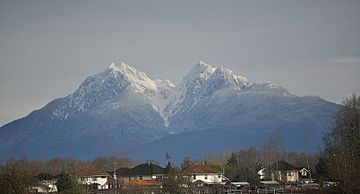
Golden Ears is a famous mountain peak located north of Maple Ridge in British Columbia, Canada. You can see this mountain from many parts of the western Lower Mainland. It's a special part of Golden Ears Provincial Park.
The mountain is known for its unique look, with two peaks that some people think look like ears. When the sun sets, these peaks can glow with a golden light, which might be how the mountain got its name.
Discovering Golden Ears Mountain
Golden Ears mountain stands tall at 1,716 m (5,630 ft) (about 5,630 feet) above sea level. It's part of the Garibaldi Ranges. This mountain is a popular spot for hikers and nature lovers. It offers amazing views of the surrounding area.
The Story Behind the Name
The name "Golden Ears" has an interesting history. Originally, the area that includes Golden Ears, Edge Peak, and Blanshard Peak was called The Golden Eyries. An "eyrie" is a nest built by a large bird of prey, like an eagle. Some people believe the name came from golden eagles seen near the summit.
Over time, the name Golden Eyries slowly changed into Golden Ears. This change happened because the mountain's two peaks look a bit like ears. Also, these peaks often turn a beautiful golden color when the sun shines on them, especially at sunset.
For a while, in the 1930s or 1940s, the government tried to rename the whole area to Mount Blanshard. They also gave specific names to the other peaks, like Edge Peak and Blanshard Peak. But people living in the Lower Mainland always continued to call the mountain, the park, and the whole area Golden Ears. Because of this, the official name for the twin-peaked summit eventually became Golden Ears again.
Hiking and Exploring Golden Ears
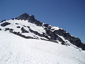
If you love hiking, there's a challenging trail that goes all the way to the peak of Golden Ears. The trail starts from the West Canyon Parking Lot. It's a tough climb, but it's very rewarding!
Along the way, there's a campground where you can stop and rest, about halfway up the mountain. There's also an emergency shelter on Panorama Ridge, which is close to the highest peak. This shelter is there for safety, in case hikers need a place to rest or take cover.
 | Emma Amos |
 | Edward Mitchell Bannister |
 | Larry D. Alexander |
 | Ernie Barnes |


