Pitt River Bridge facts for kids
Quick facts for kids Pitt River Bridge (2009) |
|
|---|---|
 |
|
| Coordinates | 49°14′54″N 122°43′47″W / 49.2482°N 122.7297°W |
| Carries | Seven lanes of British Columbia Highway 7, pedestrians and bicycles |
| Crosses | Pitt River |
| Locale | Port Coquitlam Pitt Meadows |
| Maintained by | British Columbia Ministry of Transportation |
| Preceded by | Pitt River Bridge (1957, 1978) |
| Characteristics | |
| Design | Cable-stayed bridge |
| History | |
| Opened | October 4, 2009 |
| Statistics | |
| Daily traffic | 79,000 |
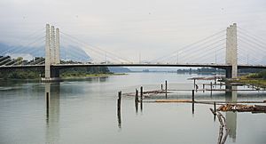
The Pitt River Bridge is a modern bridge located in British Columbia, Canada. It stretches across the Pitt River, connecting the cities of Port Coquitlam and Pitt Meadows. This bridge is a key part of Highway 7, also known as Lougheed Highway. It helps many cars, bikes, and people cross the river every day. The current bridge opened on October 4, 2009. It cost about $200 million to build.
What is a Cable-Stayed Bridge?
The Pitt River Bridge is a special type of bridge called a cable-stayed bridge. This means its main deck is held up by many strong cables. These cables connect directly from the deck to tall towers. It looks a bit like a giant harp! This design helps the bridge be very strong and stable. It also allows for a long main section without needing many supports from below.
The Old Pitt River Bridge
| Pitt River Bridge (1957, 1978) | |
|---|---|
 |
|
| Coordinates | 49°16′29″N 122°43′48″W / 49.2748°N 122.7301°W |
| Carries | Four lanes of British Columbia Highway 7, Lougheed Highway |
| Crosses | Pitt River |
| Locale | Port Coquitlam Pitt Meadows |
| Maintained by | British Columbia Ministry of Transportation |
| Followed by | Pitt River Bridge (second, 2009) |
| Characteristics | |
| Design | swing bridge |
| History | |
| Opened | 1957 (Westbound span), 1978 (Eastbound span) |
| Closed | October 4, 2009 (demolished November 2010) |
Before the current bridge, there were two older bridges. The first one opened in 1957. It was opened by the Premier of British Columbia, W. A. C. Bennett. The second bridge was built later, in 1978.
These old bridges were swing bridges. A swing bridge can open in the middle to let boats pass through. Sometimes, the middle part of the 1957 bridge would get stuck. This caused long lines of traffic, especially before the second bridge was built. This problem was fixed many years ago.
Each of the two old bridges had two lanes for cars. During busy times, like morning and evening rush hours, a special system was used. Three lanes would go in one direction, and only one lane would go the other way. This helped manage traffic flow better.
Building the New Bridge
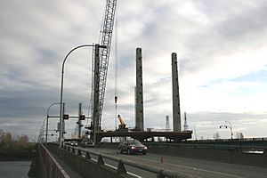
The old bridges were replaced with the new cable-stayed bridge. A new road system was also built. This new system helps traffic flow smoothly where the Mary-Hill Bypass meets Lougheed Highway.
On October 4, 2009, four lanes of the new bridge opened for cars. Soon after, it expanded to three lanes for traffic going west and four lanes for traffic going east. The new bridge was designed to be very flexible. It can even have an eighth lane in the future. It also has space for possible rapid transit, like a train or bus system.
The new bridge is also very tall. It allows boats up to 16 meters (about 52 feet) tall to pass underneath easily. The new bridge was built right between the two older bridges. After the new bridge was ready, the old ones were taken down. All of the old bridges were completely removed by November 22, 2010.
 | William M. Jackson |
 | Juan E. Gilbert |
 | Neil deGrasse Tyson |

