
Birkenhead River facts for kids
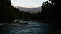
The Birkenhead River is an important river in British Columbia, Canada. It used to have other names like the Portage River, Pole River, and Mosquito River. This river is a major branch of the Lillooet River. The Lillooet River then flows into Harrison Lake, which connects to the big Fraser River. The Birkenhead River is about 50 kilometers (31 miles) long. It starts high up in the mountains south of Bralorne, British Columbia.
Contents
The River and Its People
The lower part of the Birkenhead River valley was once part of the Douglas Road. This old road was used during the Fraser Canyon Gold Rush. The area where the river flows is very important to the Lil'wat people. They are a subgroup of the Stʼatʼimc First Nation. The river is a huge source of salmon for them. Their community, Mount Currie, British Columbia, is located where the Lillooet and Birkenhead Rivers meet.
Owl Creek Mission
A few miles up the Birkenhead River, at a place called Owl Creek, there was once a major mission. This mission was run by the Oblate missionary group. Many Lil'wat people from the Pemberton Valley moved to this mission. Over time, they formed the community we now know as Mount Currie, British Columbia. Today, Owl Creek is a large neighborhood on the west side of the highway. This highway goes from Mount Currie to N'Quatqua (D'Arcy).
Gates River Area
About 25 kilometers (15 miles) from where the Birkenhead River meets the Lillooet, the Gates River valley branches off to the east. This area is near Poole Creek, which drains the western side of the Pemberton Pass. Birkenhead Lake is at the top of this pass. It is part of the Gates River system, which flows towards Anderson Lake (British Columbia) and Lillooet, British Columbia.
In this area, there is a large stone with a foot-shaped mark on it. This stone is still there today. Alexander Caulfield Anderson saw it when he traveled through in 1846. The story says that one of the "transformers" (a powerful being in some First Nations stories) stamped his foot on the rock. This created a boundary between people from the Canyon and those from the Lillooet River valley. These groups had met there to trade salmon and weaving reeds. This special stone is on private land, so it cannot be visited.
Birkenhead Lake Park
Birkenhead Lake is a beautiful lake that feeds the Birkenhead River from its south end. It also connects to a side valley at its north end. This side valley leads back to the Gates Valley through Blackwater Creek. Birkenhead Lake is protected by a small provincial park. This means the lake and its immediate surroundings are kept safe. However, the tall mountains around the lake are not part of the park. Above the lake, the Birkenhead's upper valley is surrounded by mountains. These mountains overlook the Pemberton Valley to the west and the mountains of upper Noel Creek near Bralorne, British Columbia.
Future of the River
Over time, a lot of silt (fine sand and mud) has built up in the eastern part of the reserve. This land is between the Birkenhead and Lillooet Rivers. Because of this silt, the land is quite new. In the future, the Birkenhead River will likely flow directly into the Lillooet River. Right now, it flows into Lillooet Lake on its own, a short distance from the Lillooet River's mouth. This change is happening because of how the river carries and drops sediment.
How the River Got Its Name
The Birkenhead River was named after the HMS Birkenhead. This ship is famous in British Naval history. In February 1852, the ship sank. But the story is well-known because the women and children on board were saved first. They got into the few lifeboats. Meanwhile, the soldiers bravely stood in their ranks on the ship's deck. The commanding officer, Lieutenant Colonel Alexander Seton, died in the sinking. He was related to Alexander Caulfield Anderson, an officer of the Hudson's Bay Company. Anderson was the one who named the lake and river after Seton to honor him.
Images for kids
-
Birkenhead River

