Chilcotin Plateau facts for kids
Quick facts for kids Chilcotin Plateau |
|
|---|---|

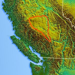
Location of the Chilcotin Plateau
|
|
| Location | British Columbia, Canada |
| Coordinates | 52°10′00″N 123°25′00″W / 52.16667°N 123.41667°W |
| Part of | Fraser Plateau |
| Geology | Flood basalt |
The Chilcotin Plateau is a large, flat area of land in British Columbia, Canada. It's part of an even bigger region called the Fraser Plateau. This special area is located between the Fraser River and the tall Coast Mountains. It gets its name from the Chilcotin River, which flows through it.
The Chilcotin Plateau is very similar to the Chilcotin District, a region known as "the Chilcotin." This district includes not only the flat plateau but also some nearby mountains.
Contents
Where is the Chilcotin Plateau?
The Chilcotin Plateau is surrounded by other interesting places. To the east, across the Fraser River, you'll find the Cariboo Plateau. To the north, past the West Road (Blackwater) River, is the Nechako Plateau.
To the west and south, the Chilcotin Plateau meets different parts of the Coast Mountains. This includes the Chilcotin Ranges, which are located along the plateau's southwest side.
Mountains and Volcanoes
The Chilcotin Plateau isn't just flat land. It also includes some cool mountain ranges. These include the Rainbow Range, which is near Bella Coola.
There are also the Ilgachuz Range and Itcha Range. These are both major shield volcanoes. A shield volcano is a type of volcano that looks like a warrior's shield lying on the ground, with gentle slopes. Some maps also include the Camelsfoot Range, north of Lillooet, as part of the Chilcotin Plateau.
Rivers and Waterways
Most of the water on the Chilcotin Plateau flows into the Chilcotin River. This river has many smaller rivers that flow into it, called tributaries. The biggest tributaries are the Chilanko River and the Chilko River.
On the eastern edge of the plateau, a stream called Churn Creek flows directly into the Fraser River. On the western side, rivers like the Dean, Homathko, and Atnarko River start on the Chilcotin Plateau before flowing through the Coast Mountains.
How the Plateau Formed
The Chilcotin Plateau is made up of a type of volcanic rock called basaltic lava. This lava comes from something called the Chilcotin Group. This group of related volcanic rocks formed at about the same time as the Fraser Plateau.
The plateau stretches along the Garibaldi Volcanic Belt in the Coast Mountains. Scientists believe the volcanism that created the Chilcotin Plateau happened because the Earth's crust was stretching. This stretching happened behind the Cascadia subduction zone, which is a place where one of Earth's plates is sliding under another.
See also
 In Spanish: Meseta de Chilcotin para niños
 | George Robert Carruthers |
 | Patricia Bath |
 | Jan Ernst Matzeliger |
 | Alexander Miles |

