Chilcotin Ranges facts for kids
Quick facts for kids Chilcotin Ranges |
|
|---|---|

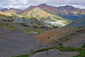
The Chilcotin Ranges show bright colours from minerals
|
|
| Dimensions | |
| Area | 9,616 km2 (3,713 sq mi) |
| Geography | |
| Country | Canada |
| Province | British Columbia |
| Range coordinates | 51°10′0″N 123°15′0″W / 51.16667°N 123.25000°W |
| Parent range | Pacific Ranges |
| Borders on | Chilcotin Plateau, Waddington Range |
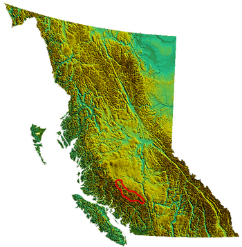
The Chilcotin Ranges are a group of mountains in British Columbia, Canada. They are part of the larger Coast Mountains, specifically a section of the Pacific Ranges. These mountains are located on the side of the Pacific Ranges that faces inland, right next to the Interior Plateau of British Columbia.
The Chilcotin Ranges stretch from the head of the Klinaklini River in the northwest to the Fraser River near Lillooet in the southeast. To the north, they meet the Interior Plateau, and to the south, they are bordered by the Bridge River. Some people think they don't go all the way to the Fraser River, but end at the Yalakom River instead.
The Chilcotin Ranges are not just one mountain range. They are a collection of many different ranges, each with its own unique features. The three main named subranges are:
- Dickson Range
- Shulaps Range
- Camelsfoot Range (sometimes considered part of the Interior Plateau)
To the west, some people also include the Pantheon Range and the Niut Range as part of the Chilcotin group. South of these are the Waddington Range and the Homathko Icefield.
What are the Provincial Parks?
In recent years, several large provincial parks and protected areas have been created in the central-eastern part of the Chilcotin Ranges. A provincial park is a special area of land protected by the government, often for its natural beauty, wildlife, or historical importance. These parks help keep the environment safe and allow people to enjoy nature.
The parks in this area include:
- Big Creek Provincial Park
- Tsʼilʔos Provincial Park (the '?' is a special sound, like a quick stop in your throat)
- Spruce Lake Protected Area
- Churn Creek Protected Area
Why is the Spruce Lake Protected Area Important?
This area is often called the "South Chilcotin," even though that's not its official name. For a long time, since the 1930s, there has been a disagreement about what to do with this land. Some people want to protect it as a natural area, while others want to use its resources, like timber or minerals.
A provincial park was created here in the 1990s. However, in 2007, its protection level was lowered, and it became the Spruce Lake Protected Area. This means it has less protection than a full provincial park. The future of this area is still being discussed, and the protected land is much smaller than what was first suggested back in the 1930s.
Historically, this region was a hunting ground for local Indigenous peoples. Chief Hunter Jack of the Lakes Lillooet people hunted big game here, sharing the land with hunters from the Tsilhqot'in people. They made peace in the early 1800s after a long war, and sharing this land was part of that agreement. Trails from the Bridge River Country crossed these mountains, leading to places like Taseko Lake and Chilko Lake in the Chilcotin Country. Other trails went east to the Fraser River.
Even though not many profitable mines have been found in the protected area itself, there was a lot of excitement about gold in 1941 near the Shulaps Range. Miners tried very hard to reach these high-up claims. These claims were put aside during World War II but are now being worked as the Blue Creek Mine. Other potential mining sites include copper deposits on Red Mountain, which is the highest peak in the Camelsfoot Range.
The Spruce Lake area is very special because of its unique landscape and environment. It stands out even in a region that is already wild and beautiful. This is why people have wanted to protect it for a long time. Nearby ranges like the Dickson, Shulaps, and Bendor Ranges are not as protected and have seen a lot of logging.
Many environmental groups hope that creating Tsʼilʔos and Big Creek Provincial Park will help protect the Spruce Lake Protected Area even more. Some people, like hunting guide Ted Choate, want to combine all these parks, plus the Churn Creek Protected Area and other surrounding lands, into a large National Park. A National Park would offer the highest level of protection. However, industries and the government want to continue allowing some resource use while also planning for the future of the land.
What Resources are in the Area?
There aren't many active mines in the Chilcotin Ranges, even though the area has copper and possibly uranium. For over 100 years, explorers haven't found enough valuable minerals to start big mines.
However, in recent years, clearcut logging has moved into the edges of the protected areas. Clearcut logging means cutting down all the trees in a section of forest. This logging feeds sawmills in Lillooet, British Columbia and other towns. This has caused disagreements between people who want to protect the environment and those who want to use the resources. To try and solve these problems, a group called an Integrated Resource Management Process Unit was formed. This group tries to help different groups work together to plan how the land is used.
 | Valerie Thomas |
 | Frederick McKinley Jones |
 | George Edward Alcorn Jr. |
 | Thomas Mensah |


