Tŝilhqox Biny facts for kids
Quick facts for kids Tŝilhqox Biny |
|
|---|---|
| Chilko Lake | |
 |
|
| Location | Chilcotin District, west-central British Columbia |
| Coordinates | 51°16′N 124°3′W / 51.267°N 124.050°W |
| Primary outflows | Chilko River |
| Basin countries | Canada |
| Max. length | 65 kilometres (40 mi) |
| Max. width | 5.2 kilometres (3.2 mi) |
| Surface area | 184 km2 (71 sq mi) |
| Average depth | 108 m (354 ft) |
| Max. depth | 366 m (1,201 ft) |
| Water volume | 21.2 cubic kilometres (5.1 cu mi) |
| Residence time | 7.6 years |
| Shore length1 | 181 km (112 mi) |
| Surface elevation | 1,172 metres (3,845 ft) |
| Islands | Duff Island |
| Settlements | None |
| 1 Shore length is not a well-defined measure. | |
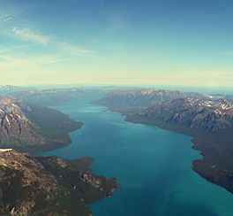
Tŝilhqox Biny, also known as Chilko Lake, is a large lake in west-central British Columbia, Canada. It covers about 180 square kilometers (69 square miles). This beautiful lake is located at the start of the Chilko River on the Chilcotin Plateau.
Tŝilhqox Biny is about 65 kilometers (40 miles) long. It has a southwest arm that stretches for 10 kilometers (6 miles). Because it is very deep, it holds a huge amount of water, making it one of the largest lakes by volume in British Columbia. It is also the biggest lake in the province that sits more than 1,000 meters (3,280 feet) above sea level.
On March 11, 2019, the government of British Columbia and the Tsilhqot'in National Government officially changed the lake's name from Chilko Lake to Tŝilhqox Biny. This change honors the original language of the Tsilhqot'in people.
Contents
Exploring the Geography of Tŝilhqox Biny
Tŝilhqox Biny is located in a valley shaped by glaciers. This valley opens onto a wide plateau, not the ocean. This is different from the many fjords found along the British Columbia Coast. The mountains at the head of the lake are some of the tallest in the province.
Two large, deep glacial valleys connect Tŝilhqox Biny to the smaller Taseko Lakes to the east. The Taseko Lakes drain north, similar to the Chilko River. Both the Chilko and Taseko rivers eventually join the Chilcotin River, which then flows into the mighty Fraser River.
However, Tatlayoko Lake, located to the west across another mountain range, is not part of this river system. It drains into the Homathko River, which flows into Bute Inlet on the coast.
Protecting the Area: Tsʼilʔos Provincial Park
The area around Tŝilhqox Biny and the Taseko Lakes is a special protected place called Tsʼilʔos Provincial Park. This park includes the two valleys between the lakes. It is managed by both BC Parks (the provincial government's park branch) and the Xeni Gwet'in people. The Xeni Gwet'in live in the Nemaia Valley and are part of the Tsilhqotʼin people.
The name "Tsi'l?os" comes from the Tsilhqotʼin language. It refers to Mount Tatlow, a mountain that is 3,063 meters (10,049 feet) tall. This mountain stands between Chilko and Taseko Lakes. Even taller mountains are found at the head of Tŝilhqox Biny. These include Monmouth Mountain, which is 3,182 meters (10,440 feet) high, and Mount Good Hope, which reaches 3,242 meters (10,636 feet).
History Around Tŝilhqox Biny
The area around Tŝilhqox Biny has an important history, especially related to the Chilcotin War of 1864. During this conflict, some events and standoffs happened in the wilderness around the lake. The Xeni Gwet'in people, who live here today, are believed to be descendants of Klattasine, a main leader of the war.
Wild Horses and Conservation Efforts
The region near the lake is also home to some of the last remaining wild horses in the Chilcotin District. These horses once roamed in large numbers. Many of them live in an area called the Brittany Triangle, which is between the Chilko River and Taseko River.
In the early 2000s, there was a debate about protecting this area. Conservation groups wanted to preserve it, while some industries had other plans for using the land.
Hydroelectric Power Plans
In the 1950s, there were ideas to use Tŝilhqox Biny and the Chilko River to create hydroelectric power. However, these plans were not carried out because of the important salmon populations in the river.
Later, there were plans to divert water from the Taseko Lakes into Tŝilhqox Biny. The combined water from the Chilko and Taseko rivers would then flow into Tatlayoko Lake. From there, a series of dams would generate power along the Homathko River. However, these plans were stopped because Chilko and Taseko Lakes are now part of a provincial park, which protects them.
Even though the lakes are protected, the area between Tatlayoko Lake and Tŝilhqox Biny is not. So, plans for dams and power plants in the Homathko River canyon are still possible. One very large dam might be built near a place called "Murderer's Bar," which was the site of the first "battle" of the Chilcotin War.
See also
 In Spanish: Lago Chilko para niños
 | William M. Jackson |
 | Juan E. Gilbert |
 | Neil deGrasse Tyson |


