Tatlayoko Lake facts for kids
Quick facts for kids Tatlayoko Lake |
|
|---|---|
 |
|
| Location | Chilcotin District, British Columbia |
| Coordinates | 51°33′N 124°24′W / 51.550°N 124.400°W |
| Primary inflows | Homathko River |
| Primary outflows | Homathko River |
| Basin countries | Canada |
| Surface area | 9,880.8 acres (39.986 km2) |
| Average depth | 349.2 ft (106.4 m) |
| Max. depth | 688 ft (210 m) |
| Water volume | 4.26 cubic kilometres (1.02 cu mi) |
| Residence time | 17.9 years |
| Shore length1 | 175,050 ft (53,360 m) |
| Surface elevation | 2,714 ft (827 m) |
| Settlements | Tatlayoko Lake |
| 1 Shore length is not a well-defined measure. | |
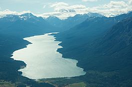
Tatlayoko Lake is a beautiful lake located in the western Chilcotin District of British Columbia, Canada. It is part of the Homathko River system. The lake runs north to south and is found just before the river enters a series of deep canyons, like the Great Canyon, on its way to the ocean at Bute Inlet. The small community of Tatlayoko Lake, British Columbia is located at the northern end of the lake.
Contents
Tatlayoko Lake's Past: A Look Back
Tatlayoko Lake is an important place for the Tsilhqotʼin People. They call the lake Talhiqox Biny, which means "lake" in their language. This area is part of the land claimed by the Xeni Gwet'in First Nation.
The Chilcotin War of 1864
In 1864, a Tsilhqot'in leader named Klattasine led a group of warriors. They attacked a team of workers who were building a gold-rush road called Waddington's Road in the Homathko canyons. This event marked the beginning of the Chilcotin War. To help, soldiers and even the colony's governor traveled to the Chilcotin area by way of Tatlayoko Lake.
Modern Water Projects
Today, Tatlayoko Lake and the Homathko River are part of plans for future water projects. There are ideas for diverting water from Chilko Lake, which is across the mountains to the east. Also, permits have been given to use the Homathko River downstream from the lake to create electricity. This is done using a method called "run-of-the-river" hydroelectricity.
How Tatlayoko Lake Got Its Name
The name of Tatlayoko Lake has changed over time. Early maps of British Columbia showed different spellings for the lake.
Early Maps and Names
The first detailed map of British Columbia was made in 1871. On this map, the lake was called Ta tlah co Lake. This name was very similar to the Tsilhqot'in name, which is Telhiqox. A few years later, in 1878, a geologist named George Mercer Dawson studied the area. His report used the spelling Tatlayoco. Maps from the 1880s and 1890s continued to use variations of Tatlahco Lake, while scientific reports often used Dawson's spelling.
Standardizing the Name
Having many different spellings for the same place was common back then. So, in 1897, the Geographical Names Board of Canada was created. Their job was to make all place names standard. They had rules for naming places, such as:
- The first name published should be preferred.
- If a local Indigenous name is used, its spelling should sound like the real pronunciation.
- The name should not have extra letters that are not pronounced.
- Any hard "c" sound should be changed to a "k".
The Geographic Board of Canada did not know about the earlier name Tatlahco. They thought it was a name for a different river. They only knew about Dawson's spelling, Tatlayoco. So, in 1911, they made Tatlayoko the official name. They changed the hard "c" to a "k" as per their rules. This is how the lake got its current spelling, even though Tatlahco was published first and sounds more like the original Tsilhqot'in word. According to their own rules, the name should have been spelled Tatlako.
 | Janet Taylor Pickett |
 | Synthia Saint James |
 | Howardena Pindell |
 | Faith Ringgold |


