Homathko River facts for kids
Quick facts for kids Homathko River |
|
|---|---|

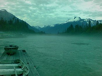
Early morning on the Homathko
|
|
|
Mouth of Homathko River
|
|
| Native name | |
| Country | Canada |
| Province | British Columbia |
| Physical characteristics | |
| Main source | Unnamed lake Coast Mountains 2,126 m (6,975 ft) 51°42′39″N 124°36′15″W / 51.71083°N 124.60417°W |
| River mouth | Pacific Ocean Bute Inlet, Coast Mountains 0 m (0 ft) 50°55′52″N 124°51′37″W / 50.93111°N 124.86028°W |
| Length | 144 km (89 mi) |
| Basin features | |
| Basin size | 5,680 km2 (2,190 sq mi) |
The Homathko River is a big river in the southern Coast Mountains of British Columbia, Canada. It is special because it cuts through these mountains. The river flows from the interior Chilcotin Country all the way to the Pacific Ocean.
The Homathko River ends at the top of Bute Inlet. This is a long, narrow arm of the sea, like a fjord. The river valley is very hard to travel through. Its waters are freezing cold, and the valley has lots of devil's club plants. Many grizzly bears also live here.
Contents
River's Path and Surroundings
The mountains around the Homathko River are some of the tallest in the Coast Mountains. These include Mount Waddington to the west and Mount Queen Bess to the east. Mount Waddington is in the Waddington Range. Mount Queen Bess is next to the Homathko Icefield.
Other mountain ranges near the river include the Niut Range and the Whitemantle Range. The Pantheon Range is also nearby. The area that the Homathko River drains, called its drainage basin, is about 5,680 square kilometers (2,193 square miles).
Where the River Starts and Flows
The Homathko River starts from a lake in the northern Niut Range. It first flows northeast towards the Chilcotin Plateau. It briefly touches the plateau near Tatla Lake. Then, it turns south to Tatlayoko Lake. This lake is west of Chilko Lake, which is part of the Chilcotin River system.
From Tatlayoko Lake, the Homathko River flows south and west. It cuts through the Pacific Ranges. Many smaller rivers join it, like the Nostetuko and Stonsayako Rivers. Further downstream, Mosley Creek joins the Homathko.
As the river goes through the Waddington Range, it flows through a narrow area called Waddington Canyon. Finally, it empties into Waddington Harbour, which is the very end of Bute Inlet.
Some Indian reserves belonging to the Homalco (or Homalko) First Nation are located where the river meets the sea.
History of the Homathko River Area
The area around Bute Inlet and the lower parts of rivers like the Homathko has long been home to the Xwe’malhkwu people. They are also known as the Homalco First Nation. The Xwe’malhkwu are part of the K'omoks people. They speak a dialect of the Mainland Comox language. This language is part of the Coast Salish family.
In the late 1800s, outside influences began to change Xwe’malhkwu culture. Indian Residential schools especially harmed their traditional culture and language.
The upper part of the Homathko River basin was home to the Tsilhqot'in (Chilcotin) people. The Tsilhqot'in and Xwe’malhkwu sometimes traded. However, they were often in conflict.
Both the Xwe’malhkwu and Tsilhqot'in peoples never gave up their lands. They are now working with British Columbia and Canada to make treaties. Both groups claim ownership of parts of the Homathko River's watershed.
Early Exploration and Conflict
In 1861, Alfred Waddington wanted to build a road to the gold fields. He sent people to survey the Homathko River and Bute Inlet. This road, called Waddington's Road, was meant to compete with another road to the Cariboo Gold Rush area.
In 1864, a conflict happened near where Mosley Creek meets the Homathko River. A group of Tsilhqot'in people clashed with Waddington's survey team. Fourteen members of the survey team died. This event started the Chilcotin War of 1864.
A townsite called Port Waddington was planned in this area. It was part of Alfred Waddington's road project. Some land was sold, but the town was never built.
Railroad Plans
In 1871, the Crown Colony of British Columbia joined Canadian Confederation. One condition was building a railroad across Canada. The Canadian Pacific Railway looked at several possible routes.
One route would have followed the Homathko River to Bute Inlet. It would then cross Sonora Island and Quadra Island to reach Vancouver Island. From there, it would go along the east coast of Vancouver Island to Victoria.
After many discussions, Burrard Inlet was chosen for the railway's end point. This led to the creation of the City of Vancouver. The Homathko River route was not used.
In 1890, another group explored the Homathko River route. Even with memories of the Chilcotin War, they reached Tatla Lake without major problems.
Wildlife in the Homathko River
The Homathko River is very important for fish. Many Chum and Pink salmon are born here. Other fish include Coho and Chinook salmon. You can also find Rainbow and Steelhead trout, Cutthroat trout, Bull trout, and Dolly Varden trout.
In 2008, nine special areas were set aside in the Homathko watershed for Grizzly Bears. These are called Wildlife Habitat Areas.
Plans for Hydroelectric Power
There have been many ideas to use the Homathko River for hydroelectric power. The river has a huge potential to create electricity. One big plan would have moved water from the Taseko Lakes and Chilko Lake into the Homathko system. This would happen through Tatlayoko Lake.
A series of dams on the Homathko and its smaller rivers would have used this extra water. This could have made a lot of power. However, the creation of Tsʼilʔos Provincial Park and Big Creek Provincial Park stopped this large plan. Chilko Lake and Taseko Lakes are now protected. Their water cannot be moved, partly to protect the salmon fishery.
But, some dams planned for the Homathko Canyon are still possible. If built, the biggest dam would be in Waddington Canyon. This spot is known for being where the Chilcotin War began.
Protected Natural Areas
Some parts of the Homathko River's watershed are protected. These include Homathko Estuary Provincial Park and Homathko River-Tatlayoko Protected Area.
Rivers Joining the Homathko
Here is a list of some rivers and creeks that flow into the Homathko River, starting from the mouth and going upstream:
- Cumsack Creek
- Heakamie River
- Jewakwa River
- Brew Creek
- Whitemantle Creek
- Scar Creek
- Klattasine Creek
- Tiedemann Creek
- Mosley Creek
- Tellot Creek
- Mercator Creek
- Scimitar Creek
- Five Finger Creek
- Crazy Creek
- Twist Creek
- Hell Raving Creek
- Middle Lake
- Razor Creek
- Valleau Creek
- Bluff Lake
- Sapeye Lake
- Nude Creek
- Ottarasko Creek
- Tatlayoko Lake
- Lincoln Creek
- Skinner Creek
- Cochin Creek
- Quakie Creek
See also
 In Spanish: Río Homathko para niños
 | Shirley Ann Jackson |
 | Garett Morgan |
 | J. Ernest Wilkins Jr. |
 | Elijah McCoy |


