
Chilcotin River facts for kids
Quick facts for kids Chilcotin River |
|
|---|---|

Chilcotin in Farwell Canyon
|
|
| Country | Canada |
| Province | British Columbia |
| Physical characteristics | |
| Main source | Itcha Lake Northeast of Itcha Mountain 5,223 ft (1,592 m) 52°47′09″N 124°45′51″W / 52.78583°N 124.76417°W |
| River mouth | Fraser River Upstream from Gang Ranch 1,152 ft (351 m) 51°44′22″N 122°24′03″W / 51.73944°N 122.40083°W |
| Length | 241 km (150 mi) |
| Basin features | |
| Basin size | 19,300 km2 (7,500 sq mi) |
The Chilcotin River is a long river in southern British Columbia, Canada. It stretches for 241 kilometers (150 miles). This river is a major branch, called a tributary, of the larger Fraser River.
The name Chilcotin comes from the Tŝilhqot’in people. It means "ochre river people." Ochre is a special mineral that Indigenous communities used to make paint or dye.
The Chilcotin River, along with the Chilko River and Taseko River, forms the Chilcotin River watershed. A watershed is an area of land where all the water drains into a single river or lake. This watershed covers a huge area of 19,200 square kilometers (7,400 sq mi). It drains the Chilcotin Plateau, a large flat area of land. The Chilcotin River starts near Itcha Mountain and flows southeast. It eventually joins the Fraser River near Williams Lake.
The Chilcotin River area is special because of its unique land, weather, and plants and animals. Many different types of plants and animals live here. The river is important for Canadian Fisheries and local communities like Alexis Creek, Hanceville, and the Tŝilhqot’in Nation.
However, the river faces some environmental problems. These include more floods, changes in water quality, fewer steelhead trout, and more mountain pine beetle outbreaks.
Contents
Natural Landscape & Climate
How the Land Was Formed
The rocks in the Chilcotin River valley tell us how the river formed. Scientists think the river's path was created millions of years ago. The lower part of the Chilcotin River has special rocks called the Wineglass assemblage. These rocks are very old and are found with other ancient rocks.
The Wineglass assemblage has a unique structure. It is similar to other rock formations found across British Columbia. These rock groups share similar types of rocks and how they are layered.
River's Journey
The Chilcotin River starts with many small branches. These branches gather water from little creeks and lakes. The river flows through different areas, picking up more water along the way.
One important spot is where the Chilko River and its main branch, the Taseko River, meet the Chilcotin River. This happens between Redstone and Alexis Creek. At this point, the Chilcotin River flows about 60 meters (200 feet) below the land's surface.

The meeting point of the Chilko and Taseko rivers is popular with visitors. The Taseko River looks milky, while the Chilko River is a clear blue. This spot is great for whitewater rafting!
As the Chilcotin River continues, it flows through deep valleys. It passes through Bull Canyon, Farwell Canyon, and Big Creek Canyon. Finally, it joins the Fraser River.
River Flow
From 1971 to 2018, the Chilcotin River's average water flow was 102 cubic meters per second. This measurement was taken between Big Creek and where it meets the Fraser River. Since 2018, there haven't been government stations measuring the river's flow.
Most of the winter rain and snow in the Chilcotin area falls as snow. When this snow melts in spring and early summer, it causes a "freshet." This is when the river's water level rises a lot due to the melting snow. The river's highest monthly flow can be almost 10 times greater than its lowest flow.
Protected Areas
The Chilcotin River flows near several protected areas. These include Bull Canyon Provincial Park, Big Creek Ecological Reserve, and Junction Sheep Range Provincial Park. These parks help protect the natural environment around the river.
Main Branches
The Chilcotin River has seven main branches, also called tributaries. The largest of these is the Chilko River. The Chilko River is special because it carries more water than the Chilcotin River itself! These branches are all part of the larger Fraser River system.
| Tributary Name | Location of Confluence |
|---|---|
| Moore Creek | 10 km below Chilcotin Falls |
| Punkutlaenkut Creek | 7 km below Moore Creek |
| Clusko River | 8 km above Chilcotin Lake |
| Palmer Creek | western end of Chilcotin Lake |
| Chilanko River | 15.5 km above Chilko River |
| Chilko River | 5 km above Bull Canyon |
| Big Creek | Big Creek Canyon |
Weather
The average yearly temperature in the Chilcotin area has been slowly rising. Between 1951 and 1980, it was about 5.1°C (41.18°F). From 1981 to 2010, it rose to 6°C (42.8°F).
Experts predict that temperatures will continue to increase. By 2050, the average could be 7.5°C (45.5°F). By the end of the century, it might reach 10.9°C (51.62°F). The amount of rain and snow is also expected to increase. This data is for parts of the river, so the weather can be different along its entire length.
Cultural Importance
The Chilcotin River and its branches, especially the Chilko and Taseko Rivers, are very important to the Tŝilhqot’in Nation. The yearly journey of salmon up these rivers is vital for the Tŝilhqot’in people. Salmon provide food, are a key part of their culture, and help their economy.
To make sure salmon return each year, the Tŝilhqot’in National Government (TNG) and the Canadian Department of Fisheries and Oceans (DFO) work together. They fish in a way that helps salmon populations stay healthy. They also watch the rivers closely.
However, in recent years, fewer salmon have been returning. Because of this, the TNG decided to stop fishing for salmon in 2021. Fishing in the Chilcotin River is currently not allowed. This helps protect the salmon.
Ecology & Environment
Different Ecosystems
The Chilcotin River watershed has different types of ecosystems. About 40% of the area is covered by a "Sub-Boreal Pine-Spruce" zone. This means it has many pine and spruce trees.
Near where the river starts, it's a "Montane-Spruce" zone. This area has spruce trees that grow on mountains. As the river flows towards the Fraser River, it enters a "Bunchgrass" zone. This area has lots of grass. The river also passes through a "Douglas-Fir" zone, which has many Douglas-fir trees.
Wildlife
Salmon
The Chilcotin River is home to different types of salmon: coho, chinook, and sockeye. Coho and chinook salmon are considered threatened. This means their populations are at risk.
Salmon are a very important resource for the Tŝilhqot’in Nation. They provide food, are part of their traditions, and help their economy.
Steelhead Trout
The Chilcotin River also has a special type of steelhead trout (Oncorhynchus mykiss). These trout travel a very long way from the Bering Sea to the Chilcotin River every other autumn to lay their eggs. This makes them one of the longest-traveling trout in Canada.
The Chilcotin River steelhead are in great danger. They are classified as "endangered," meaning they are at extreme risk of disappearing forever. In 2018, only 58 of these trout returned to lay eggs. This was a huge drop and the lowest number ever seen.
Even though they are in great danger, the government has not yet fully protected them under the Species at Risk Act.
The number of steelhead trout is dropping for several reasons. These include being caught by other fisheries and having to compete with hatchery-raised fish in the ocean. Also, seals and sea lions sometimes eat them. Poor habitat quality and landslides blocking their paths to lay eggs also cause problems.
Environmental Challenges
Flooding
In July 2019, the Chilcotin River area had very heavy rainfall. This caused severe flooding and mudslides. Roads were covered, and some bridges were destroyed. Over 300 people were cut off, and 120 properties were damaged.
Water Quality
The quality of the river's water is important. Things like climate change and human activities can affect it. Recently, tests showed more metals in the Chilcotin River's water. Scientists are studying why this is happening. They think that more sediment in the water, possibly from changes in river flow, could be a reason.
Mountain Pine Beetles
British Columbia often has outbreaks of mountain pine beetles (MPB). These tiny beetles kill many trees, especially pine trees. This increases the risk of wildfires and harms the timber industry.
The Chilcotin Plateau has already had two big MPB outbreaks. One was in the 1970s and 80s, and another in the early 2000s. Researchers found that even though the main tree types weren't wiped out, future beetle outbreaks could make forests unusable for timber in the long run.
Images for kids
-
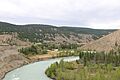
Chilcotin in Farwell Canyon
-
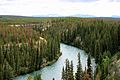
The Chilko River, a major branch of the Chilcotin, has clear blue water.
See also
 In Spanish: Río Chilcotin para niños
