Bute Inlet facts for kids
Quick facts for kids Bute Inlet |
|
|---|---|
| French: Baie Bute | |
 |
|
| Location | Strathcona RD, British Columbia |
| Coordinates | 50°39′09″N 124°53′10″W / 50.65250°N 124.88611°W |
| Primary inflows | Homathko River, Southgate River |
| Primary outflows | Cordero Channel (west) Calm Channel (south) |
| Max. length | 80 kilometres (50 mi) |
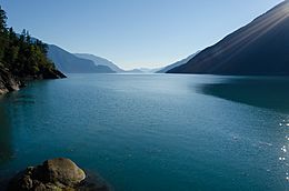
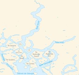
Bute Inlet is a long, narrow arm of the sea, called a fjord, located on the British Columbia Coast in Canada. It stretches about 80 kilometers (50 miles) from its start, where the Homathko and Southgate Rivers flow in, to its mouth near Stuart Island. The inlet is about 4 kilometers (2.5 miles) wide on average.
Bute Inlet is famous for its amazing wilderness and beautiful scenery. In the upper parts of the inlet, mountains rise over 2,700 meters (9,000 feet) above the sea. Not many people visit this wild area. However, in recent years, tourists from all over the world have started coming to see grizzly bears in their natural home and explore the inlet's wild beauty.
Contents
Why is it Called Bute Inlet?
Bute Inlet was named after John Stuart, 3rd Earl of Bute. He was the Prime Minister of Great Britain from 1762 to 1763. His grandson, Charles Stuart, was a sailor on Captain George Vancouver's ship, the Discovery.
History of Bute Inlet
Waddington's Road and the Chilcotin War
Bute Inlet played an interesting part in the early history of the Colony of British Columbia. A businessman named Alfred Waddington wanted to build a shorter and easier road to the Cariboo goldfields. At the time, people used longer routes through the Fraser Canyon.
Waddington planned to build a wagon road from the top of Bute Inlet, following the Homathko River, to the Chilcotin Plateau. From there, it would go east to the goldfields. His idea was that steamships from Victoria would bring travelers to the inlet. Then, people would use his toll road to travel overland. He even got permission for a townsite at the head of the inlet, called Port Waddington.
Conflict with the Tsilhqot'in Nation
Building the road led to conflict with the Tsilhqot'in Nation. Some Tsilhqot'in warriors were working on the road because there was a famine in their land. Waddington's foreman made threats against them. Because of these threats, the warriors, led by Klattasine, attacked Waddington's work party. Three men managed to escape, even though they were badly hurt.
Their reports led to expeditions by troops from Victoria and volunteers from the Cariboo. This conflict became known as the Chilcotin War of 1864. It ended when Klattasine surrendered, believing he would be given a fair hearing. However, he was later executed near modern-day Quesnel.
Proposed Canadian Pacific Railway Route
Later, the Bute Inlet route was considered for the main line of the Canadian Pacific Railway (CPR). This plan would have involved a lot of blasting along the west shore of the inlet. It also would have needed many bridges to reach Vancouver Island near Campbell River.
However, the CPR chose a different route through the Fraser Canyon to a new port city at Burrard Inlet, which became Port Moody. There were a few reasons why Bute Inlet was not chosen. One reason was the lasting impact of the Chilcotin War. Another was the very steep slopes in the Homathko River canyon, which would have made building the railway very difficult and expensive. The cost of blasting along the inlet and building deep-water bridges was also a factor.
Where is Bute Inlet Located?

Bute Inlet is located in the Coast Land District, Range 1, in British Columbia. It is part of the Sunshine Coast Forest District. This area is also within the mainland part of the Strathcona Regional District. This district handles local services like building permits in rural areas.
The inlet is also within the traditional territories and land claims of several First Nations. These include the Homalco, Klahoose, Kwiakah, and We Wai Kai First Nations.
Geology of Bute Inlet
Bute Inlet is a classic example of a fjord. Fjords are long, narrow, deep inlets of the sea, formed when glaciers carve out valleys. This happened during the Holocene epoch.
Bute Inlet is one of the deepest fjords in British Columbia, reaching a depth of about 660 meters (2,165 feet). It has a shallower section, called a sill, which is about 220 meters (720 feet) deep. Most of the fresh water flowing into the inlet, about 95%, comes from the Homathko and Southgate rivers at its head. There is also an underwater channel system in the fjord's basin that carries sediment.
See also
 In Spanish: Bute Inlet para niños
 | James B. Knighten |
 | Azellia White |
 | Willa Brown |


