Calm Channel facts for kids
Quick facts for kids Calm Channel |
|
|---|---|
| French: Canal Calme | |

Calm Channel
|
|

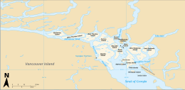
Calm Channel surrounds the Rendezvous Islands (centre right)
|
|
| Location | Discovery Islands, British Columbia |
| Coordinates | 50°17′51″N 125°03′48″W / 50.29750°N 125.06333°W |
| Type | Strait |
| Primary inflows | Bute Inlet (north) Pryce Channel (east) |
| Islands | Rendezvous Islands |
| Sections/sub-basins | Drew Passage |
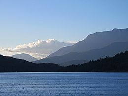
Calm Channel is a natural waterway in British Columbia, Canada. It's part of the Discovery Islands, a group of islands on Canada's west coast. This channel is like a busy water highway, helping boats travel between the islands.
Contents
Exploring Calm Channel's Location
Calm Channel is surrounded by several large islands. These include Maurelle Island, Raza Island, Read Island, Sonora Island, Stuart Island, and West Redonda Island.
Nearby Waterways
Many other water passages connect to Calm Channel.
- To the north, you'll find Cordero Channel and Bute Inlet.
- To the east are Raza Passage and Deer Passage.
- South of Calm Channel are Lewis Channel and Sutil Channel.
- To the southwest, there's Whiterock Passage.
- And to the northwest, you can find Hole in the Wall.
Drew Passage
A special part of Calm Channel is called Drew Passage. This section is located between the Rendezvous Islands and the northern tip of Read Island.
How Water Flows in Calm Channel
Water mainly flows into Calm Channel from two places: Bute Inlet (from the north) and Pryce Channel (from the east). The water from Pryce Channel reaches Calm Channel through Deer Passage and Raza Passage.
Once the water is in Calm Channel, it moves out slowly into other nearby channels and straits. Because the water mostly flows south, Calm Channel is not officially part of the Salish Sea itself. However, it is considered part of the Salish Sea's watershed. This means that water from Calm Channel eventually makes its way into the Salish Sea.
 | Kyle Baker |
 | Joseph Yoakum |
 | Laura Wheeler Waring |
 | Henry Ossawa Tanner |


