Read Island facts for kids

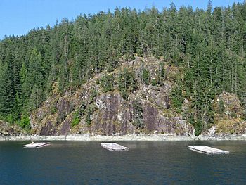
Oyster farming at Read Island
|
|

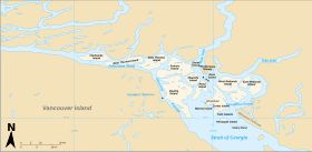
Location of Read Island (centre right)
|
|
| Geography | |
|---|---|
| Coordinates | 50°11′00″N 125°05′00″W / 50.18333°N 125.08333°W |
| Archipelago | Discovery Islands |
| Administration | |
| Province | British Columbia |
| Regional district | Strathcona |
Read Island is a beautiful island located in British Columbia, Canada. It is part of a group of islands called the Discovery Islands. These islands are found between a larger island called Vancouver Island and the mainland of Canada. Read Island sits between two important waterways: the Strait of Georgia and Johnstone Strait.
What's in a Name?
Read Island got its name around 1864. A captain named Daniel Pender, who was in charge of a ship called the Beaver, named it. He chose the name to honor Captain William Viner Read. At that time, Captain Read worked for the United Kingdom Hydrographic Office, which creates sea maps. The southern tip of the island, Viner Point, was also named after him.
Exploring Read Island's Location
Read Island is nestled among several other islands. It lies between Quadra Island and Cortes Island. To its southeast is Maurelle Island, and to its southwest are the Rendezvous Islands.
The island is separated from its neighbors by narrow waterways called channels:
- Hoskyn Channel separates Read Island from Quadra Island.
- Whiterock Channel separates it from Maurelle Island.
- Sutil Channel separates it from Cortes Island.
On the eastern side of Read Island, you'll find a large inlet called Evans Bay. An inlet is a small arm of the sea, a lake, or a river that extends into the land.
Who Lives on Read Island?
About 80 people call Read Island home. The island is part of a local government area known as Electoral Area C within the Strathcona Regional District.
There's also a small community on the island called Read Island, British Columbia. This community is located on the eastern side of the island, close to its southern end. It's considered a "census-designated place," which means it's a specific area that the government counts for population statistics.
 | Jewel Prestage |
 | Ella Baker |
 | Fannie Lou Hamer |

