
Burrard Inlet facts for kids
Quick facts for kids Burrard Inlet |
|
|---|---|
| French: Baie Burrard | |

Aerial view of Burrard Inlet
|
|

Burrard Inlet
Location in British Columbia
|
|

Map of Burrard Inlet
|
|
| Location | Greater Vancouver, British Columbia, Canada |
| Coordinates | 49°17′55″N 123°05′07″W / 49.29861°N 123.08528°W |
| Type | Fjord |
| Part of | Salish Sea |
| Max. length | 44 kilometres (27 mi) |
| Sections/sub-basins | English Bay, False Creek, Indian Arm |
Burrard Inlet (French: Baie Burrard) is a long, narrow arm of the sea in southwestern British Columbia, Canada. It's like a deep, sheltered bay that stretches far inland. This inlet was formed thousands of years ago during the last Ice Age. It separates the big city of Vancouver from the tall North Shore Mountains. These mountains are home to communities like West Vancouver and North Vancouver.
Contents
A Look Back in Time
First Peoples and Early Explorers
For thousands of years, Burrard Inlet has been home to Indigenous peoples. The Musqueam, Squamish, and Tsleil-Waututh First Nations have lived here. They have a rich history and culture connected to this land and water.
The first Europeans to explore this area arrived in 1791. Juan Carrasco and José María Narváez sailed into the western part of the inlet. They were looking for the Fraser River but didn't find it.
A year later, in 1792, another explorer named Dionisio Alcalá Galiano explored the area. He realized there was a big river nearby. On June 19, 1792, he saw Burrard Inlet. Just days later, Captain George Vancouver named the inlet after his friend, Captain Sir Harry Burrard.
Where is Burrard Inlet?
Geography and Branches
Burrard Inlet stretches from the Strait of Georgia almost directly east to Port Moody. About two-thirds of the way from its mouth, a steep-sided branch called Indian Arm goes north. It runs between Belcarra and Deep Cove.
Near the mouth of the inlet, you'll find English Bay. From English Bay, a smaller inlet called False Creek branches off to the east.
How Big is It?
Burrard Inlet starts at a line between Point Atkinson and Point Grey in the west. It ends at Port Moody in the east. The Indian Arm branch goes even further north.
The inlet is about 31 kilometres (19 mi) long from the Strait of Georgia to Port Moody. If you include Indian Arm, it's about 44 kilometres (27 mi) long.
Cities and Crossings
Communities Along the Water
Many cities and towns are located along the shores of Burrard Inlet. These include Vancouver, West Vancouver, North Vancouver, Burnaby, and Port Moody.
Bridges and Ferries
People and goods cross the inlet using several ways:
- The Lions Gate Bridge was built in the 1930s. It's also called the First Narrows Bridge.
- The Ironworkers Memorial Second Narrows Crossing was built in 1960.
- A CNR railway bridge was built in 1969.
- The SeaBus is a passenger ferry that carries people across the water.
The inlet is widest (about 3 km or 1.9 mi) between the First and Second Narrows. This is also the busiest part of Vancouver's port.
Vancouver's Busy Port

Burrard Inlet's calm waters are protected from the open ocean. This makes it a perfect place for Vancouver's main port. Large ocean-going ships can easily use it.
While some parts of the shoreline have homes and shops, much of it is used for port activities. You can see railyards, terminals for big container ships, and oil refineries. Freighters often wait in English Bay before they load or unload cargo.
Even with all the port activity, some park areas remain forested. The steep slopes of Indian Arm are mostly untouched. In 2003, a rough hiking trail was finally completed around Indian Arm. It took one person many years to build it!
Major Crossings
The main ways to cross Burrard Inlet, from west to east, are:
- Lions Gate Bridge
- SeaBus
- Ironworkers Memorial Second Narrows Crossing
- Second Narrows Bridge
Images for kids
-
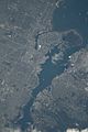
Part of the Outer Harbour (upper area), extending to part of the Central Harbour (lower area) on April 5, 2022. Taken from the International Space Station during Expedition 67; north is oriented towards the right and somewhat down.

See also
 In Spanish: Burrard Inlet para niños
