
False Creek facts for kids


False Creek is a short inlet (a small arm of the sea) located right in the middle of Vancouver. It acts like a natural border, separating the busy downtown area from other parts of the city. This waterway got its name from George Henry Richards during his survey work between 1856 and 1863. He first thought it was just a small creek, but when he realized it was a much larger inlet, he called it "False Creek."
At its eastern end, you'll find Science World, a popular science museum. Three major bridges cross False Creek from east to west: the Cambie Bridge, Granville Street Bridge, and Burrard Street Bridge. The Canada Line (a rapid transit train) also goes under False Creek through a tunnel near the Cambie Bridge. False Creek is one of four main bodies of water around Vancouver, along with English Bay, Burrard Inlet, and the Fraser River. In 1986, False Creek was a main location for Expo 86, a big world's fair.
False Creek South is a neighbourhood that stretches along the inlet. It starts near the Granville Bridge and goes east towards the Cambie Bridge. Southeast False Creek (also known as the Olympic Village) begins at the Cambie Bridge and extends to Main Street.
Contents
False Creek's Past: A Look Back

People have lived in the Lower Fraser region, where Vancouver is today, for a very long time—about 8,000 to 10,000 years! These first people are known as the Coast Salish. They lived here even before salmon started swimming in the rivers, which happened about 4,500 to 5,000 years ago. The land was rich with plants like Douglas fir and western red cedar. According to historian Lee Maracle, the Tsleil-Waututh people lived in what is now Vancouver.
European explorers first met the local Indigenous peoples in June 1792. Sadly, by 1812, many Indigenous people had become sick from diseases like smallpox, which came through trading routes. A big outbreak in 1782 killed two-thirds of the population. Before these diseases, it's thought that over 100,000 Indigenous people lived in the Lower Fraser area.
By 1812, the Tsleil-Waututh population was very small, with only 41 people left. They invited their neighbours, the Squamish, to live with them in Burrard Inlet. Soon after, a group of Tsleil-Waututh, led by Khatsalahnough, settled in what is now False Creek. At that time, there were large sandbars at the entrance to the creek. False Creek was a shared waterway for the Tsleil-Waututh, Musqueam, and Squamish peoples, who lived there all year.
Before Europeans arrived, False Creek reached as far east as what is now Clark Drive. It was a very important place for food, providing things like sea asparagus, berries, oysters, and clams. But as more land was added to the area for ports and factories, False Creek became polluted with sewage and waste from sawmills.
From 1894 to 1905, Alfred Wallace built ships on the north side of False Creek, near the Granville Street Bridge.
In 1913, the Squamish people living on the Kitsilano Reserve (a sandbar in False Creek) were forced to move. Their settlement was reportedly burned down. In 1916, this sandbar was built up to create Granville Island, making new land for factories. In 1917, the eastern part of False Creek was filled in to make space for the Canadian Northern Railway's Pacific Central Station. These railway stations helped Vancouver get the nickname "Terminal City." There was even talk of filling in more of the inlet until the 1950s, but it never happened.
False Creek was Vancouver's main industrial area until the 1950s, with many sawmills and small port businesses. As these industries moved away, the area around False Creek started to decline. In 1960, a large lumber facility on the south side of False Creek caught fire. It was Vancouver's first "five-alarm blaze," meaning all firefighters and equipment were needed to fight it for hours, but the facility was completely destroyed.
The future of False Creek South was then shaped by debates about building highways and renewing the city. In the 1960s, the city government planned to build highways through the city without much public input. At the same time, they tore down parts of the Strathcona neighbourhood to "renew" it. A group of citizens formed The Electors' Action Movement (TEAM) to stop the highways and change how decisions were made about land use. A key person was Walter Hardwick, a professor from UBC. He imagined turning this old industrial site into a lively community with homes and shops along the water.
Dr. Hardwick was elected to City Council in 1968. He led the city's redevelopment team and got the Canadian government, who owned Granville Island, to help. A big process involving public input and design followed. This process decided on important things like a public walkway along the water (seawall), different types of housing (condos, co-op housing, low-income housing), places for boats, and a lively market by the water. These plans became official in 1972. The way they planned the development was very new for Vancouver at the time. One-third of the area was set aside for housing, and the rest became parks, waterfront areas, and community spaces.
The North Shore of False Creek changed even more in the 1980s when it became the main site for Expo 86. After Expo, the government sold the North Shore land to Li Ka-shing, a businessman who wanted to build a high-density community there. Vancouver's experience with South False Creek and public involvement helped shape the North Shore into a lively, high-density area. For example, Li Ka-shing's company wanted to build private condo "islands" along the water. But the public and city planners insisted on a public walkway along the entire waterfront. The 1991 Official Development Plan allowed for many new buildings, along with public benefits like shops, parks, schools, community centres, daycares, and affordable housing. Since then, most of the north shore has become a new neighbourhood with many homes, adding about 50,000 new residents to downtown Vancouver.
On December 1, 1998, Vancouver City Council adopted "Blue ways" policies. These policies aim to create a waterfront city where land and water work together to meet the city's environmental, cultural, and economic needs in a good and fair way.
Southeast False Creek (SEFC) is the neighbourhood bordered by Cambie, Main, West 2nd Avenue, and False Creek. The 2010 Olympic Village, where athletes stayed during the 2010 Winter Olympics, is located here. The City of Vancouver plans to develop this neighbourhood into a residential area with homes and services for 11,000 to 13,000 people.
Fun on the Water: Sports and Recreation
False Creek is a very popular spot for many water activities! You can see people dragon boating, canoeing, kayaking, and riding public ferries. There are also charter ships and pleasure boats visiting. The creek has 10 marinas with space for 1,500 boats and several clubs for paddling or renting boats. Since 1986, False Creek has hosted the Canadian International Dragon Boat Festival and other paddling events.
Getting Around: Transportation
Two ferry companies, Aquabus and False Creek Ferries, offer daily services to many points along False Creek. Besides the three bridges and many bus routes, you can also cross False Creek underground using the Canada Line train. The tunnel runs between Olympic Village Station on the south shore and Yaletown–Roundhouse Station to the north.
Keeping it Clean: Environmental Issues
The water quality in False Creek is not safe for swimming, according to Vancouver Coastal Health. If you touch the water, it's a good idea to wash your hands or shower afterwards.
Sometimes, after heavy rains, raw sewage can flow directly into the Burrard Inlet.
Wildlife Returns to False Creek
After many years of industrial activity stopping, many shore and seabirds have returned to False Creek. You might spot cormorants, ducks, herons, kingfishers, owls, geese, crows, and gulls. Even harbour seals have come back! In an unusual event in May 2010, a grey whale swam into False Creek and traveled its whole length before going back out to the open waters of the Strait of Georgia.
However, some things still make it hard for more wildlife to return. These include leftover pollution from industries, sewage spills, and the seawall that lines much of the shore. This seawall doesn't offer much habitat for animals. The city is trying to rebuild natural shorelines in some areas and is working to fix the old sewer system.

Building Our City: Architecture and Urban Planning


The False Creek area has many different neighbourhoods, each with unique building styles and city planning ideas. The differences between the north and south shores of False Creek are easy to see in the buildings. These differences show how social, economic, and cultural changes shaped the city.
False Creek South: A Community Focus
The south shore of False Creek has changed a lot over time. It went from being an industrial area in the late 1800s and mid-1900s to the busy residential area it is today. The new development here, starting in the 1970s, happened at an important time for Vancouver. Citizens wanted a new kind of city, one that was more livable and diverse, not just focused on factories and efficiency. This neighbourhood, built on land owned by the city and federal government, allowed leaders to create a new type of space.
The buildings and city planning here aimed for variety, human-friendly sizes, open public spaces, and a mix of different types of people. This created a medium-density area with many different building designs, ways to own homes, fun activities, and transportation options. This makes it easy to move around and creates a beautiful landscape for everyone. Bike paths, parks, unique three-story homes, a public market, and keeping mountain views clear make South False Creek special. It was one of the first attempts to create a "livable" environment for Vancouver residents, rather than just focusing on making money. False Creek South is also home to False Creek Elementary School. Having a mix of incomes makes it a welcoming neighbourhood where community well-being is important. False Creek South has a strong sense of community.
False Creek South has a mix of housing types:
- 30% is low-income housing with subsidized (lower than market) rent. This includes housing from Metro Vancouver Housing and other organizations.
- 30% is co-op housing, where rent is based on income and is also subsidized.
- 10% is housing for people with special needs, also with lower-than-market rents.
- 30% is standard market-rate apartments and leasehold condos.
All of False Creek South is on leasehold land, which means the land is owned by the City of Vancouver.
Southeast False Creek (Olympic Village) mostly has market-rate apartments and modern condos, with a few co-ops and social housing units.
North False Creek: Modern Development
The north shore of False Creek, on the downtown peninsula, has developed in several stages. In the early 1980s, the government bought this land from the Canadian Pacific Railway. Before that, it was used for industrial purposes. The government planned to build a sports stadium (BC Place), shops, and many homes on this cleared land. The early development of the north shore, with strong government and business involvement, aimed mainly for economic profit.
BC Place and the many homes and shops made North False Creek look very different from its southern neighbour. The standardized condos and streets of the downtown area might seem more functional for city workers. This type of landscape, with its focus on large, modern spaces, helps keep residents and visitors connected to the city's economy. Even though early decisions shaped the look of North False Creek, the new owner, Li Ka-shing, has made efforts to create a more livable and accessible space, while still keeping the high number of homes and mixed-use areas.
False Creek North is home to Crosstown Elementary School and Elsie Roy Elementary.
Images for kids
-
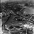
Aerial view, 1947. Granville Island is at the centre-right.

