Musqueam Indian Band facts for kids
Quick facts for kids
Musqueam
xʷməθkʷəy̓əm
|
|||
|---|---|---|---|
|
First Nations band
|
|||
|
|||

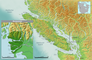
Territory of the Musqueam Indian Band
|
|||
| Country | Canada | ||
| Province | British Columbia | ||
| Government | |||
| • Type | Band council | ||
| Area | |||
| • Total | 1,448.88 km2 (559.42 sq mi) | ||
| Time zone | UTC-8 (PST) | ||
| • Summer (DST) | UTC-7 (PDT) | ||
| Postal code span |
V3H, V3J–N, V3V
V4C, V4K, V4G V5- to V7- |
||
| Area code(s) | 604, 778 | ||
| Ethnic groups | Coast Salish | ||
| Languages | Halkomelem, English | ||
The Musqueam Indian Band (pronounced MUS-kwee-əm) is a First Nations group in British Columbia, Canada. A "First Nation" is a term used in Canada for Indigenous peoples who are not Inuit or Métis. The Musqueam are special because their main community is the only First Nations reserve located right inside the City of Vancouver. Their traditional name is xʷməθkʷəy̓əm.
Contents
What Does the Name Musqueam Mean?
The name Musqueam comes from a special flowering plant called məθkʷəy̓. This plant grows in the area where the Fraser River meets the ocean. There is an old story, called a sχʷəy̓em̓, that tells how the Musqueam people got their name. It explains why they are known as the xʷməθkʷəy̓əm, which means "People of the məθkʷəy̓ plant." This name shows their deep connection to their land.
The Story of the məθkʷəy̓ Plant
Long ago, the elders spoke of a small lake called xʷməm̓qʷe:m (now known as Camosun Bog). This was where a giant sʔi:ɬqəy̓ (a double-headed serpent) lived. Young people were warned to stay away from the lake, or they would be in danger. This serpent was so huge that its winding path from the lake to the stal̕əw̓ (river) created the creek that still flows through Musqueam today. Everything the serpent touched died, but from its droppings, a new plant, the məθkʷəy̓, bloomed. Because of this, the people of long ago named that place xʷməθkʷəy̓əm, meaning "place of the məθkʷəy̓."
The Long History of the Musqueam People
The Musqueam people are the oldest known residents of the Vancouver area. Their history goes back thousands of years.
Ancient Village and Burial Site
One very important historical site is the Great Marpole Midden. It's also called the Eburne Site or Great Fraser Midden. This was an ancient Musqueam village and burial ground. It is located in what is now the Marpole neighborhood of Vancouver.
This site is thousands of years old. Archaeologists have found the remains of about seventy-five Musqueam ancestors there. They also found many ancestral belongings, often called "artifacts." These include tools made of stone and wood, artwork, and natural items like shells and animal bones. The Musqueam name for this village was c̓əsnaʔəm. There was also another living area nearby called maləy̓, known in English as Mahlie.
Traditional Territory of the Musqueam
The ancestors of the Musqueam, the Coast Salish people, have lived in the Fraser River delta for thousands of years. The Musqueam have a special document called the Musqueam Declaration. It was approved by their community leaders on June 10, 1976. This declaration describes their traditional territory.
The Musqueam Declaration explains their traditional lands, lakes, and streams. It starts at Harvey Creek in Howe Sound and goes east to the top of the mountains. It then follows the mountain tops around all the land that drains water into English Bay, Burrard Inlet, and Indian Arm. It continues south along the mountains between the Coquitlam River and Brunette River to the Fraser River. It crosses the Fraser River and follows the left bank of the main river and the South Arm to the sea. This includes all the land, islands, and waters in between, and then goes back along the seashore to Harvey Creek. It also includes the sea, its reefs, tidal flats, and islands near the land, stretching out to the middle of the Strait of Georgia.
Meeting European Explorers
The Musqueam Reserve area is the closest that explorer Simon Fraser reached to the Strait of Georgia. He was forced to turn back because the Musqueam people were not friendly. They had had bad experiences with other Europeans on ships just before he arrived. Chief Whattlekainum of the Kwantlen people warned Fraser about a possible attack. This warning saved Fraser's life.
The Musqueam Language
The traditional language of the Musqueam people is hən̓q̓əmin̓əm̓. This is the Downriver Dialect of the Salishan language called Halkomelem. The Musqueam are closely related to other First Nations groups living along the lower Fraser River.
Dialects of Halkomelem
The nearby Kwantlen and Katzie peoples, who live just upriver, speak the same hən̓q̓əmin̓əm̓ dialect. However, the Sto:lo people further upriver speak a different dialect called Halq’əméyləm, known as the Upriver Dialect. The Cowichan, Chemainus, Snuneymuxw, and other nearby Coast Salish peoples on Vancouver Island and the southern Gulf Islands speak another dialect. This dialect is called Hul'qumi'num, often known as the Straits dialect or Island Halkomelem. It is different from North Straits Salish, which is a group of related dialects to the south.
Language Revitalization Efforts
In early 2018, the University of British Columbia (UBC) put up 54 street signs on its main Vancouver campus. These signs were written in the Musqueam language, using a special phonetic alphabet. This was a step to help keep the language alive. Before this, in 2010, UBC’s Okanagan campus had put up signs in Nsyilxcen, the language of the Okanagan Nation. Also, before the 2010 Olympic Games, the British Columbia government put up road signs in Squamish, Lil’wat, and English on the Sea-to-Sky Highway between Whistler and Vancouver.
The xʷməθkʷəy̓əm Musqueam dialect, hən̓q̓əmin̓əm, belongs to the Hul’q’umi’num’/Halq'eméyle/hən̓q̓əmin̓əm language family.
Musqueam Indian Reserves
The Musqueam Indian Band manages several Indian Reserves. These are special areas of land set aside for First Nations communities in Canada.
- Musqueam Indian Reserve No. 2: This reserve is located at the mouth of the Fraser River, north of Sea Island. It covers an area of 190.40 hectares.
- Musqueam Indian Reserve No. 4: This reserve is east of Canoe Passage, near Westham Island. It is 57.30 hectares in size.
- Sea Island Indian Reserve 3 (also known as sqʷsaθən): This reserve is on the northwest corner of Sea Island. It is 6.50 hectares in size.
 | Janet Taylor Pickett |
 | Synthia Saint James |
 | Howardena Pindell |
 | Faith Ringgold |


