Indian Arm facts for kids
Quick facts for kids Indian Arm |
|
|---|---|
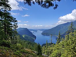
A southward view of Indian Arm, taken along the Dilly Dally Loop Trail in Indian Arm Provincial Park
|
|
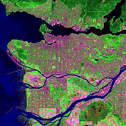
Satellite photo of the Vancouver region; Indian Arm is in the upper right corner.
|
|
| Location | North Shore Mountains Vancouver, British Columbia, Canada |
| Coordinates | 49°22′37″N 122°52′41″W / 49.37694°N 122.87806°W |
| Type | Fjord |
| Native name | Halkomelem: səl̓ilw̓ət |
| Part of | Burrard Inlet |
| Primary inflows | Indian River, Coquitlam River via Buntzen Power Plant |
| Max. length | 20 km (12 mi) |
| Max. width | 0.5 to 2 kilometres (0.31 to 1.24 mi) |
| Average depth | 120 metres (390 ft) |
| Max. depth | 218 metres (715 ft) |
| Islands | Twin Islands, Croker Island, Racoon Island |
| Settlements | North Vancouver Belcarra |
Indian Arm (also known as Halkomelem: səl̓ilw̓ət in the Halkomelem language) is a long, narrow arm of the sea. It's like a deep valley filled with ocean water, called a fjord. This fjord is right next to the city of Vancouver in British Columbia, Canada.
Indian Arm was formed during the last Ice Age. It stretches north from Burrard Inlet. On its sides are the communities of Belcarra to the east and the District of North Vancouver to the west. Further north, it becomes a wild, mountainous area. Explorers Captain George Vancouver and Dionisio Alcalá Galiano mapped and explored this area in June 1792.
Contents
Exploring Indian Arm's Geography
Indian Arm is a saltwater fjord that goes about 20 kilometers (12 miles) north from Burrard Inlet. There are no bridges or roads that cross it. Road access is only available to the towns at the southern part of the arm.
The mountains along Indian Arm are very steep and hard to travel through. Because of this, most of the area has not been developed, even though it's close to a big city. The Indian River is at the very north end of the arm. You can reach it by boat from Vancouver or by a logging road from Squamish.
What Can You See at Indian Arm?
The sides of Indian Arm are covered in thick forests or have tall, bare granite cliffs. The water is narrow, and the mountains rise steeply right out of the sea.
Waterfalls and Wildlife
You can find several waterfalls along Indian Arm. The biggest one is Granite Falls, located at the north end on the east side. Spray of Pearls Falls is in the northwest corner at Wigwam Creek. Silver Falls is on the western side at Elsay Creek.
Many other unnamed waterfalls appear during spring when the snow melts. In winter, you might even see frozen waterfalls. Granite Falls used to be a quarry where they dug out granite for buildings and sea walls in Vancouver.
You might spot different kinds of wildlife here. Look for seals, bald eagles, herons, and black bears. In odd-numbered years, from July to October, many pink salmon swim up the river. You can often see salmon and bears near the Indian River estuary in the northwest part of the inlet.
Parks and Outdoor Fun
Say Nuth Khaw Yum Provincial Park covers large parts of both sides of the fjord. It also includes Racoon and Twin Islands. This park is very big, covering about 6,826 hectares (16,867 acres).
There are places to camp by the sea at Bishop Creek (west side), Granite Falls, and Twin Islands. The park is popular for people who like boating and kayaking. You can also take boat tours from Granville Island, Port Moody, or Coal Harbour. Divers enjoy exploring the shallow waters around Racoon and Twin Islands.
The Say Nuth Khaw Yum Heritage Park / Indian Arm Provincial Park was created in 1995. This park is in the traditional territory of the Tsleil-Waututh First Nation. In 1998, the Tsleil-Waututh First Nation and the Government of BC agreed to manage the park together.
A rough hiking trail goes around the edge of Indian Arm. It was finished in 2003 by an engineer named Don McPherson, who also created the famous Grouse Grind trail.
The south-eastern part of Say Nuth Khaw Yum Provincial Park is next to the BC Hydro Buntzen Lake Recreation Area. təmtəmíxʷtən/Belcarra Regional Park is managed by Metro Vancouver Regional Parks. This park is around Bedwell Bay on the mid-western side of Indian Arm and includes the area around Sasamat Lake.
The Baden-Powell Trail is a challenging but well-kept hiking trail. It starts at Panorama Park in Deep Cove. It follows the slopes of the North Shore Mountains on the western side of Indian Arm, ending in Horseshoe Bay, West Vancouver.
Other parks near Indian Arm include Cates Park and Panorama Park in the District of North Vancouver, Barnet Marine Park in Burnaby, Rocky Point Park (which has a boat launch), Inlet Park and Tidal Park in Port Moody, and Thwaytes Landing Metro Park Reserve.
Other Places You Can Reach by Water
If you head north from Deep Cove, you will find Woodlands. This is a community with homes right on the beachfront.
As you go further north, you'll find other areas with cabins and beaches. These include Thwaites, Alder Point, Bergs, Croker Island, Indian River, Bedwell Bay, Belcarra, Anmore, Buntzen Bay, Jug Island, and Whiskey Cove. On the eastern shore, there's also the old, empty town of Iron Bay.
Buntzen Generating Station
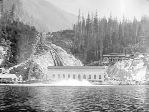
There are two old power plants on the eastern shore of Indian Arm. Water from Coquitlam Lake travels through a long tunnel to Buntzen Lake. This lake is about 150 meters (492 feet) above the water level of Indian Arm. Large pipes then carry the water from Buntzen Lake down to the two powerhouses on the shores of Indian Arm.
Buntzen No. 1 was built in 1903. It was made by the Vancouver City Light and Power Company to provide electricity for Vancouver's streetcars. It started with four generators. By 1912, three more powerful units were added. In 1950, part of the original building was taken down, and a new, larger generator was added in 1951.
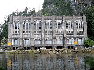
Buntzen No. 2 was designed by the English architect Francis Rattenbury. It was built in 1912, a short distance south of Buntzen No. 1. It produced a lot of power. One of its three water wheels was shut down in 1972.
Buntzen No. 1 was temporarily closed in 2010–2011 for an upgrade. Today, these power stations are controlled remotely by BC Hydro. In 2015, BC Hydro reported that the two powerhouses could produce 76.8 megawatts of electricity.
Buntzen No. 1 is to the north and has four buildings. Buntzen No. 2 is about 300 meters (1,000 feet) to the south. It is all contained within one beautiful building that has not changed much since 1912.
Wigwam Inn
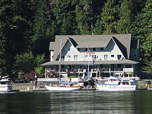
The Wigwam Inn is at the north end of Indian Arm. It first opened in 1910 as a fancy resort and fishing lodge. A daily steamship, the Skeena, brought guests and supplies to the inn. The inn was run by different people over the years. It even had some ups and downs, and at one point, it was used as a gambling place, which led to a visit from the police. Famous guests included rich people like oil tycoon John D. Rockefeller and the great-grandson of fur trade millionaire John Jacob Astor.
Today, the Royal Vancouver Yacht Club owns and runs the Wigwam Inn. It is a private spot for club members. There are no public docks for other boats. Some stories say that Al Capone once hid at the Wigwam, that crimes happened there, and that it might even be haunted!
 | Laphonza Butler |
 | Daisy Bates |
 | Elizabeth Piper Ensley |


