North Vancouver (district municipality) facts for kids
Quick facts for kids
North Vancouver
|
||
|---|---|---|
|
District municipality
|
||
| The Corporation of the District of North Vancouver | ||
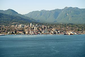
View of North Vancouver
|
||
|
||
| Nickname(s):
North Van
|
||
| Motto(s):
"Montes Rivique Nobis Inspirant"
(English: "The Mountains and Rivers Inspire Us") |
||
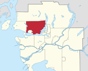
Location of the District of North Vancouver in Metro Vancouver
|
||
| Country | Canada | |
| Province | British Columbia | |
| Regional district | Metro Vancouver | |
| Incorporated | August 10, 1891 | |
| Government | ||
| • Type | Mayor-council government | |
| Area | ||
| • Land | 160.66 km2 (62.03 sq mi) | |
| Highest elevation | 1,449 m (4,754 ft) | |
| Lowest elevation | 0 m (0 ft) | |
| Population
(2021)
|
||
| • Total | 88,168 | |
| • Estimate
(2023)
|
95,350 | |
| • Density | 548.8/km2 (1,421/sq mi) | |
| Demonym(s) | North Vancouverite | |
| Time zone | UTC−08:00 (PST) | |
| • Summer (DST) | UTC−07:00 (PDT) | |
| Forward sortation area |
V7G – V7R
|
|
| Area codes | 604, 778, 236, 672 | |
The District of North Vancouver is a special kind of city area in British Columbia, Canada. It's located just north of the city of Vancouver, across the Burrard Inlet. This district completely surrounds the City of North Vancouver and borders West Vancouver. All three are part of the larger Metro Vancouver Regional District.
North Vancouver is known as a calm, well-off suburban area. Many middle and upper-middle-class families live here. You'll find homes ranging from family houses to very large luxury homes. Recently, more apartment buildings and mixed-use areas (with shops and homes) have been built. However, it's still mostly a suburban place. The area is kept safe by the Royal Canadian Mounted Police, the British Columbia Ambulance Service, and the local Fire Department.
Contents
History of North Vancouver
Early Indigenous Life and European Arrival
For thousands of years, the Indigenous Squamish and Tsleil-Waututh peoples lived in the area we now call North Vancouver. About 200 years ago, these First Nations people first saw Europeans. Spanish explorers arrived first, and then Captain George Vancouver explored the shores in 1792. But it wasn't until 1862 that people started to cut down the area's huge trees, which led to more people settling here.
Logging and Early Settlements
The first big business on the North Shore was Pioneer Mills, started in 1862. It was built to cut down the giant trees of the coastal rainforest. The mill changed owners a few times before Sewell ("Sue") Prescott Moody bought it in 1865. A town called Moodyville grew up near the mill. It was the main hub on the North Shore until the mill closed in 1901. Moodyville also had the first school. Another school, Central School, opened in 1902. Its building is still standing today as part of Presentation House, which is now home to the North Vancouver Museum and Archives.
Becoming a Municipality
In 1891, the first local government on the North Shore was created. It was called the District of North Vancouver. It covered a large area from Horseshoe Bay to Deep Cove, but it didn't include Moodyville at first. In the early 1900s, there was a big real estate boom. People like the British poet Rudyard Kipling bought land hoping to make money quickly.
A new community began to form. The Hotel North Vancouver was built in 1902. In 1905, the first bank opened. A local newspaper, the Express, started in 1905. By 1906, the British Columbia Electric Railway began running streetcar service.
Shipbuilding and Growth
Industry, especially shipbuilding, became very important. The many trees nearby provided lots of wood for building ships and houses. The Wallace Shipyards moved to the area in 1906 because electricity became available. This company, later known as Burrard Dry Dock, became a huge part of the local economy. Many of its old buildings are still there, even though the company is no longer operating.
Because the Lower Lonsdale area of North Vancouver was growing so fast, the separate City of North Vancouver was formed in 1907. It had about 1,500 people. West Vancouver also became its own separate municipality in 1912. The boundaries of the city haven't changed much since then, even though many more people live in the district today. Moodyville was added to the district in 1915.
Connecting with Vancouver
Getting to and from Vancouver has always been key for the North Shore. The first ferry service started in 1866 with "Navvy Jack’s" rowboat. In 1867, the Sea Foam began a regular ferry service that ran until 1958. The SeaBus brought back water transportation in 1977.
Train service took longer to develop. The Pacific Great Eastern Railway started a short train route from North Vancouver to Whytecliff Park in 1914. But it wasn't until the first Second Narrows Bridge was finished in 1925 that roads and trains connected the North Shore to the rest of the Lower Mainland.
Challenges and Revival
Early plans for North Vancouver were very big, but they faced many problems. A worldwide economic downturn in 1913 and then World War I stopped many projects. The Great Depression, which started in 1929, caused more economic trouble. Ships also kept hitting the Second Narrows Bridge, making travel difficult. Both the city and the district faced severe financial problems in 1933.
However, the opening of the Lions Gate Bridge in 1938 made the North Shore much easier to reach. And World War II brought an economic boost to North Vancouver. Many ships were built at the Burrard Dry Dock to help with Canada's war efforts.
After the war, both the city and the District of North Vancouver grew rapidly. Most of this growth happened in the district because it had more land available.
Since 2018, there have been talks about combining the District of North Vancouver with the City of North Vancouver into one single North Vancouver. Many residents support this idea, and some don't even realize they are currently separate places!
Geography of North Vancouver
The District of North Vancouver is separated from Vancouver by the Burrard Inlet. You can get there by crossing the Lions' Gate Bridge, the Ironworkers Memorial Second Narrows Crossing, or by taking the SeaBus passenger ferry.
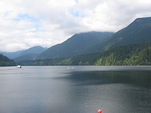
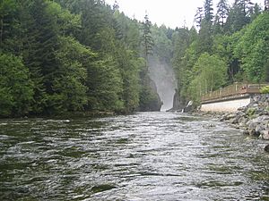
The district is surrounded by nature. The Capilano River is to the west, Indian Arm to the east, Burrard Inlet to the south, and the Coast Mountains to the north. It stretches from east to west along the mountain slopes. The area has rugged land with steep and winding roads. While there isn't one main city center, there are several separate shopping and community areas. These include (from west to east): Edgemont Village, Upper Lonsdale, Lynn Valley, Main Street, Parkgate, and Deep Cove.
The District of North Vancouver shares a lot in common with West Vancouver and the City of North Vancouver. Together, these three areas are often called the North Shore. Most people in the district live in single-family homes. Except for a few older areas, much of the district was built after the 1950s. The City of North Vancouver has more businesses and apartment buildings.
Climate in North Vancouver
North Vancouver has an oceanic climate. This means it has mild temperatures and rain throughout the year.
| Climate data for North Vancouver (N Vancouver 2nd Narrows) (Elevation: 4m) 1981–2010 | |||||||||||||
|---|---|---|---|---|---|---|---|---|---|---|---|---|---|
| Month | Jan | Feb | Mar | Apr | May | Jun | Jul | Aug | Sep | Oct | Nov | Dec | Year |
| Average precipitation mm (inches) | 262.2 (10.32) |
172.3 (6.78) |
168.4 (6.63) |
136.3 (5.37) |
103.3 (4.07) |
82.5 (3.25) |
53.2 (2.09) |
54.9 (2.16) |
76.8 (3.02) |
189.0 (7.44) |
293.4 (11.55) |
238.6 (9.39) |
1,830.8 (72.08) |
| Average rainfall mm (inches) | 255.3 (10.05) |
167.7 (6.60) |
166.8 (6.57) |
136.1 (5.36) |
103.3 (4.07) |
82.5 (3.25) |
53.2 (2.09) |
54.9 (2.16) |
76.8 (3.02) |
189.0 (7.44) |
290.2 (11.43) |
229.9 (9.05) |
1,805.6 (71.09) |
| Average snowfall cm (inches) | 6.9 (2.7) |
5.2 (2.0) |
1.6 (0.6) |
0.2 (0.1) |
0.0 (0.0) |
0.0 (0.0) |
0.0 (0.0) |
0.0 (0.0) |
0.0 (0.0) |
0.1 (0.0) |
2.3 (0.9) |
8.7 (3.4) |
24.9 (9.8) |
| Average precipitation days (≥ 0.2 mm) | 20.5 | 15.5 | 18.0 | 15.4 | 13.8 | 11.7 | 7.4 | 6.7 | 9.6 | 16.1 | 20.9 | 20.3 | 175.9 |
| Average rainy days (≥ 0.2 mm) | 19.7 | 15.1 | 17.9 | 15.4 | 13.8 | 11.7 | 7.4 | 6.7 | 9.6 | 16.0 | 20.7 | 19.6 | 173.5 |
| Average snowy days (≥ 0.2 cm) | 1.7 | 0.92 | 0.54 | 0.12 | 0.0 | 0.0 | 0.0 | 0.0 | 0.0 | 0.08 | 0.72 | 2.2 | 6.2 |
| Source: Environment Canada (normals, 1981–2010) | |||||||||||||
| Climate data for North Vancouver (N Vancouver Redonda Dr) (Elevation: 229m) 1971–2000 | |||||||||||||
|---|---|---|---|---|---|---|---|---|---|---|---|---|---|
| Month | Jan | Feb | Mar | Apr | May | Jun | Jul | Aug | Sep | Oct | Nov | Dec | Year |
| Average precipitation mm (inches) | 301.9 (11.89) |
285.3 (11.23) |
223.8 (8.81) |
187.0 (7.36) |
141.7 (5.58) |
108.3 (4.26) |
66.6 (2.62) |
81.3 (3.20) |
105.0 (4.13) |
232.0 (9.13) |
389.9 (15.35) |
353.9 (13.93) |
2,476.8 (97.51) |
| Average rainfall mm (inches) | 283.1 (11.15) |
263.9 (10.39) |
218.9 (8.62) |
186.0 (7.32) |
141.7 (5.58) |
108.3 (4.26) |
66.6 (2.62) |
81.3 (3.20) |
105.0 (4.13) |
231.7 (9.12) |
382.5 (15.06) |
331.6 (13.06) |
2,400.6 (94.51) |
| Average snowfall cm (inches) | 18.8 (7.4) |
21.5 (8.5) |
4.9 (1.9) |
1.1 (0.4) |
0.0 (0.0) |
0.0 (0.0) |
0.0 (0.0) |
0.0 (0.0) |
0.0 (0.0) |
0.3 (0.1) |
7.4 (2.9) |
22.3 (8.8) |
76.2 (30.0) |
| Average precipitation days (≥ 0.2 mm) | 19.1 | 17.8 | 17.4 | 16.2 | 14.8 | 12.1 | 7.4 | 7.1 | 10.0 | 15.5 | 20.0 | 20.7 | 177.9 |
| Average rainy days (≥ 0.2 mm) | 17.6 | 15.9 | 17.0 | 16.2 | 14.8 | 12.1 | 7.4 | 7.1 | 10.0 | 15.4 | 19.5 | 18.6 | 171.4 |
| Average snowy days (≥ 0.2 cm) | 3.9 | 3.5 | 1.6 | 0.45 | 0.0 | 0.0 | 0.0 | 0.0 | 0.0 | 0.10 | 1.9 | 4.5 | 15.8 |
| Source: Environment Canada (normals, 1971–2000) | |||||||||||||
Industry and Economy
For most of the 1900s, big industries like shipbuilding were the main drivers of North Vancouver's economy. Today, things have changed. Many companies in the North Shore now focus on creating and selling high technology.
The television and film industry is also very important here. North Vancouver is often called "Hollywood North." For example, the TV show The X-Files was filmed in North Vancouver for five seasons. Many of its "wilderness" scenes were shot in the Lower Seymour Conservation Reserve (LSCR).
Fun Places to Visit
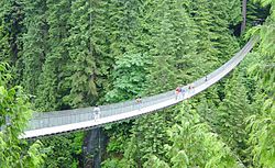
- The Capilano Suspension Bridge is in a private park. You can walk across this bridge high above the Capilano River. There are also nature trails and a special rainforest canopy walk. You need to pay an admission fee to enter.
- The Lynn Canyon Suspension Bridge is in a public park run by the District of North Vancouver. It's free to visit! The park also has the Lynn Canyon Ecology Centre.
- Grouse Mountain is a popular spot for skiing and tourists. You can reach the top by a gondola lift or by hiking the famous Grouse Grind trail.
- Mount Seymour Provincial Park is another great place for skiing and hiking in the district.
- The Cleveland Dam is located in the Capilano River Regional Park. Here you can find nature trails and a fish hatchery called the Capilano River Hatchery.
- Mount Fromme is a favorite place for mountain biking.
- Northlands Golf Course is a public golf course owned and operated by the District of North Vancouver.
- Maplewood Flats Conservation Area is a protected area perfect for bird watching. It has easy trails to explore.
- Maplewood Farm is a special children's farm run by the District of North Vancouver, where kids can learn about farm animals.
- The Museum of North Vancouver Archives is part of MONOVA. It keeps historical records about the North Shore.
Getting Around North Vancouver
The main highway that goes through the District of North Vancouver is the Trans-Canada Highway (Highway 1). This highway crosses from Vancouver over the Ironworkers Memorial Second Narrows Crossing. It then goes through the district to the border with West Vancouver.
Public transportation is provided by TransLink. Most of the bus routes are run by the Coast Mountain Bus Company. These buses travel throughout the North Shore and connect to other parts of Metro Vancouver, including the R2 Marine Dr route. The SeaBus ferry is also a key part of the transportation system. It stops at Lonsdale Quay, connecting the North Shore with Vancouver and the SkyTrain network at Waterfront station. West Vancouver Blue Bus also operates some routes in North Vancouver, including the 255, which links to West Vancouver.
Currently, North Vancouver doesn't have a rapid transit system like a SkyTrain. However, TransLink plans to build a bus rapid transit line. This line would go from Metrotown in Burnaby to Park Royal in West Vancouver. This project aims to help with traffic on the busy North Shore roads.
People and Population
In the 2021 Canadian census, North Vancouver had a population of 88,168 people. This was a slight increase from 85,649 people in 2016. The district covers an area of about 160.66 square kilometers.
Different Backgrounds
North Vancouver is home to people from many different backgrounds. Here's a look at the main groups living in the District of North Vancouver over the years:
| Panethnic group | 2021 | 2016 | 2011 | 2006 | 2001 | |||||
|---|---|---|---|---|---|---|---|---|---|---|
| Pop. | % | Pop. | % | Pop. | % | Pop. | % | Pop. | % | |
| European | 60,390 | 69.11% | 61,770 | 72.77% | 64,095 | 76.71% | 62,950 | 76.85% | 65,110 | 79.72% |
| East Asian | 8,975 | 10.27% | 8,720 | 10.27% | 7,555 | 9.04% | 8,260 | 10.08% | 7,450 | 9.12% |
| Middle Eastern | 7,900 | 9.04% | 5,705 | 6.72% | 4,680 | 5.6% | 3,755 | 4.58% | 3,505 | 4.29% |
| South Asian | 2,780 | 3.18% | 3,060 | 3.61% | 2,245 | 2.69% | 2,605 | 3.18% | 2,310 | 2.83% |
| Southeast Asian | 2,530 | 2.9% | 2,250 | 2.65% | 2,285 | 2.73% | 1,765 | 2.15% | 1,165 | 1.43% |
| Indigenous | 1,580 | 1.81% | 1,360 | 1.6% | 1,080 | 1.29% | 755 | 0.92% | 830 | 1.02% |
| Latin American | 1,255 | 1.44% | 780 | 0.92% | 790 | 0.95% | 740 | 0.9% | 660 | 0.81% |
| African | 475 | 0.54% | 470 | 0.55% | 235 | 0.28% | 455 | 0.56% | 295 | 0.36% |
| Other | 1,505 | 1.72% | 765 | 0.9% | 595 | 0.71% | 630 | 0.77% | 355 | 0.43% |
| Total responses | 87,385 | 99.11% | 84,880 | 98.77% | 83,555 | 98.98% | 81,910 | 99.21% | 81,675 | 99.23% |
| Total population | 88,168 | 100% | 85,935 | 100% | 84,412 | 100% | 82,562 | 100% | 82,310 | 100% |
- Note: The percentages can add up to more than 100% because some people reported more than one background.
Languages Spoken
Here are the main languages spoken at home by people in North Vancouver, according to the 2021 Canadian census:
| Mother tongue | Population | % of total population | % of non-official languages |
|---|---|---|---|
| English | 60,360 | 69.0% | N/A |
| Persian | 7,180 | 8.2% | 31.3% |
| Chinese languages | 4,020 | 4.6% | 17.5% |
| English and non-official language(s) | 2,110 | 2.4% | N/A |
| Korean | 1,530 | 1.7% | 6.7% |
| Spanish | 1,480 | 1.7% | 6.4% |
| French | 1,215 | 1.4% | N/A |
| German | 1,110 | 1.3% | 4.8% |
| Tagalog | 895 | 1.0% | 3.9% |
Among Chinese languages, 2.7% of the population speaks Mandarin, 1.7% speaks Cantonese, and 0.2% speak other types of Chinese.
Religious Beliefs
The 2021 census also gathered information on religious groups in North Vancouver:
- No religion (48,275 people or 55.2%)
- Christianity (29,845 people or 34.2%)
- Islam (5,570 people or 6.4%)
- Judaism (845 people or 1.0%)
- Buddhism (775 people or 0.9%)
- Sikhism (550 people or 0.6%)
- Hinduism (295 people or 0.3%)
- Indigenous spirituality (15 people or less than 0.1%)
Among Christians, 12.4% were Catholic, 11.4% were Protestant, and others belonged to various Christian groups.
See also
 In Spanish: Distrito de Vancouver Norte para niños
 | Delilah Pierce |
 | Gordon Parks |
 | Augusta Savage |
 | Charles Ethan Porter |


