
British Columbia Highway 1 facts for kids
Quick facts for kids
|
||||
|---|---|---|---|---|
| Trans-Canada Highway | ||||
|
A map of southern British Columbia with Hwy 1 highlighted in red
|
||||
| Route information | ||||
| Length | 1,047 km (651 mi) | |||
| Existed | 1961–present | |||
| Vancouver Island section | ||||
| Length | 116 km (72 mi) | |||
| South end | Dallas Road in Victoria | |||
| Major junctions |
||||
| North end | ||||
| Mainland section | ||||
| Length | 877 km (545 mi) | |||
| West end | ||||
| Major junctions |
|
|||
| East end | Alberta border at Kicking Horse Pass continues as |
|||
| Highway system | ||||
British Columbia provincial highways
|
||||
.svg)
British Columbia Highway 1 is a very important road in British Columbia, Canada. It is part of the famous Trans-Canada Highway, which crosses all of Canada. This highway stretches for about 1,039 kilometers (646 miles) across the southern part of BC. This includes parts where you need to take a ferry!
The highway begins near the border with Alberta, close to a place called Kicking Horse Pass. It goes through towns like Field. For some parts, between Monte Creek and Cache Creek, Highway 1 actually shares the road with Highway 5 and Highway 97.
The mainland part of Highway 1 ends in West Vancouver at the Horseshoe Bay ferry terminal. From there, you take a ferry to Vancouver Island. The highway then starts again on Vancouver Island near Departure Bay. It travels south along the island's eastern coast, finally ending in the city of Victoria.
| Top - 0-9 A B C D E F G H I J K L M N O P Q R S T U V W X Y Z |
Exploring Highway 1: A Journey Across BC
British Columbia Highway 1 is a long and exciting road. It connects many different parts of the province. It was officially established in 1961. This highway helps people travel for fun and for work.
The Mainland Adventure
The longest part of Highway 1 is on the mainland. It stretches for about 877 kilometers. This section starts at the Horseshoe Bay Ferry Terminal in West Vancouver. It then travels east across the province.
Along this part of the highway, you will pass through many cities and towns. These include Coquitlam, Surrey, Langley, and Abbotsford. You will also go through Hope, which is often called the "Gateway to the Fraser Canyon."
Sharing the Road
For a big part of its journey, Highway 1 shares its path with other highways. This is called a "concurrency." For example, between Monte Creek and Cache Creek, it travels alongside Highway 5 and Highway 97. This means you might see signs for all three highways at once!
Famous Bridges and Passes
As you travel east, you will cross some amazing bridges. One is the Port Mann Bridge over the Fraser River. It is a very long bridge. You will also go through mountain passes like Kicking Horse Pass. This pass is near the border with Alberta. It's a beautiful area with stunning views.


Vancouver Island Section
The Vancouver Island part of Highway 1 is about 116 kilometers long. It starts at the Departure Bay Ferry Terminal in Nanaimo. From there, it heads south.
This section of the highway follows the eastern coast of Vancouver Island. It offers beautiful views of the ocean and forests. The highway ends in Victoria, the capital city of British Columbia. In Victoria, you can find the "Mile Zero" monument. This marks the very beginning (or end) of the Trans-Canada Highway.


Images for kids
-
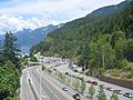
Ferry traffic on Highway 1 at the Horseshoe Bay Ferry Terminal.
-
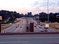
Highway 1 as it enters Vancouver from Burnaby.
-
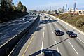
British Columbia Highway 1 near Brentwood, Burnaby.
-
Fraser Canyon along British Columbia Highway #1 between Hope and Yale
-
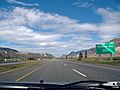
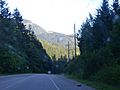
Highway 1 just east of Kamloops heading westbound.
-
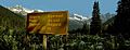
Summit of Rogers Pass
-
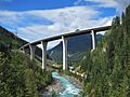
Highway 1 crossing the Park Bridge in the Kicking Horse Canyon


