
British Columbia Highway 97 facts for kids
Quick facts for kids
|
||||
|---|---|---|---|---|
| Okanagan Highway Cariboo Highway John Hart Highway Alaska Highway |
||||
| Lua error in Module:Infobox_road/map at line 15: attempt to index field 'wikibase' (a nil value). | ||||
| Route information | ||||
| Length | 2,081 km (1,293 mi) | |||
| Existed | 1953–present | |||
| Major junctions | ||||
| South end | ||||
| North end | ||||
| Location | ||||
| Districts: | Summerland, Peachland, Lake Country, 100 Mile House, Chetwynd, Taylor | |||
| Major cities: | Penticton, West Kelowna, Kelowna, Vernon, Kamloops, Williams Lake, Quesnel, Prince George, Dawson Creek, Fort St. John | |||
| Towns: | Osoyoos, Oliver, Cache Creek, Fort Nelson | |||
| Highway system | ||||
British Columbia provincial highways
|
||||

British Columbia Highway 97 is a very long road in British Columbia, Canada. It is a provincial highway, which means it is managed by the province. This highway stretches for an amazing 2,081 kilometers (that's about 1,293 miles!). It is a continuation of U.S. Route 97 from the United States, which is how it got its name.
This highway is super important for connecting many towns and cities. It helps people travel all the way from the Canada–United States border near Osoyoos in the south to the Yukon border in the north.
| Top - 0-9 A B C D E F G H I J K L M N O P Q R S T U V W X Y Z |
Many Names for One Highway
Highway 97 is so long that it has different names along its route. These names often come from the regions it passes through. It's like one road having many nicknames!
The Okanagan Highway
The first part of Highway 97, starting from the U.S. border, is called the "Okanagan Highway". This section is about 269 kilometers (167 miles) long. It goes through the beautiful Okanagan region. This area is famous for its lakes, orchards, and vineyards.
The Cariboo Highway
As you travel north, Highway 97 becomes the "Cariboo Highway". This part of the road connects towns like Cache Creek and Prince George. The Cariboo region is known for its history, especially from the gold rush days.
The John Hart Highway
North of Prince George, Highway 97 changes its name again to the "John Hart Highway". This section leads towards the Peace River Country. It is named after John Hart, a former Premier of British Columbia.
The Alaska Highway
The very northern part of Highway 97 is also known as the Alaska Highway. This famous road continues all the way into Alaska. It was built during World War II and is a very important route for northern travel.
Traveling Along Highway 97
Highway 97 passes through many different landscapes. You can see deserts, mountains, forests, and farmlands. It connects many important communities in British Columbia.
Major Cities and Towns
Some of the larger cities and towns you will find along Highway 97 include:
- Osoyoos, right at the U.S. border.
- Penticton, a city in the Okanagan Valley.
- Kelowna, a major city in the Okanagan.
- Vernon, another Okanagan city.
- Kamloops, where Highway 97 meets other major roads.
- Williams Lake, a hub in the Cariboo.
- Quesnel, another historic Cariboo town.
- Prince George, a large city in central B.C.
- Dawson Creek, the official start of the Alaska Highway.
- Fort St. John, a busy city in the Peace River region.
- Fort Nelson, a northern community.
Connecting Other Roads
Highway 97 connects with many other important roads. It meets up with other provincial highways like Highway 3, Highway 5, and Highway 16. These connections help people travel across British Columbia and beyond. For example, in Kamloops, Highway 97 shares a section with Highway 5. This is called a "concurrency" where two highways use the same road for a bit.
Images for kids
-
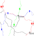
This diagram shows how Highways 5 and 97 share a road through Kamloops.
-
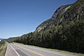
A view of B.C. Highway 97 (Alaska Highway) near Stone Mountain Provincial Park.


