
Fort Nelson, British Columbia facts for kids
Quick facts for kids
Fort Nelson
|
|
|---|---|
| Nicknames:
Mile 300, Fort Nelly, F-N
|
|

Fort Nelson
Location in British Columbia

Fort Nelson
Location in Canada
|
|
| Country | Canada |
| Province | British Columbia |
| Regional Municipality | Northern Rockies |
| Incorporated | 1971 |
| Amalgamated | 2009 |
| Area
(2016)
|
|
| • Total | 4.68 km2 (1.81 sq mi) |
| Elevation | 410 m (1,350 ft) |
| Population
(2016)
|
|
| • Total | 3,366 |
| • Density | 719.1/km2 (1,862/sq mi) |
| Time zone | UTC−07:00 (MST) |
| Postal code span |
V0C
|
| Area code(s) | 250 / 778 / 236 |
| Highways | |
| Website | |
Fort Nelson is a town in northeast British Columbia, Canada. It is part of the Northern Rockies Regional Municipality (NRRM). Fort Nelson used to be a town on its own. But in 2009, it joined with the larger Northern Rockies Regional District. This made it the first regional municipality in British Columbia. Fort Nelson is now the main office for the NRRM.
The town is located east of the northern Rocky Mountains. It is in the Peace River region, right along the Alaska Highway at "Mile 300." Fort Nelson is about a four-hour drive from Fort St. John, which is the closest big town. In winter, this drive can take up to six hours. The Alaska Highway is usually well-cleared in winter and offers amazing views all year.
In 2016, the population of Fort Nelson was 3,366 people. This was a small decrease from the 2011 count.
Contents
Fort Nelson's History
Fort Nelson was named after a famous British naval hero, Horatio Nelson, 1st Viscount Nelson. It started in 1805 as a fur-trading post. The North West Trading Company set it up. Over time, due to fires, floods, and other problems, Fort Nelson has moved five times!
How World War II Shaped Fort Nelson
The Fort Nelson Airport was very important during World War II. It was an airbase for both the United States Air Force and the Royal Canadian Air Force. Many people think the Alaska Highway started in Dawson Creek. But Fort Nelson was actually the original "Mile 0" of the highway. This is because a road already existed from Fort St. John to Fort Nelson.
The United States Army built the Alaska Highway in 1942. They believed that Alaska was in danger of a Japanese invasion. More than 11,000 U.S. soldiers worked on building the highway. It was finished in about nine months. This made Fort Nelson a busy place for services along the road. After Japan surrendered in 1945, the U.S. Army gave the Canadian part of the highway to the Canadian government. It was opened to the public in 1948.
Fort Nelson After World War II
In the early 1950s, land was sold to local people. This was the start of Fort Nelson as a separate community, not just a military base. Oil and gas exploration began around the same time. This industry helped Fort Nelson grow a lot. It became a village in 1971.
Later, BC Hydro built a natural gas power plant. This brought electricity to the area and helped Fort Nelson grow even more. In 1971, the Pacific Great Eastern Railway built a railway to Fort Nelson. This made it easier to transport local products like lumber and gas to bigger markets. However, the railway was later closed due to lack of use.
Recent Times in Fort Nelson
Fort Nelson held its first Northern Lights Festival in March 2019. Many visitors came to experience life in northern British Columbia. The festival included dog sled races, trips to Liard Hot Springs, and viewing the northern lights. There were also Indigenous cultural events and concerts.
In 2008, both major forestry mills in Fort Nelson closed. This was a big blow to the town's economy. Then, in 2014, oil prices dropped. This greatly affected the natural gas industry. Many companies closed their local operations. This led to many job losses.
On May 10, 2024, everyone in Fort Nelson had to leave their homes. This was because of a large wildfire near Parker Lake. Residents were allowed to return on May 27. Because of the fire and gas supply issues, a natural gas plant also closed. This meant more job losses for the community.
Fort Nelson's Geography
Fort Nelson is located where three rivers meet: the Fort Nelson River, Muskwa River, and Prophet River. The whole Northern Rockies Regional Municipality is huge, making up 10% of British Columbia's land. Fort Nelson is known for being surrounded by the beautiful northern Rocky Mountains.

Wildlife in the Northern Rockies
The Northern Rockies Regional Municipality is home to many different animals. This attracts lots of tourists and hunters. You can find animals like moose, black bears, grizzly bears, caribou, and deer. There are also elk, bison, stone sheep, mountain goats, and wolves.
The area around Liard Hot Springs is also home to many bird species. These include the golden eagle, the bald eagle, and the great horned owl.

Fort Nelson's Climate
Fort Nelson has a climate that is a mix of two types: a humid continental climate and a subarctic climate. Winters are usually very cold and dry. Summers are warm, but very hot days are rare. It's interesting that even though it gets very cold, every month of the year has seen temperatures above 10 degrees Celsius.
Fort Nelson is colder than other places in British Columbia from November to February. But in the summer, its average temperature is warmer than coastal cities like Victoria and similar to Vancouver.
| Climate data for Fort Nelson (Fort Nelson Airport) WMO ID: 71945; coordinates 58°50′11″N 122°35′50″W / 58.83639°N 122.59722°W; elevation: 381.9 m (1,253 ft); 1991–2020 normals |
|||||||||||||
|---|---|---|---|---|---|---|---|---|---|---|---|---|---|
| Month | Jan | Feb | Mar | Apr | May | Jun | Jul | Aug | Sep | Oct | Nov | Dec | Year |
| Record high humidex | 9.0 | 13.3 | 16.1 | 26.7 | 33.9 | 36.4 | 41.2 | 36.6 | 32.3 | 26.7 | 17.8 | 10.4 | 41.2 |
| Record high °C (°F) | 11.6 (52.9) |
15.0 (59.0) |
17.8 (64.0) |
27.3 (81.1) |
32.1 (89.8) |
34.6 (94.3) |
36.7 (98.1) |
34.4 (93.9) |
32.8 (91.0) |
26.7 (80.1) |
18.3 (64.9) |
10.7 (51.3) |
36.7 (98.1) |
| Mean daily maximum °C (°F) | −16.1 (3.0) |
−8.7 (16.3) |
−1.3 (29.7) |
9.6 (49.3) |
17.1 (62.8) |
21.5 (70.7) |
23.3 (73.9) |
21.6 (70.9) |
15.4 (59.7) |
5.7 (42.3) |
−7.9 (17.8) |
−14.4 (6.1) |
5.5 (41.9) |
| Daily mean °C (°F) | −20.3 (−4.5) |
−14.4 (6.1) |
−8.0 (17.6) |
3.0 (37.4) |
10.2 (50.4) |
15.2 (59.4) |
17.3 (63.1) |
15.3 (59.5) |
9.4 (48.9) |
1.0 (33.8) |
−11.9 (10.6) |
−18.3 (−0.9) |
−0.1 (31.8) |
| Mean daily minimum °C (°F) | −24.4 (−11.9) |
−20.1 (−4.2) |
−14.6 (5.7) |
−3.6 (25.5) |
3.3 (37.9) |
8.8 (47.8) |
11.0 (51.8) |
9.0 (48.2) |
3.3 (37.9) |
−3.7 (25.3) |
−15.8 (3.6) |
−22.2 (−8.0) |
−5.8 (21.6) |
| Record low °C (°F) | −51.7 (−61.1) |
−48.3 (−54.9) |
−39.4 (−38.9) |
−34.4 (−29.9) |
−15.0 (5.0) |
−1.5 (29.3) |
1.1 (34.0) |
−4.5 (23.9) |
−16.7 (1.9) |
−28.6 (−19.5) |
−41.1 (−42.0) |
−47.8 (−54.0) |
−51.7 (−61.1) |
| Record low wind chill | −55.0 | −55.6 | −51.5 | −37.6 | −19.9 | −3.3 | 0.0 | −3.8 | −19.7 | −39.2 | −51.6 | −54.6 | −55.6 |
| Average precipitation mm (inches) | 21.5 (0.85) |
14.9 (0.59) |
18.8 (0.74) |
18.9 (0.74) |
49.0 (1.93) |
63.0 (2.48) |
78.4 (3.09) |
71.3 (2.81) |
40.2 (1.58) |
32.6 (1.28) |
25.6 (1.01) |
18.0 (0.71) |
452.1 (17.80) |
| Average rainfall mm (inches) | 0.3 (0.01) |
0.1 (0.00) |
0.3 (0.01) |
7.4 (0.29) |
42.4 (1.67) |
62.9 (2.48) |
78.4 (3.09) |
70.7 (2.78) |
37.4 (1.47) |
12.1 (0.48) |
0.7 (0.03) |
0.2 (0.01) |
312.6 (12.31) |
| Average snowfall cm (inches) | 28.6 (11.3) |
22.4 (8.8) |
27.2 (10.7) |
15.7 (6.2) |
7.5 (3.0) |
0.1 (0.0) |
0.0 (0.0) |
0.6 (0.2) |
3.4 (1.3) |
23.3 (9.2) |
35.3 (13.9) |
26.8 (10.6) |
190.8 (75.1) |
| Average precipitation days (≥ 0.2 mm) | 10.5 | 8.7 | 8.9 | 6.4 | 10.3 | 12.9 | 14.6 | 12.7 | 10.7 | 10.3 | 11.1 | 9.8 | 126.9 |
| Average rainy days (≥ 0.2 mm) | 0.3 | 0.1 | 0.4 | 2.8 | 9.5 | 12.9 | 14.6 | 12.7 | 10.1 | 5.0 | 0.5 | 0.3 | 69.2 |
| Average snowy days (≥ 0.2 cm) | 11.2 | 9.5 | 9.3 | 4.4 | 1.9 | 0.0 | 0.0 | 0.2 | 1.2 | 6.8 | 11.8 | 10.6 | 66.7 |
| Average relative humidity (%) | 71.3 | 63.6 | 50.8 | 41.3 | 42.0 | 45.2 | 50.5 | 51.6 | 53.8 | 66.3 | 77.9 | 75.2 | 57.5 |
| Mean monthly sunshine hours | 64.3 | 99.4 | 166.3 | 236.4 | 267.3 | 285.2 | 273.7 | 258.2 | 170.6 | 97.6 | 60.4 | 48.3 | 2,027.7 |
| Percent possible sunshine | 29.3 | 38.1 | 45.5 | 54.7 | 51.2 | 51.9 | 50.0 | 53.9 | 44.1 | 30.6 | 25.7 | 24.4 | 41.6 |
| Source 1: Environment and Climate Change Canada | |||||||||||||
| Source 2: Environment and Climate Change Canada | |||||||||||||
| Climate data for Fort Nelson (Fort Nelson Airport); coordinates 58°50′11″N 122°35′50″W; elevation: 381.9 m (1,253 ft); 1991–2020 normals; extremes 1937-present | |||||||||||||
|---|---|---|---|---|---|---|---|---|---|---|---|---|---|
| Month | Jan | Feb | Mar | Apr | May | Jun | Jul | Aug | Sep | Oct | Nov | Dec | Year |
| Record high humidex | 9.0 | 13.3 | 16.1 | 26.7 | 33.9 | 36.4 | 41.2 | 36.6 | 32.3 | 26.7 | 17.8 | 10.4 | 41.2 |
| Record high °C (°F) | 10.7 (51.3) |
15.0 (59.0) |
17.8 (64.0) |
27.3 (81.1) |
32.1 (89.8) |
33.9 (93.0) |
36.7 (98.1) |
34.4 (93.9) |
32.8 (91.0) |
26.7 (80.1) |
18.3 (64.9) |
10.7 (51.3) |
36.7 (98.1) |
| Mean daily maximum °C (°F) | −16.1 (3.0) |
−8.7 (16.3) |
−1.3 (29.7) |
9.6 (49.3) |
17.1 (62.8) |
21.5 (70.7) |
23.3 (73.9) |
21.6 (70.9) |
15.4 (59.7) |
5.7 (42.3) |
−7.9 (17.8) |
−14.4 (6.1) |
5.5 (41.9) |
| Daily mean °C (°F) | −20.3 (−4.5) |
−14.4 (6.1) |
−8.0 (17.6) |
3.0 (37.4) |
10.2 (50.4) |
15.2 (59.4) |
17.3 (63.1) |
15.3 (59.5) |
9.4 (48.9) |
1.0 (33.8) |
−11.9 (10.6) |
−18.3 (−0.9) |
−0.1 (31.8) |
| Mean daily minimum °C (°F) | −24.4 (−11.9) |
−20.1 (−4.2) |
−14.6 (5.7) |
−3.6 (25.5) |
3.3 (37.9) |
8.8 (47.8) |
11.1 (52.0) |
9.0 (48.2) |
3.3 (37.9) |
−3.7 (25.3) |
−15.8 (3.6) |
−22.2 (−8.0) |
−5.7 (21.7) |
| Record low °C (°F) | −51.7 (−61.1) |
−48.3 (−54.9) |
−39.4 (−38.9) |
−34.4 (−29.9) |
−15.0 (5.0) |
−1.1 (30.0) |
1.1 (34.0) |
−4.5 (23.9) |
−16.7 (1.9) |
−28.6 (−19.5) |
−41.1 (−42.0) |
−47.8 (−54.0) |
−51.7 (−61.1) |
| Record low wind chill | −55.0 | −55.6 | −51.5 | −37.6 | −19.9 | −3.3 | 0.0 | −3.8 | −19.7 | −39.2 | −51.6 | −54.6 | −55.6 |
| Average precipitation mm (inches) | 23.5 (0.93) |
16.2 (0.64) |
22.3 (0.88) |
15.9 (0.63) |
44.3 (1.74) |
75.2 (2.96) |
81.1 (3.19) |
70.2 (2.76) |
38.1 (1.50) |
24.3 (0.96) |
28.9 (1.14) |
18.4 (0.72) |
458.4 (18.05) |
| Average precipitation days (≥ 0.2 mm) | 10.7 | 8.5 | 9.6 | 6.4 | 9.7 | 13.5 | 14.2 | 12.6 | 10.6 | 9.8 | 11.9 | 10.2 | 127.7 |
| Mean monthly sunshine hours | 64.3 | 99.4 | 166.3 | 236.4 | 267.3 | 285.2 | 273.7 | 258.2 | 170.6 | 97.6 | 60.4 | 48.3 | 2,027.7 |
| Percent possible sunshine | 29.3 | 38.1 | 45.5 | 54.7 | 51.2 | 51.9 | 50.0 | 53.9 | 44.1 | 30.6 | 25.7 | 24.4 | 41.6 |
| Source: Environment Canada | |||||||||||||
Fort Nelson's Population
In 2016, Fort Nelson had 3,336 residents. This means about 69% of the total population of the Northern Rockies Regional Municipality lives in Fort Nelson.
Fort Nelson is a younger community compared to the rest of British Columbia. About 26.68% of the people are under 19 years old. Also, about 31.92% of adults over 25 have gone to college or trade school.
| Historical populations | ||
|---|---|---|
| Year | Pop. | ±% |
| 2001 | 4,188 | — |
| 2006 | 4,514 | +7.8% |
| 2011 | 3,902 | −13.6% |
| 2016 | 3,366 | −13.7% |
Fort Nelson's Economy
Fort Nelson's economy has changed a lot. After 2014, the price of oil dropped a lot. This made it harder to use the large amounts of natural gas in the area. Many businesses closed, and fewer people enrolled in schools.
Before 2014, natural gas, forestry, tourism, and agriculture were the main industries. Today, the town mostly depends on the government sector and tourism.
In March 2021, the Fort Nelson First Nation received money to develop a geothermal project. This project uses heat from the Earth to create energy. People hope it will bring new jobs and growth to the area.
Natural Gas Industry
The natural gas industry used to be the biggest employer in Fort Nelson. The region has huge amounts of gas in shale rock formations. Many big oil and gas companies used to operate here.
Gas is often extracted using horizontal drilling and hydraulic fracturing (fracking). This involves drilling deep into the ground. There are always discussions about how this industry affects the environment and local communities.
In 2020, a company called NorthRiver Midstream bought the biggest private employer in town. Soon after, they announced the complete shutdown of the gas plant. This caused many people to lose their jobs.
Forestry Industry

Fort Nelson is surrounded by huge boreal forests. This large supply of timber attracted companies like Canfor to build big factories. These factories employed hundreds of people.
However, in recent years, both the Canfor mill and the Tackama mill have closed. This was due to high costs and problems in the housing market. The mill closures were very hard for local families. Now, the local government is the largest employer.
Tourism Industry
Tourism is a very important part of Fort Nelson's economy, even though it's mostly seasonal. About 300,000 tourists visit Fort Nelson each year. Most of them are retired travelers in RVs going to or from Alaska.
The Northern Rockies Regional Municipality has several famous tourist spots. These include the Liard River Hot Springs Provincial Park, Muncho Lake Provincial Park, and the Alaska Highway. Many people enjoy Hunting, fishing, snowmobiling, dog sledding, birdwatching, and hiking in the area.
Fun Things to Do in Fort Nelson

- In Fort Nelson:
- Fort Nelson Heritage Museum: Learn about the area's past.
- Poplar Hills Golf Club: Play a round of golf.
- The Phoenix Theatre: Catch a movie.
- Northern Rockies Recreation Centre: A great place for sports and activities.
- Fort Nelson Community Literacy Society's October Culture Fest: Enjoy local culture.
- The Northern Lights Festival:
- Canadian Open Dog Sled Races: Watch exciting dog sledding.
- Dene Handgames: Experience traditional Indigenous games.
- Northern Lights Trappers Rendezvous: Learn about trapping history.
- Trade Show (May): See local businesses and products.
- Canoeing down the Fort Nelson River: Explore the river by canoe.
- In the Northern Rockies:
- Liard Hot Springs: Relax in natural hot springs.
- Northern Rocky Mountains Provincial Park: Enjoy the beautiful mountains.
- Smith River Falls – Fort Halkett Provincial Park: See amazing waterfalls.
- Wokkpash Lake and the Wokkpash Recreation Area: Explore wilderness.
- Muncho Lake: See the lake's unique blue-green color.
- Rafting on the Liard River: Go on a river adventure.
In 2005, Fort Nelson set a world record! People had a water balloon fight with over 40,000 water balloons thrown in less than three minutes.
Fort Nelson's Transportation
Roads in and Around Fort Nelson
Fort Nelson is located on Highway 97, also known as the Alaska Highway. It's south of where it meets the Liard Highway (British Columbia Highway 77).
The Sierra Yoyo Desan Road is a main road for oilfields in the area. It starts in Fort Nelson and goes about 188 km northeast. There are also many other resource roads and winter ice roads that connect to Alberta.
In 2018, Greyhound Canada stopped its bus service to Fort Nelson. This made it harder for residents to travel, especially for medical appointments. Now, BC Bus North offers bus service only once a week.
Fort Nelson Airport
The Fort Nelson Airport is also called the Northern Rockies Regional Airport (NRRA). It is located about 3.8 nautical miles east-northeast of Fort Nelson. It is a regional airport in Canada.
Currently, only one airline, Central Mountain Air, flies to the airport. They have reduced their service to only one flight per day, six days a week. Passengers can connect to other places through the Prince George Airport. The Fort Nelson Airport does not have passenger screening like bigger airports.
Rail Service
CN Rail operates a train line that ends in Fort Nelson. This line used to be part of BC Rail. CN currently brings fuel to the area twice a week.
Education in Fort Nelson
Fort Nelson has several schools. There are three public elementary schools: G.W. Carlson (Kindergarten to Grade 4), J.S. Clark (Kindergarten to Grade 4), and R.L. Angus (Grades 5 to 7). There is also one public high school, Fort Nelson Secondary School (Grades 8 to 12).
The Fort Nelson First Nation also runs its own independent school called Chalo School. In addition, Northern Lights College has a small campus in Fort Nelson. Students can earn trade certificates and diplomas there.
The number of students in School District 81 Fort Nelson has decreased a lot. This is because the town's population has gone down.
Images for kids
-
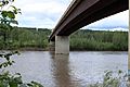
Muskwa River
-
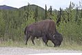
Bison in Northern Rockies
-
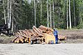
Fort Nelson Forestry
-
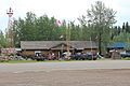
Fort Nelson Heritage Museum located on the Alaska Highway
See also
 In Spanish: Fort Nelson (Columbia Británica) para niños
