Fort St. John, British Columbia facts for kids
Quick facts for kids
Fort St. John
|
|||
|---|---|---|---|
| City of Fort St. John | |||
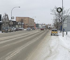
Downtown Fort St. John
|
|||
|
|||
| Nickname(s):
FSJ
|
|||
| Motto(s):
The Energetic City
|
|||
| Country | Canada | ||
| Province | British Columbia | ||
| Regional District | Peace River | ||
| Incorporated | 31 Dec 1947 (village) | ||
| Area | |||
| • City | 22.69 km2 (8.76 sq mi) | ||
| • Metro | 620.80 km2 (239.69 sq mi) | ||
| Elevation | 690 m (2,260 ft) | ||
| Population
(2020)
|
|||
| • City | 22,283 | ||
| • Density | 820.2/km2 (2,124/sq mi) | ||
| • Metro | 28,396 | ||
| • Metro density | 42.5/km2 (110/sq mi) | ||
| Time zone | UTC−07:00 (MST) | ||
| Forward sortation area |
V1J
|
||
| Area code(s) | 250, 778, 236, 672 | ||
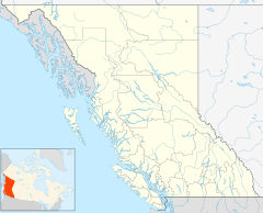
Fort St. John is a city in northeastern British Columbia, Canada. It's the biggest city in the Peace River Regional District. The city covers about 22 square kilometers and had 21,465 people in 2021. Fort St. John is located at Mile 47 of the Alaska Highway. It is one of the largest cities between Dawson Creek, British Columbia and Delta Junction, Alaska.
Fort St. John started in 1794 as a trading post. This makes it the oldest European settlement in British Columbia. The city has its own airport, the Fort St. John Airport. Its slogan is Fort St. John: The Energetic City.
Contents
History of Fort St. John
Over the years, Fort St. John has moved six times! The first trading post here was called Rocky Mountain House. It was built in 1794, a year after Sir Alexander Mackenzie explored the area. This fort was one of many along the Peace River. They were used for the fur trade, where people exchanged goods for animal furs.
First Nations groups like the Dane-zaa and Sikanni used it for trading. It also helped supply explorers going further into the land. This first fort closed in 1805. Another fort, Fort d'Epinette, was built in 1806. It was renamed Fort St. John in 1821 when the Hudson's Bay Company bought the North West Company. This fort closed in 1823. Today, this old site is a National Historic Site of Canada.
After almost 40 years, Fort St. John reopened in 1860. It was on the south side of the Peace River. In 1872, it moved again, directly across the river. This community lasted until 1925. By then, the river was no longer the main way to travel. So, the fort moved closer to where settlers were building farms.
The new town was built at Fish Creek. This was northwest of the current city. It stayed there until 1975. In 1928, C. M. Finch moved his store to the current city site. He also built a government building there. The city grew from there after he gave land for a church and a hospital.
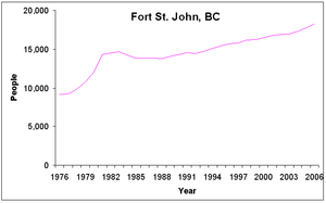
The first time Fort St. John was counted as a city was in 1951. It had 884 people then. The population grew very fast, almost doubling every five years for 15 years. By 1966, there were 6,749 people living here.
Geography of Fort St. John
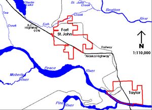
Fort St. John is on the western edge of the Canadian prairies. These flat lands cover much of Alberta, Saskatchewan, and Manitoba. The city sits between the Peace River and Beatton River. Charlie Lake is also nearby.
The city is about 690 meters above sea level. It is in a low valley near the eastern hills of the Northern Rockies. To the east and north are prairies. To the west, the Rocky Mountains block some of the rain. The city itself is built on gentle, rolling hills.
Fort St. John is part of the Peace River Country. This is a large area in British Columbia and Alberta. The Peace River valley is great for farming. You can grow crops like wheat and canola here. This is different from the rugged mountains to the west.
Climate in Fort St. John
Fort St. John has a cold climate with warm summers. Winters can be very cold. But they are milder than in many other parts of Canada. This is because the Rocky Mountains block cold air from the north. Winds mostly blow from the southwest.
Because it's far north, Fort St. John has short daylight hours in winter. But in summer, the days are very long! The city uses Mountain Standard Time all year.
Fort St. John is one of the sunniest places in British Columbia. Especially in winter and spring. It holds records for the most sunshine in March, May, and November.
The hottest temperature ever recorded was 38.3°C on July 16, 1941. The coldest was -53.9°C on January 11, 1911.
| Climate data for Fort St. John (Fort St. John Airport) WMO ID: 71943; coordinates 56°14′17″N 120°44′25″W / 56.23806°N 120.74028°W; elevation: 694.9 m (2,280 ft); 1991-2020 normals (sun 1981–2010), extremes 1910–present |
|||||||||||||
|---|---|---|---|---|---|---|---|---|---|---|---|---|---|
| Month | Jan | Feb | Mar | Apr | May | Jun | Jul | Aug | Sep | Oct | Nov | Dec | Year |
| Record high humidex | 12.7 | 12.4 | 17.3 | 28.5 | 31.5 | 34.3 | 37.4 | 34.5 | 32.6 | 25.4 | 16.2 | 11.2 | 37.4 |
| Record high °C (°F) | 12.9 (55.2) |
12.8 (55.0) |
19.7 (67.5) |
27.9 (82.2) |
31.8 (89.2) |
38.1 (100.6) |
38.3 (100.9) |
33.6 (92.5) |
30.0 (86.0) |
25.8 (78.4) |
18.3 (64.9) |
11.4 (52.5) |
38.3 (100.9) |
| Mean daily maximum °C (°F) | −8.6 (16.5) |
−5.4 (22.3) |
−0.5 (31.1) |
9.1 (48.4) |
16.0 (60.8) |
19.7 (67.5) |
21.7 (71.1) |
20.8 (69.4) |
15.7 (60.3) |
7.7 (45.9) |
−2.4 (27.7) |
−6.9 (19.6) |
7.2 (45.0) |
| Daily mean °C (°F) | −12.7 (9.1) |
−9.7 (14.5) |
−5.2 (22.6) |
3.8 (38.8) |
10.1 (50.2) |
14.2 (57.6) |
16.3 (61.3) |
15.0 (59.0) |
10.4 (50.7) |
3.5 (38.3) |
−6.1 (21.0) |
−10.8 (12.6) |
2.4 (36.3) |
| Mean daily minimum °C (°F) | −16.7 (1.9) |
−14.0 (6.8) |
−9.8 (14.4) |
−1.5 (29.3) |
4.2 (39.6) |
8.70 (47.66) |
10.70 (51.26) |
9.3 (48.7) |
5.1 (41.2) |
−0.7 (30.7) |
−9.7 (14.5) |
−14.6 (5.7) |
−2.4 (27.7) |
| Record low °C (°F) | −53.9 (−65.0) |
−42.2 (−44.0) |
−36.7 (−34.1) |
−28.9 (−20.0) |
−13.1 (8.4) |
−1.0 (30.2) |
0.7 (33.3) |
−2.9 (26.8) |
−12.8 (9.0) |
−25.0 (−13.0) |
−39.2 (−38.6) |
−44.6 (−48.3) |
−53.9 (−65.0) |
| Record low wind chill | −59.5 | −59.3 | −48.7 | −37.8 | −19.9 | −6.2 | 0.0 | −7.8 | −18.4 | −35.3 | −58.3 | −53.9 | −59.5 |
| Average precipitation mm (inches) | 28.4 (1.12) |
20.7 (0.81) |
26.6 (1.05) |
20.6 (0.81) |
34.1 (1.34) |
74.9 (2.95) |
76.5 (3.01) |
47.8 (1.88) |
42.3 (1.67) |
33.4 (1.31) |
34.7 (1.37) |
23.6 (0.93) |
463.6 (18.25) |
| Average rainfall mm (inches) | 0.7 (0.03) |
0.6 (0.02) |
0.8 (0.03) |
8.7 (0.34) |
27.6 (1.09) |
74.6 (2.94) |
76.5 (3.01) |
47.8 (1.88) |
37.6 (1.48) |
12.8 (0.50) |
4.2 (0.17) |
0.4 (0.02) |
292.3 (11.51) |
| Average snowfall cm (inches) | 34.4 (13.5) |
26.3 (10.4) |
30.0 (11.8) |
14.5 (5.7) |
6.8 (2.7) |
0.3 (0.1) |
0.0 (0.0) |
0.0 (0.0) |
4.9 (1.9) |
22.2 (8.7) |
37.6 (14.8) |
29.0 (11.4) |
205.9 (81.1) |
| Average precipitation days (≥ 0.2 mm) | 11.8 | 8.4 | 9.3 | 6.7 | 8.9 | 12.3 | 12.5 | 10.3 | 10.0 | 9.5 | 11.5 | 9.1 | 120.3 |
| Average rainy days (≥ 0.2 mm) | 0.92 | 0.5 | 0.75 | 3.8 | 7.9 | 12.3 | 12.5 | 10.3 | 9.7 | 5.0 | 2.6 | 0.43 | 66.6 |
| Average snowy days (≥ 0.2 cm) | 11.7 | 8.7 | 8.8 | 3.7 | 1.7 | 0.0 | 0.0 | 0.0 | 0.8 | 5.6 | 10.3 | 9.2 | 60.4 |
| Average relative humidity (%) (at 15:00 LST) | 69.0 | 62.8 | 54.2 | 42.9 | 39.9 | 47.1 | 49.7 | 49.3 | 51.3 | 58.5 | 72.1 | 71.9 | 55.7 |
| Mean monthly sunshine hours | 74.3 | 106.4 | 175.0 | 223.4 | 267.7 | 266.5 | 287.4 | 260.0 | 177.7 | 134.7 | 70.5 | 51.8 | 2,095.4 |
| Percent possible sunshine | 31.5 | 39.4 | 47.8 | 52.5 | 52.9 | 50.6 | 54.5 | 55.5 | 46.3 | 41.6 | 28.4 | 23.8 | 43.7 |
| Source: Environment and Climate Change Canada (sun) (January minimum) (March maximum) (April maximum) (June maximum) (July maximum) | |||||||||||||
People in Fort St. John (Demographics)
| Historical populations | ||
|---|---|---|
| Year | Pop. | ±% |
| 2001 | 16,051 | — |
| 2006 | 17,402 | +8.4% |
| 2011 | 18,609 | +6.9% |
| 2016 | 20,155 | +8.3% |
In the 2021 Census, Fort St. John had 21,465 people. They lived in 8,777 homes. This was a small increase from 2016. The city's land area is about 32.67 square kilometers.
Here's a look at the population in 2001:
| Fort St. John | British Columbia | |
|---|---|---|
| Median age | 32.0 years | 38.4 years |
| Under 15 years old | 22.1% | 18% |
| Between 25 and 44 years old | 33.4% | 30% |
| Over 65 years old | 6.7% | 14% |
| Visible minority | 3% | 21% |
| Protestant | 38% | 31% |
Different Backgrounds (Ethnicity)
Fort St. John is home to people from many different backgrounds. The table below shows the main groups living in the city over the years.
| Panethnic group |
2021 | 2016 | 2011 | 2006 | 2001 | 1996 | ||||||||
|---|---|---|---|---|---|---|---|---|---|---|---|---|---|---|
| Pop. | % | Pop. | % | Pop. | % | Pop. | % | Pop. | % | Pop. | % | |||
| European | 14,970 | 70.7% | 15,195 | 76.7% | 15,395 | 83.44% | 14,990 | 86.65% | 13,695 | 85.94% | 13,405 | 89.85% | ||
| Indigenous | 2,770 | 13.08% | 2,240 | 11.31% | 2,120 | 11.49% | 1,645 | 9.51% | 1,780 | 11.17% | 1,030 | 6.9% | ||
| Southeast Asian | 1,225 | 5.79% | 725 | 3.66% | 290 | 1.57% | 115 | 0.66% | 130 | 0.82% | 95 | 0.64% | ||
| South Asian | 1,120 | 5.29% | 595 | 3% | 160 | 0.87% | 150 | 0.87% | 45 | 0.28% | 80 | 0.54% | ||
| African | 435 | 2.05% | 375 | 1.89% | 140 | 0.76% | 100 | 0.58% | 90 | 0.56% | 50 | 0.34% | ||
| East Asian | 325 | 1.53% | 370 | 1.87% | 275 | 1.49% | 215 | 1.24% | 130 | 0.82% | 190 | 1.27% | ||
| Latin American | 85 | 0.4% | 90 | 0.45% | 0 | 0% | 50 | 0.29% | 10 | 0.06% | 0 | 0% | ||
| Middle Eastern | 50 | 0.24% | 120 | 0.61% | 35 | 0.19% | 20 | 0.12% | 20 | 0.13% | 10 | 0.07% | ||
| Other/Multiracial | 190 | 0.9% | 90 | 0.45% | 35 | 0.19% | 20 | 0.12% | 30 | 0.19% | 60 | 0.4% | ||
| Total responses | 21,175 | 98.65% | 19,810 | 98.29% | 18,450 | 99.15% | 17,300 | 99.41% | 15,935 | 99.38% | 14,920 | 99.33% | ||
| Total population | 21,465 | 100% | 20,155 | 100% | 18,609 | 100% | 17,402 | 100% | 16,034 | 100% | 15,021 | 100% | ||
| Note: Totals greater than 100% due to multiple origin responses | ||||||||||||||
Religion in Fort St. John
In 2021, most people in Fort St. John did not report a religion (57.5%). Many others identified as Christian (36.3%). Smaller groups included Sikhism (2.3%), Hinduism (1.4%), and Islam (1.2%).
Economy of Fort St. John
| Economy | ||
|---|---|---|
| Rate | Town | Province |
| Unemployment rate | 3% | 8.5% |
| Participation rate | 77.9% | 65.2% |
| Poverty rate | 6.7% | 17.8% |
| Average male income | $54,252 | $50,191 |
| Average female income | $31,083 | $35,895 |
Fort St. John is a busy center for shopping, services, and industry. It serves both the city's residents and about 8,306 people in the surrounding rural areas.
The city is a hub for British Columbia's oil and gas industry. The provincial Oil and Gas Commission is based here. Forestry is also important. A plant that makes oriented strand board (a type of wood panel) opened in 2005. A lot of wood is sent to the United States.
Fort St. John is also a transportation hub. It supports BC Hydro's nearby hydro-electric dams. These include the W.A.C. Bennett Dam, Peace Canyon Dam, and Site C dam. These dams produce electricity using water power.
Many people in Fort St. John work full-time. This is because the city has a young population. Many people come here for the good jobs in the oil and gas industry.
Fun and Culture in Fort St. John
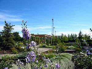
Fort St. John has many fun places for sports and culture. Many of these are in Centennial Park. This park is in the middle of the city.
Centennial Park has the Fort St. John North Peace Museum. You can also find the North Peace Leisure Pool here. The North Peace Arena is home to the Fort St. John Huskies hockey team. There's another arena for kids, an 8-sheet curling rink, an outdoor water park, and a speed skating oval.
Other parks include the Fish Creek Community Forest. About 10 kilometers northwest are Beatton Provincial Park and Charlie Lake Provincial Park.
In the city center is the North Peace Cultural Centre. It has the Fort St. John Public Library. There's also a theatre and the Peace Gallery North art gallery. Visitors also like to see 'Ms. Bubbles,' the world's largest tea-cup pig.
Attractions in Fort St. John
The city's main recreation spot is the Fort St. John Enerplex. It's also called the Pomeroy Sport Centre. It opened in 2010. This big building has two ice rinks for hockey. It also has 12 dressing rooms and meeting rooms.
A cool feature is the indoor speed skating oval, almost Olympic-sized. There's also a 340-meter walking track. The ice surfaces can be removed to create a huge space for events. The Enerplex also has the Energetic Learning Campus. This is a part of the nearby North Peace Secondary School.
Fort St. John has hosted many big events. These include the BC Winter Games in 1984. It also hosted the Northern BC Winter Games several times.
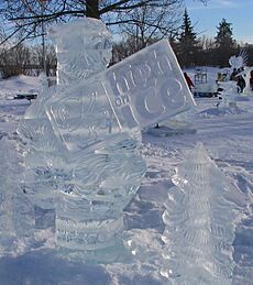
Every August, the Great Canadian Welding Competition happens here. Artists create amazing statues from metal in Centennial Park. In January, the High on Ice Winter Carnival fills the park with ice sculptors. There are also other fun winter activities around town.
How to Get Around (Infrastructure)
Fort St. John is a key place for transportation in the region. Highway 97, also known as the Alaska Highway, runs through the city. It was built in 1942 by the United States Army. This highway goes north to Fort Nelson, the Yukon, and Alaska. It also crosses the Peace River to Dawson Creek. This highway made the city less reliant on the river for travel.
Inside the city, streets are in a grid pattern. The main streets are 100 Street (north-south) and 100 Avenue (east-west). A railway line runs along the eastern and northern edges of the city. The first train arrived in 1958.
The only commercial airport between Dawson Creek and Fort Nelson is the Fort St. John Airport (CYXJ). It's a few miles east of the city. Airlines like Air Canada Jazz and WestJet have regular flights.
The city gets its water from four deep wells near the Peace River. Charlie Lake is a backup source. The water is filtered and treated before it's sent to homes. Sewage is cleaned in two lagoons. The city's fire department has both volunteers and professional firefighters. They protect the city and the nearby rural areas.
Education in Fort St. John
Fort St. John has 9 public schools within the city. One of these is a secondary school. Another 10 schools are just outside the city. All these schools are managed by School District 60 Peace River North. There is also one private Christian school.
Northern Lights College has a campus in Fort St. John. It has a special center for training in oil and gas. This includes a full-sized oil rig for practice! In 2001, about 10% of adults in Fort St. John had a university degree. This was less than the provincial average.
Media in Fort St. John
You can read local news in Fort St. John in the Alaska Highway News and The Northerner newspapers. There's also a free magazine called Northern Groove. It focuses on local music, arts, and live events. The EnergeticCity.ca website is a digital news source for the area.
Radio stations broadcasting from Fort St. John include Move! 98.5 FM, Bounce 101.5 FM, and 92.5 Sunrise FM. There's also a country music station, 100.1 Moose FM.
Freedom of the City
The Freedom of the City is a special honor. It has been given to certain people and military groups in Fort St. John.
Individuals Honored
- Charles “Bud” Hamilton: December 7, 1979.
- William James "Jim" Eglinski: June 24, 2019.
- The Honourable Senator Richard Neufeld: June 24, 2019.
- Jean Leahy: September 9, 2019.
- Sue Popesku: June 11, 2022.
Military Units Honored
- 2276 Royal Canadian Army Cadets: April 10, 2006.
 | Bayard Rustin |
 | Jeannette Carter |
 | Jeremiah A. Brown |


