Dawson Creek facts for kids
Quick facts for kids
Dawson Creek
|
|||
|---|---|---|---|
| The Corporation of the City of Dawson Creek | |||
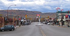
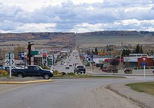
Looking south into downtown Dawson Creek, with the Mile "0" post.
|
|||
|
|||
| Country | Canada | ||
| Province | British Columbia | ||
| Regional district | Peace River | ||
| Incorporated | May 26, 1936 (village) January 6, 1958 (city) |
||
| Government | |||
| • Type | City | ||
| Area | |||
| • City | 24.37 km2 (9.41 sq mi) | ||
| Elevation | 665 m (2,182 ft) | ||
| Population
(2016)
|
|||
| • City | 12,978 | ||
| • Density | 475.4/km2 (1,231/sq mi) | ||
| • Urban | 12,178 | ||
| • Urban density | 475.4/km2 (1,231/sq mi) | ||
| • Metro | 12,178 | ||
| • Metro density | 475.4/km2 (1,231/sq mi) | ||
| Time zone | UTC−07:00 (MST) | ||
| Forward sortation area |
V1G
|
||
| Area code(s) | 250, 778, 236, 672 | ||
| Highways |
|
||
Dawson Creek is a city in northeastern British Columbia, Canada. It covers about 24 square kilometers and had a population of 12,978 people in 2016. The city is named after a creek that flows through it. This creek was named by a survey team in 1879 after George Mercer Dawson, a famous explorer.
Dawson Creek started as a small farming town. It grew into an important regional center in 1932 when a railway line was built there. The city grew even faster in 1942. This was when the US Army used it as a key spot to move supplies for building the Alaska Highway. In the 1950s, new highways and railways connected the city to other parts of British Columbia.
The city is in the Peace River Country, an area with dry, windy prairies. Dawson Creek is known as the "Capital of the Peace" because it's a main service center for the region. It's also called the "Mile 0 City" because it marks the start of the famous Alaska Highway. The city has a special heritage village, an art gallery, and a museum. Every year, it hosts a big fall fair and rodeo.
Contents
History of Dawson Creek
How Dawson Creek Got Its Name
Dawson Creek is named after a creek. In August 1879, a survey team explored the area. A member of the team named the creek after their leader, George Mercer Dawson. Over time, a community grew up near this creek.
Early Settlers and the Railway
Many European-Canadian settlers moved to the Peace River Country to farm. The Canadian government offered land grants starting in 1912, which brought more people. By 1919, Dawson Creek had stores and hotels. It became an important business center.
A major change happened when the Northern Alberta Railways built its western end point near Dawson Creek. The first passenger train arrived on January 15, 1931. The railway brought more settlers and businesses. This growth led Dawson Creek to become a village in May 1936. In 1939, some refugees from Europe settled in the area. By 1941, over 500 people lived in the community.
Building the Alaska Highway
During World War II, the United States decided to build a road to Alaska. In 1942, thousands of US Army workers came to Dawson Creek. The city was the main railway stop for supplies. They built the Alaska Highway in less than a year. Even after the highway was finished, the city kept growing.
In 1943, a large fire and explosion damaged the town center. Five people died and 150 were hurt. Dawson Creek also had a RCAF station during the war, from 1944 to 1946.
Growth and New Connections
By 1951, Dawson Creek had over 3,500 residents. In 1952, the John Hart Highway connected the town to the rest of British Columbia. Another highway, Tupper Highway, linked it to nearby Alberta. This made Dawson Creek a busy crossroads.
In 1958, the village became a city. A new railway line also connected it to Prince George. Between 1951 and 1961, the city's population more than tripled.
Recent Years
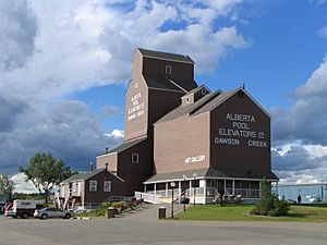
Growth slowed down in the 1960s. In the 1970s, the government moved its offices to the city. Northern Lights College opened a campus in Dawson Creek. Many old wooden grain elevators were replaced with modern ones. Only one historic elevator remains, now an art gallery.
Since the 1970s, other nearby cities like Fort St. John and Grande Prairie have grown a lot. Dawson Creek's population and economy have stayed fairly steady. The city has expanded its borders several times to include new areas for businesses and homes.
Population and People
| Historical population | ||
|---|---|---|
| Year | Pop. | ±% |
| 1941 | 518 | — |
| 1951 | 3,589 | +592.9% |
| 1961 | 10,946 | +205.0% |
| 1981 | 11,373 | +3.9% |
| 1991 | 10,981 | −3.4% |
| 1996 | 11,125 | +1.3% |
| 2001 | 10,754 | −3.3% |
| 2006 | 10,994 | +2.2% |
| 2011 | 11,583 | +5.4% |
| 2016 | 12,178 | +5.1% |
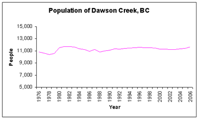
In 2021, Dawson Creek had 12,323 people living there. This was a small increase from 2016. The city's population grew very fast after the Alaska Highway was built in the 1940s. It went from 518 people in 1941 to 3,589 in 1951.
The population reached its highest point in 1966 with 12,392 people. Since then, it has stayed about the same. In 2016, the average household had 2.3 people. About 32% of homes had only one person living there.
Diversity in Dawson Creek
In 2016, about 16% of the city's population were Aboriginal (either Métis or First Nations). Another 10% belonged to a Visible minority group, mainly from the Philippines and South Asia.
Religion in the City
According to the 2021 census, most people in Dawson Creek (about 59%) do not follow a religion. About 36% of residents are Christian. Smaller groups follow Sikhism, Hinduism, Buddhism, Islam, and other religions.
Geography and Climate
Where is Dawson Creek?
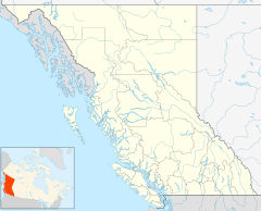
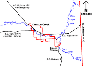
Dawson Creek is located at the base of Bear Mountain. The city grew around the Dawson Creek watercourse, which flows east into the Pouce Coupe River. It's in the southwestern part of the Peace River Country. The land around the city is mostly flat.
Weather in Dawson Creek
Dawson Creek has a subarctic climate. This means it has long, very cold, and dry winters. Summers are generally warm and rainy, but nights can be cool. Temperatures can drop below -30°C for many days in winter. In summer, temperatures rarely reach 30°C. The city often experiences strong winds all year.
Unlike most of British Columbia, Dawson Creek uses Mountain Standard Time all year. This means they don't change their clocks for daylight saving time.
Economy of Dawson Creek
The economy of Dawson Creek relies on four main areas: farming, retail, tourism, and oil and gas.
- Farming: Agriculture has always been very important. The city is a key place for moving farm products. The land around Dawson Creek is good for growing crops like canola, hay, oats, and wheat, and for raising livestock.
- Retail: The city's stores and services serve its residents and people from smaller towns nearby. However, many people travel to Grande Prairie in Alberta to shop. This is because Alberta does not have a provincial sales tax, while British Columbia does.
- Tourism: Dawson Creek is a big tourist spot because it's "Mile 0" of the Alaska Highway. Thousands of people start their journey on this highway here each year. In winter, the city also welcomes workers from the oil and gas industry.
- Oil and Gas: Recent discoveries and higher energy prices have boosted oil and gas activities. This has helped the economy of Dawson Creek, as well as nearby Fort St. John. British Columbia's first wind farm, Bear Mountain Wind Park, was built near the city in 2009.
Getting Around and City Services
Dawson Creek has a road system that was built as the city grew. It has about 88 kilometers of paved roads. The main roads form a grid pattern. Two important roads, 8 Street and Alaska Avenue, meet at a traffic circle. This circle is where the metal statue marking the start of the Alaska Highway is located.
The Alaska Highway (officially British Columbia Highway 97) goes north from Dawson Creek to the Yukon and then to Alaska. Other highways connect Dawson Creek to Chetwynd, Prince George, Grande Prairie, and Peace River.
Dawson Creek also has an airport, the Dawson Creek Airport, which handles commercial flights. Larger airports are in Fort St. John and Grande Prairie. The city used to have passenger train service, but now the railways mainly carry goods like grain, oil, and forestry products.
The city gets its water from the Kiskatinaw River. The water is treated before it reaches homes. Dawson Creek also provides drinking water to nearby Pouce Coupe. The city's wastewater is treated in a special lagoon system before being released into the Pouce Coupe River.
Education in Dawson Creek
Dawson Creek is part of School District 59 Peace River South. The city has four elementary schools: Tremblay, Frank Ross, Crescent Park, and Canalta. It also has one high school, Dawson Creek Secondary School.
There are also private schools in the city. Mountain Christian School teaches students from kindergarten to grade 12. Notre Dame is a Catholic school for grades K-7.
Northern Lights College has a campus in Dawson Creek. It opened in 1975. Students can earn certificates, diplomas, or improve their high school grades here.
Fun and Recreation
Dawson Creek is famous for being "Mile 0" of the Alaska Highway. The Mile "0" post is now in the historic downtown area, near the Northern Alberta Railways (NAR) Park. This park is a popular meeting spot for travelers.
The NAR Park also has the Dawson Creek Art Gallery. It shows art from local artists. The Station Museum, connected to the art gallery, has displays about the railway and the Alaska Highway. Other parks include the Mile Zero Rotary Park and the Walter Wright Pioneer Village.
Popular events in the city include the Dawson Creek Art Gallery auction and the Dawson Creek Spring Rodeo. The biggest event is the Dawson Creek Fall Fair & Exhibition. This five-day event, held since 1953, includes a professional rodeo, a parade, and many exhibitions.
For sports, Dawson Creek has two ice hockey arenas, a curling rink, an indoor swimming pool, and an outdoor ice rink. The South Peace Community Multiplex, built in 2010, has a pool, indoor rodeo grounds, and an ice rink.
Near the city, Bear Mountain offers over 20 kilometers of trails for snowshoeing and cross-country skiing. It also has areas for downhill skiing and hundreds of kilometers of trails for snowmobiles, mountain bikes, and all-terrain vehicles.
Media and News
Dawson Creek has several local newspapers. The Dawson Creek Daily News and Fort St. John's Alaska Highway News are available daily. The Vault Magazine is a free newspaper that comes out every two weeks. The Northeast News is a free weekly paper.
The city has one radio station, 890 CJDC AM, which started in 1947. Other radio stations from Chetwynd and Fort St. John can also be heard in Dawson Creek.
CJDC-TV has been broadcasting from Dawson Creek since 1959. It used to be a CBC Television station but changed to CTV 2 in 2016. A local group also runs a community television station.
Notable People from Dawson Creek
- Dan Brennan, ice hockey player
- Donna Feore, choreographer and musical theatre director
- Roy Forbes, singer-songwriter
- Ben Heppner, opera singer
- Phil Sykes, ice hockey player
- Cayden Lindstrom (born 2006), ice hockey player, picked 4th overall in 2024 NHL draft
- Gary Vandermeulen, international swimmer
See also
 In Spanish: Dawson Creek para niños
 | John T. Biggers |
 | Thomas Blackshear |
 | Mark Bradford |
 | Beverly Buchanan |


