
Pouce Coupe River facts for kids
Quick facts for kids Pouce Coupe River |
|
|---|---|

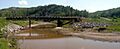
Pouce Coupe River canyon after the confluence with Saskatoon Creek
|
|
| Country | Canada |
| Physical characteristics | |
| Main source | Saddle Hills County, Alberta 860 m (2,820 ft) |
| River mouth | Peace River 380 m (1,250 ft) 56°07′54″N 119°54′40″W / 56.13158°N 119.91116°W |
The Pouce Coupe River is an important river in Alberta and British Columbia, Canada. It is a major branch of the Peace River. Its name is officially spelled Pouce Coupé River, but most people write it without the accent mark.
This river starts in Alberta's Saddle Hills County. It then flows into British Columbia's Peace River Regional District. After that, it goes back into Alberta, into Clear Hills County, where it finally joins the Peace River.
What's in a Name?
The name "Pouce Coupe" comes from a cool story! The area around the river and the village of Pouce Coupe were named after a Beaver Indian Chief called 'Pouscapee'.
The first European settler in this area was Hector Tremblay. He built a small cabin here in 1898. Hector was from France. He translated 'Pouskapee's Prairie' into French words that sounded similar. He chose pouce coupé, which means "cut thumb" or "cut-off thumb". That's how the river and the area got their unique name!
The River's Journey
The Pouce Coupe River begins in a small lake in northern Alberta. It starts high up, at about 860 meters (2,820 feet) above sea level. This area is known as the Pouce Coupe Prairie. It is located west of towns like Spirit River and Woking.
From its start, the river flows west. It picks up water from a stream called Boone Creek. Then, it reaches the border between British Columbia and Alberta.
The river then turns northwest towards the village of Pouce Coupe. You can find the Pouce Coupe Regional Park along the river's banks. This park is east of the village and Highway 2. Here, another stream, Bissette Creek, joins the river.
The Pouce Coupe River continues its journey. It receives water from Dawson Creek, east of the city of Dawson Creek. After that, it turns northeast and enters Alberta again. This happens north of Highway 49.
In this part, the river flows through a deep canyon. This canyon can be as deep as 220 meters (720 feet)! You can find amazing Ammonite fossils in the rock layers of this canyon. Some of these fossils are even displayed at the Dawson Creek Northern Alberta Railways Park museum. The river keeps flowing north until it empties into the Peace River. This meeting point is south of Highway 64, at an elevation of about 380 meters (1,250 feet).
River Connections
The Pouce Coupe River has many smaller streams and creeks that flow into it along its path. These are called tributaries. It also flows under several bridges as it winds through the landscape.
Images for kids
-
Landry road bridge over the Pouce Coupe River
