Charlie Lake (British Columbia) facts for kids
Quick facts for kids Charlie Lake |
|
|---|---|

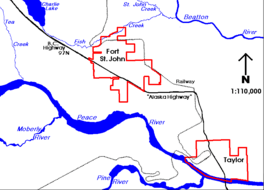
Charlie Lake situated north-west of Fort St. John
|
|
| Coordinates | 56°19′29″N 120°58′31″W / 56.32484°N 120.97536°W |
| Primary inflows | Stoddart Creek |
| Primary outflows | Stoddart Creek |
| Basin countries | Canada |
| Max. length | 13 kilometers (8.1 mi) |
| Max. width | 3 km (1.9 mi) |
| Surface elevation | 700 m (2,300 ft) |
| Settlements | Charlie Lake |
Charlie Lake is a beautiful lake in north-eastern British Columbia, Canada. It is located about 8 km (5.0 mi) west of the city of Fort St. John. The famous Alaska Highway runs right by it. This lake is very important because it provides clean drinking water for the people living in Fort St. John.
Scientists have also named a special rock layer after the lake. This layer is called the Charlie Lake Formation. It is part of a much larger area of rocks in western Canada.
Where is Charlie Lake?
Charlie Lake sits high up, at an elevation of 700 m (2,300 ft). This means it is about 700 meters above sea level. The lake is actually part of a creek called Stoddart Creek.
Stoddart Creek flows into the lake and then out of it. This creek is a smaller stream that eventually joins the Beatton River. The Beatton River then flows into the mighty Peace River. So, Charlie Lake is connected to a big network of rivers!
Parks and the Community
There are two fun parks right on the shores of Charlie Lake. On the west side, you'll find Charlie Lake Provincial Park. On the east side, there's Beatton Provincial Park. Both parks offer great chances to enjoy nature.
The small community of Charlie Lake is located at the very southern end of the lake. It's a quiet place where people can live close to this important body of water.
 | Charles R. Drew |
 | Benjamin Banneker |
 | Jane C. Wright |
 | Roger Arliner Young |


