
Fort Nelson River facts for kids
Quick facts for kids Fort Nelson River |
|
|---|---|
| Country | Canada |
| Province | British Columbia |
| Physical characteristics | |
| Main source | Forks of Sikanni Chief River and Fontas River 58°17′08″N 121°45′13″W / 58.28543°N 121.75355°W 360 m (1,180 ft) |
| River mouth | Liard River 59°32′47″N 123°59′40″W / 59.54639°N 123.99432°W 260 m (850 ft) |
| Length | 517 km (321 mi) |
| Basin features | |
| Basin size | 55,900 km2 (21,600 sq mi) |
The Fort Nelson River is a major river in north-eastern British Columbia, Canada. It is sometimes called the Nelson River for short. This river flows about 517 kilometres (321 mi) (321 miles) towards the north-west. It eventually joins the Liard River, which then flows into the Mackenzie River. The Mackenzie River is one of the longest rivers in North America and empties into the Arctic Ocean.
The Fort Nelson River collects water from a huge area of land, covering about 55,900 square kilometres (21,600 sq mi) (21,583 square miles). It starts where two other rivers, the Fontas River and the Sikanni Chief River, meet. Other important rivers that flow into the Fort Nelson River include the Sahtaneh River and the Muskwa River. The Sikanni Chief River begins in the Rocky Mountains, making it the ultimate source of the Fort Nelson River.
The land around the river is mostly flat. It has many boreal forests, which are like northern evergreen forests, and muskeg areas, which are wet, spongy lands. This region is full of different kinds of wildlife. Important jobs here include forestry (cutting down trees) and mining, especially for oil and gas.
Contents
History of the Fort Nelson River
The Fort Nelson River has a long and interesting history. Long ago, the Dene and Sekani First Nations (Indigenous peoples of Canada) used the river. They traveled on it to find food and to trade goods with other groups.
The river gets its name from the town of Fort Nelson. This town was started in 1805 by a company called the North West Company. They built a fur trading post near where the Fort Nelson River meets the Muskwa River. People would trade animal furs there.
Over time, the original trading post and village at Nelson Forks were left behind. The town of Fort Nelson moved about eight kilometers (five miles) southwest, further up the Muskwa River. This happened in the 1940s when the Alaska Highway was built. The highway made it easier to travel, so people didn't rely on the rivers as much. Today, there are no communities directly along the Fort Nelson River.
Where the Fort Nelson River Flows
The Fort Nelson River officially begins where the Sikanni Chief River and Fontas River join together. This meeting point is about 360 metres (1,180 ft) (1,181 feet) above sea level. From there, the river flows mostly north-west and then north.
North of a place called Fontas, the river's path runs alongside the BC Rail train tracks. As it continues, smaller streams like Elleh Creek and Klua Creek add their water to the river. It then flows north-west, close to Andy Bailey Provincial Park. Near the town of Fort Nelson, the Muskwa River flows into it, adding more water.
Further north, the Fort Nelson River receives water from McConachie Creek, Cridland Creek, and the Sahtaneh River. The Sahtaneh River also brings water from the Snake River. The Fort Nelson River then turns north-west and west. Here, many more streams join it, including Shush Creek, Onion Creek, Tsimeh Creek, Stanolind Creek, and the Kiwigana River.
The Liard Highway crosses the river as it continues west. Finally, after receiving water from Tsoo Creek, Etane Creek, Obole Creek, and Capot-Blanc Creek, the Fort Nelson River flows into the Liard River at Nelson Forks. This is at an elevation of about 260 metres (850 ft) (853 feet) above sea level.
All of the Fort Nelson River's water travels down the Liard River, then into the mighty Mackenzie River, and eventually reaches the cold Arctic Ocean.
Local Views on the River's Start
There is a difference in how people locally understand where the Fort Nelson River begins. Especially among the Dene and Cree people of the Fort Nelson First Nation, it is often taught that the Fort Nelson River doesn't start where the Fontas and Sikanni Chief Rivers meet.
Instead, they believe the Fort Nelson River truly begins further downstream. They say it starts where the Sikanni Chief River meets the larger Muskwa River. This spot is important because it was the original location of Fort Nelson, the community that gave the river its name.
The original Fort Nelson site was mostly abandoned after World War II. This was because the Alaska Highway became the main way to travel, replacing the river systems. The difference in beliefs about the river's start likely comes from the different explorers and surveyors who mapped the land in the 1800s and early 1900s. Their work led to the official maps we see today, but local traditions often follow a different understanding.
Tributaries of the Fort Nelson River
Here are the rivers and creeks that flow into the Fort Nelson River, listed from its beginning to its end:
- Sikanni Chief River
- Fontas River
- Elleh Creek
- Klua Creek
- Muskwa River
- McConachie Creek
- Cridland Creek
- Snake River
- Hoffard Creek
- Chuatse Creek
- Utahn Creek
- Sahtaneh River
- Lichen Creek
- Gunnell Creek
- Courvoisier Creek
- Komie Creek
- Shush Creek
- Onion Creek
- Tsimeh Creek
- Stanolind Creek
- Kiwigana River
- Tsoo Creek
- Etane Creek
- Obole Creek
- Capot-Blanc Creek
Images for kids
-
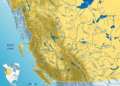
Western Canada rivers with the Fort Nelson River marked.

