
British Columbia Highway 20 facts for kids
Quick facts for kids
|
||||
|---|---|---|---|---|
| Chilcotin-Bella Coola Highway | ||||
| Lua error in Module:Infobox_road/map at line 15: attempt to index field 'wikibase' (a nil value). | ||||
 |
||||
| Route information | ||||
| Length | 457 km (284 mi) | |||
| Existed | 1953–present | |||
| Major junctions | ||||
| West end | Government Wharf in Bella Coola | |||
| East end | ||||
| Highway system | ||||
British Columbia provincial highways
|
||||

Highway 20, also known as the Chilcotin Highway, is a major road in British Columbia, Canada. It's officially called the Alexander MacKenzie Highway. This highway is one of two main routes that go from east to west in the middle part of British Columbia.
Highway 20 stretches for 457 kilometers (284 miles). It starts in Williams Lake and goes west through the Chilcotin region. It ends at North Bentinck Arm, an inlet from the Pacific Ocean, where the town of Bella Coola is located. Most of the highway is paved, which helps with moving timber from the area. You can expect to see trucks carrying logs and other vehicles related to ranching on this road.
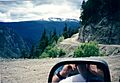
A very famous part of Highway 20 is near the western end, between Anahim Lake and Bella Coola. People call this section the Hill or The Precipice. It's known for being very steep and challenging to drive.
Contents
Driving The Hill
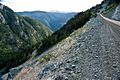
This part of Highway 20 crosses the Coast Mountains through Heckman Pass. This pass is inside Tweedsmuir South Provincial Park and is very high, at 1,487 meters (4,879 feet) above sea level.
From Heckman Pass, the road goes down for 43 kilometers (27 miles). It's a steep and narrow road with many sharp turns, called hairpin turns. There are also two big switchbacks, which are zig-zag turns that help cars go up or down steep hills.
A 9-kilometer (5.6-mile) section of the road is especially steep. It has grades of up to 18%, which means it drops about 1 foot for every 6 feet you travel forward. The road is winding, and in some places, it's only wide enough for one vehicle.
On one side, there are cliffs, and on the other, there's a drop of hundreds of meters. There are often no guardrails to protect cars from falling. Some tourists who have driven to Bella Coola from Williams Lake have found the drive so scary that they refused to drive back. They had to leave by boat or a special float plane instead!
Building the "Freedom Road"
Before 1953, Highway 20 ended at Anahim Lake. This was 137 kilometers (85 miles) away from Bella Coola. The government thought the mountains were too difficult to build a road through. This meant Bella Coola could not be reached by car.
But the people living there really wanted a road. So, local volunteers decided to build it themselves! They worked from both ends of the road, using two bulldozers. They bought supplies using credit, and slowly, they connected the two towns. This road became known as the "Freedom Road" because it gave the people of Bella Coola freedom to travel by car.
Exploring the Route
Highway 20 is a very scenic road, but it doesn't have many towns or people living along it. It starts in Williams Lake where it meets Highway 97.
Journey to the Plateau
The highway slowly goes up for 23 kilometers (14 miles) until it crosses the Fraser River. It crosses the river on the Sheep Creek Bridge. After the bridge, the road climbs steeply with many switchbacks. This takes you up to the Chilcotin Plateau. A long time ago, before the Sheep Creek Bridge was built, cars crossed the Fraser River on an old suspension bridge.
Towns and Landmarks
At 36 kilometers (22 miles) along the highway, you would have passed the Williams Lake LORAN-C Tower. This tall tower was part of a system that helped ships navigate. It was taken down in 2011.
As you continue, you'll pass through small communities:
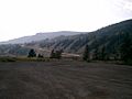
- At 52 kilometers (32 miles), you reach Riske Creek, which has about 165 people.
- At 94 kilometers (58 miles), you'll find Hanceville, a tiny village with about 68 people.
- Around 104 kilometers (64 miles), the highway goes past Anahim Reserve, a Chilcotin community.
- At 114 kilometers (71 miles), you arrive in Alexis Creek, which has about 317 people.
From Alexis Creek, it's a longer drive of 122 kilometers (76 miles) to the next town, Tatla Lake. About 147 people live there.
Towards the Coast
Another 54 kilometers (34 miles) west of Tatla Lake is Nimpo Lake. This lake is a base for float planes, which are planes that can land on water. Just west of Nimpo Lake, the highway crosses the Dean River.
Then you reach Anahim Lake, which has about 163 people, and a nearby Indian reserve. This is at 310 kilometers (193 miles) from the start of the highway.
About 35 kilometers (22 miles) west of Anahim Lake, Highway 20 enters Tweedsmuir South Provincial Park. A little further, at 6.2 kilometers (3.9 miles), it crosses into the Central Coast Regional District at Heckman Pass.
After another 20 kilometers (12 miles), the highway meets the Atnarko River. It follows this river west for 18 kilometers (11 miles). The Atnarko River then joins the Talchako River to form the Bella Coola River. Highway 20 then follows the Bella Coola River for 10 kilometers (6 miles) until it crosses Burnt Bridge Creek. At this point, the highway leaves the park.
The highway continues to follow the Bella Coola River for another 27 kilometers (17 miles) to Hagensborg. From there, it's another 20 kilometers (12 miles) to the center of Bella Coola, which has about 2,500 people. The highway ends 4.8 kilometers (3.0 miles) further at the BC Ferry terminal, where you can take a ferry to other places.
Images for kids
-
Descending Bella Coola Hill
-
Sheep Creek Bridge across the Chilcotin River
-
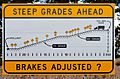
Warning sign on pullout at the top of The Hill
-
The LORAN-C Station near Riske Creek
-
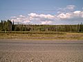
Near Riske Creek
-
Looking East between Kleena Kleene and Nimpo Lake
-
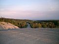
View from the top of the Hill


