Metro Vancouver watersheds facts for kids
The Metro Vancouver watersheds are super important areas that provide clean drinking water to about 2.4 million people in the Lower Mainland of British Columbia. This includes big cities like Vancouver, Langley, and Richmond. Metro Vancouver, the group in charge, helps 21 cities and towns, plus a First Nation community.
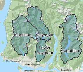
There are three main watersheds, from west to east: the Capilano (which is 19,545 hectares), the Seymour (12,375 hectares), and the Coquitlam (20,461 hectares). They are located in the North Shore Mountains and Coquitlam Mountain. Each watershed has a special lake called a reservoir to store water. These reservoirs get their water from lots of rain (about 3.5 meters) and snow (about 4.5 meters) every year.
Over the years, there have been some interesting stories and debates about these watersheds. People have talked about logging (cutting down trees), building highways, and protecting salmon.
Contents
How Our Water System Began
Early Days and Water Needs
The city of Vancouver started growing very quickly in the late 1880s. People needed a good, steady supply of water. So, in April 1886, two companies were created: the Vancouver Water Works Company and the Coquitlam Water Works Company. Their job was to find and provide clean water for everyone.
Capilano and Seymour Water Sources
In 1887, the Capilano River was chosen as the main water source for Vancouver. Workers built a pipe 11 kilometers upstream from where the river meets the ocean. This pipe carried water across the First Narrows of Burrard Inlet and into the city.
As more people moved to the Vancouver area, even more water was needed. In 1905, Vancouver's Mayor, Frederick Buscombe, saw that the Seymour River could also be a great water source. To protect this water, the B.C. government decided to set aside the Capilano and Seymour areas as special reserves for water supply. This happened in 1905 for Capilano and 1906 for Seymour. These agreements were for 999 years!
However, some land was already owned by private companies, and some mining and timber claims were still allowed. In 1908, the first water intake was built in the Seymour River. It was a wooden pipe, 11 kilometers from the river's mouth. A second intake was added in 1913. This system provided water to North Vancouver and later to Vancouver, Burnaby, and Richmond. In 1927, the wooden pipe was replaced with a stronger steel one.
In 1928, a small dam was built on the Seymour River, creating a 180-acre reservoir. This dam and reservoir were made much bigger in 1961, becoming the size they are today.
Coquitlam's Water Supply
From 1892, Coquitlam Lake provided drinking water for the city of New Westminster. In 1902, the Vancouver Power Company (VPC) took over this job. The water intake was first at the lower end of Coquitlam Lake. A new intake was put in place in 1905. In 1909, the government gave the VPC rights to use the water from the Coquitlam reservoir and most of the water flowing into it.
History of Logging in Watersheds
Early Tree Cutting: 1918–1931
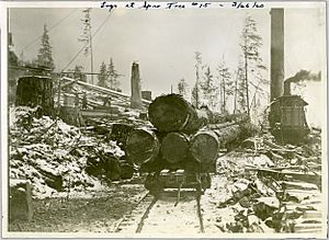
Between 1918 and 1931, a company called Capilano Timber Company cut down about 3,200 hectares of old-growth forest in the Capilano watershed. They had permission to do this from before the watershed was protected in 1905. People in Vancouver became very worried that this logging would harm the quality of their drinking water. There were also many fires caused by logging, with one burning over 3,200 acres.
In 1922, an expert named Ernest Cleveland said that the watersheds should be fully controlled by the people in charge of the water supply. He believed no more land should be used for cutting timber. There was a big debate about this.
On February 3, 1926, the Greater Vancouver Water District (GVWD) was officially formed, with Ernest Cleveland as its leader. In 1927, the GVWD got a 999-year lease from the government for all the land and timber in the Capilano and Seymour watersheds. This meant they could protect the water. The Capilano Timber Company stopped logging in 1931. The GVWD slowly bought out all logging companies, and the Capilano and Seymour watersheds became completely closed to logging. The Coquitlam watershed was also protected in 1942.
Logging for Protection and Growth
For many years, the GVWD worked hard to keep logging out of the watersheds. But after Ernest Cleveland passed away in 1952, some forestry companies wanted to start logging again to make money. They argued that cutting down older trees would protect the forests from fires and bugs.
In 1958, logging began in the Seymour watershed to clear land for a new dam reservoir. About 487 acres were cleared, and the wood was sold for a lot of money. In 1967, the rules changed. The GVWD was now allowed to build roads and cut down old-growth forests in all three watersheds. The idea was that managing the timber would help protect and improve the water supply.
From 1961 to 1992, over 300 kilometers of logging roads were built through old forests, steep mountains, and near creeks. About 5,000 hectares of forest were logged because of road building and tree cutting. Even though studies showed that logging could harm water quality, the GVWD kept saying it was helping.
The End of Logging
In 1988, a group called the Western Canada Wilderness Committee started a public campaign to stop logging. Other groups also spoke out strongly. Finally, in 1999, the GVWD decided to end all logging in the Greater Vancouver watersheds. The special agreement that allowed logging was canceled on February 8, 2002. They also promised to close down the logging roads.
Quick Look at Watershed Logging
| Capilano watershed | Seymour Watershed | Coquitlam Watershed | |
|---|---|---|---|
| Early Logging (above water supply intake) | 1918–1931: 3200 hectares | No logging before 1962 | No logging before 1972 |
| Recent Logging | 1964–1994: 1250 hectares | 1962–1992: 1300 hectares | 1972–1993: 1400 hectares |
| Roads Built (approximate) | 1964–1992: 100 kilometers | 1961–1992: 100 kilometers | 1972–1992: 100 kilometers |
The Capilano Highway Debate
In 1929, someone suggested building a public highway through the Capilano watershed. This road would connect North Vancouver to Squamish and Garibaldi Park. From 1950 to 1954, a group called the Howe Sound Highway Committee pushed for this road. At that time, the only way to get from Vancouver to Squamish was by ferry.
The proposed highway would follow existing power line roads and logging roads. However, the GVWD strongly believed that the watersheds needed to be kept isolated to protect the water. In 1954, the highway committee gave up. The idea came up again in 1990 when a rock slide blocked the Sea to Sky highway.
Important Dates for Watershed Protection
| Date | Event |
|---|---|
| 1905 | BC Government sets aside Capilano Crown lands for water supply only. |
| 1906 | BC Government sets aside Seymour Crown lands for water supply only. |
| 1910 | Coquitlam watershed is protected from all logging. |
| 1926 | Greater Vancouver Water District (GVRD) is formed. |
| 1927 | A 999-year agreement (the Indenture) protects Crown land in Seymour and Capilano watersheds from logging. |
| 1942 | Coquitlam watershed is included in the Indenture agreement. |
| 1967 | The Indenture is changed to allow the GVWD to log in the watersheds for water quality protection. |
| 2002 | The GVRD Board decides to cancel the logging agreement. |
Reservoirs and Water Collection Areas
Capilano Watershed
The Capilano watershed covers 19,545 hectares. It's located west of Grouse Mountain and north of the famous Capilano Suspension Bridge. Streams and creeks in this mountain area flow into the Capilano River. This water then goes into Capilano Lake, which is a reservoir built in 1954 to store water.
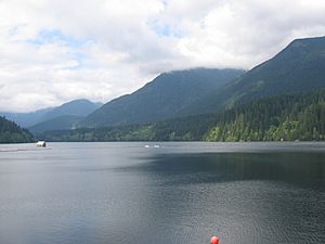
There are 11 main smaller streams that join the Capilano River as it flows from Capilano Mountain to the reservoir. Some of these are Andrews Creek, Daniels Creek, and Dean Creek. Capilano reservoir is 5.8 kilometers long, 800 meters wide, and 75 meters deep. It can hold a huge 57.9 billion liters of water! The Cleveland Dam holds the water back at the south end. The Capilano River continues south of the dam and flows into the Burrard Inlet.
Seymour Watershed
The Seymour watershed is a long, narrow valley about 12,375 hectares in size. It's east of Cathedral Mountain and northwest of the Fannin Range mountains and Mount Seymour Provincial Park. It stretches up to 20 kilometers north to south.
The reservoir here is Seymour Lake. It can hold 32 billion liters of water and is usually full in the fall, winter, and spring. Most of its water comes from the Seymour River. Seymour Lake started as a small reservoir when the Seymour Falls Dam was built in 1928. When the dam was made bigger in 1960, Seymour Reservoir grew a lot. It is now 6.5 kilometers long. There are also two high-mountain reservoirs, Loch Lomond and Burwell Lake, that can provide extra water during dry times.
Coquitlam Watershed
The Coquitlam watershed is the biggest of the three, covering 20,461 hectares. It's north of the city of Coquitlam, east of Indian Arm, and west of Coquitlam Mountain. Coquitlam Lake, a natural lake, is the reservoir for this watershed. Water flows into it from the Coquitlam River, which starts at Disappointment Lake further north. Many creeks and streams from the surrounding mountains also drain into the Coquitlam River and Coquitlam Lake. The lake was dammed in 1905 by the BC Electric Railway Company. The Coquitlam River flows south of the dam, through the city, and eventually joins the Fraser River.
Human Impacts and Environmental Concerns
Salmon in Coquitlam Lake
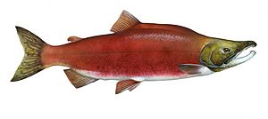
The original name for Coquitlam, Kwikwetlem, means "red fish up the river." This is because many sockeye salmon used to lay their eggs around Coquitlam Lake. When the Coquitlam Dam was built, it caused problems for the four types of salmon that spawned in the Coquitlam River: sockeye, coho, chum, and steelhead.
Thousands of spawning salmon used to swim through Coquitlam Lake. The dam, built for water supply and power, stopped salmon from reaching their spawning grounds in the upper part of the Coquitlam River. Some areas where salmon laid eggs were destroyed when the dam raised the lake's water level. By 1913, sockeye salmon disappeared from the area. Over the last 100 years, the other salmon types also struggled, but they managed to survive and even improve later on. The dam wasn't the only problem; too much fishing and poor habitat quality also hurt salmon numbers.
In the past, some people even wanted to get rid of the salmon because they worried the fish would make Coquitlam Lake's water supply dirty. The City of New Westminster hired First Nations people to remove dead salmon from the water intake screens.
Since the early 1990s, the government has focused on protecting salmon spawning areas. The Department of Fisheries and Oceans has worked for years to help the Coquitlam salmon run. Sockeye salmon have even returned to the Coquitlam River after 100 years! They are now watched carefully to help their numbers grow and to make sure a special fish ladder in the dam works well.
Many people, volunteer groups, and cities have also tried to save the salmon. Over the past 20 years, many plans and projects have been put in place to understand and increase salmon populations in the Coquitlam Watershed. A 2011 plan aimed to improve habitats for all salmon species, including sockeye, coho, steelhead, pink, cutthroat, and chinook.
Erosion and Landslides
Metro Vancouver gets a lot of rain. This heavy rain can cause erosion and landslides along the stream banks in the watersheds. This not only makes Vancouver's drinking water cloudy, but it also harms salmon habitats, land ecosystems, and human-made buildings and roads.
Climate Change Effects
In the summer of 2015, Metro Vancouver had a very dry summer. The three reservoirs had very low water levels because there wasn't enough precipitation (rain or snow). In May, June, July, and August, Vancouver received very little rain. When the reservoir levels dropped too low in July, strict water restrictions were put in place. People were not allowed to water their lawns, wash cars outside, or refill pools.
Public Access to Watersheds
All Metro Vancouver watersheds are closed to the public. This is to help keep the water supply clean and safe from human disturbances, like pollution and erosion.
However, you can join a registered watershed tour to visit these areas. In the summer, guided bus tours are offered in the Capilano, Seymour, and Coquitlam watersheds. In the winter, you can take snowshoe tours on Mount Seymour.
 | Leon Lynch |
 | Milton P. Webster |
 | Ferdinand Smith |


