Coquitlam Mountain facts for kids
Quick facts for kids Coquitlam Mountain |
|
|---|---|

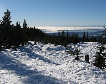
View from Burke Mountain on the southern ridge of Coquitlam Mountain.
|
|
| Highest point | |
| Elevation | 1,583 m (5,194 ft) |
| Prominence | 698 m (2,290 ft) |
| Geography | |
| Location | Coquitlam, British Columbia |
| Parent range | Pacific Ranges |
| Topo map | NTS 92G/07 |
Coquitlam Mountain is a tall mountain found in British Columbia, Canada. It is located in the northeast part of the city of Coquitlam. This mountain stands about 1,583 meters (5,194 feet) high. It is found near Coquitlam Lake and Minnekhada Regional Park.
The mountain is part of the Pacific Ranges. It sits completely inside the Coquitlam watershed. This means that people are not allowed to visit the mountain. Mount Burke is a nearby mountain that forms Coquitlam Mountain's southern side.
Exploring Coquitlam Mountain
The first time anyone officially climbed Coquitlam Mountain was in 1918. Two explorers, P. James and D. Munday, made this first recorded trip. The mountain got its name, Coquitlam Mountain, on May 3, 1951. It was named after the nearby Coquitlam River.
Weather at the Peak
The top of Coquitlam Mountain has a subarctic climate. This means it experiences very cold winters and cool summers. It gets a lot of snow and rain throughout the year.
 | Delilah Pierce |
 | Gordon Parks |
 | Augusta Savage |
 | Charles Ethan Porter |

